
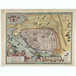
Chinae, olim Sinarum regionis. . .
The first printed map of China. It is signed by Ludovico Georgio, whose real name was Luis Jorge de Barbuda. He was a Portuguese Jesuit cartographer and besides that a sp...
Place & Date: Antwerp, 1598
Chinae, olim Sinarum regionis. . .
The first printed map of China. It is signed by Ludovico Georgio, whose real name was Luis Jorge de Barbuda. He was a Portuguese Jesuit cartographer and besides that a sp...
Place & Date: Antwerp, 1598
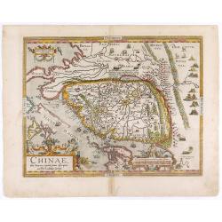
Chinae, olim Sinarum regionis. . .
The first printed map of China. It is signed by Ludovico Georgio, whose real name was Luis Jorge de Barbuda. He was a Portuguese Jesuit cartographer and besides that a sp...
- $6000 / ≈ €5130
Place & Date: Antwerp, 1608
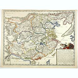
La Chine Royaume. . .
An important and attractive French map of the whole of China, the northern tip of the Philippines, with a strangely curved Korea and an under-sized Taiwan here called &qu...
- $2600 / ≈ €2223
Place & Date: Paris, 1656
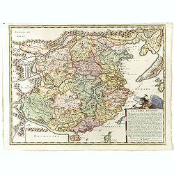
La Chine Royaume. . .
An important and attractive French map of the whole of China, northern tip of the Philippines, with a strangely curved Korea and an under-sized Taiwan here called "Y...
Place & Date: Paris, 1656
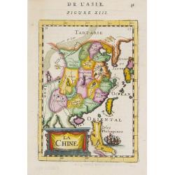
La Chine.
A charming small map of China, Taiwan, Philippines, Korea and Kyushu (Japan). By Allain Manneson Mallet (1630-1706), a well traveled military engineer and geographer who ...
- $300 / ≈ €256
Place & Date: Paris, 1720

Hedendaegsche Historie of tegenwoordige staet van alle volkeren 1 deel. (Volume 1 - China, Japan, Phillippines, Moluccas)
This provides an interesting illustrated description of China, Japan, the Phillippines, Moluccas. Including a map of China, Korea, and Japan, with the Sea between Korea a...
Place & Date: Amsterdam, 1734

A chart of the China Sea inscribed to Monsr. D'APRES de MANNEVILLETTE .. To A.Dalrymple.
This most important milestone chart is based upon the surveys made from navigational surveys by Alexander Dalrymple (1737-1808]. He was the first hydrographer of the Brit...
Place & Date: Paris, ca 1775
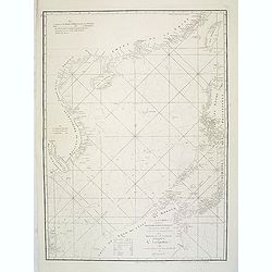
A chart of the China Sea inscribed to Monsr. D'APRES de MANNEVILLETTE .. To A.Dalrymple.
Most important milestone sea chart is based upon the surveys made from navigational surveys by Alexander Dalrymple (1737-1808]. He was the first Hydrographer of the Briti...
Place & Date: Paris, ca. 1775
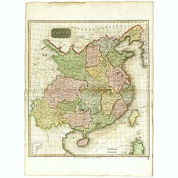
China.
Highly detailed map of China including Formosa (Taiwan), Hainan, and part of Luzon in the Philippines. The map show the Tract of the Hindoostan and Lion with the British ...
Place & Date: Edinburgh, 1815

China Southeast Coast.
A very large US Army and Naval map of the south east coast of China, published during the second world war. Map extent is from Kweichow Province in the west, to Kwangsi P...
- $1250 / ≈ €1069
Place & Date: [New York], 1944