Browse Listings in America > South America

Nieuwe gemeten kaart van de colonie de Berbice : met der zelver plantagien en de namen der bezitters in het ligt gebragt door Reiner & Iosua Ottens kaartverkopers te Amsterdam 1740.
Rare separately published map of the colony of Berbice in present-day Guyana showing the Berbice River Valley and the plantations along the river. North on map of the col...
Place & Date: Amsterdam, 1740
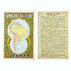
America del Sur Filatelica.
Unique manuscript map of South America. Award-winning manuscript card, prepared by Antonio Raggio for the 11th Congreso de la Union Postal Universal (World Postal Congres...
Place & Date: Buenos Aires, 1939
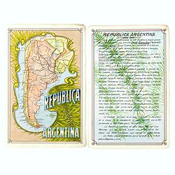
Republica Argentina.
Unique manuscript map of Argentina. Award-winning manuscript card, prepared by Antonio Raggio for the 11th Congreso de la Union Postal Universal (World Postal Congress) E...
Place & Date: Buenos Aires, 1939
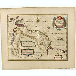
Guiana sive Amazonum Regio.
Copper engraving, hand colored in outline when published. A highly decorative map showing Guiana extending westwards to Trinidad and Margarita Island, dominated by a huge...
Place & Date: Amsterdam, 1645
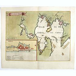
Sinus Omnium Sanctoru. Bahia de Todos os Sanctos.
RARE. First Atlas Major issue: originally issued by Blaeu in Casper van Baarle's 'Rerum per Octennium in Brasilia' (1647) dedicated to the former Governor of the Dutch co...
Place & Date: Amsterdam, 1664
Paraguayo prov. de Rio de La Plata cum regionibus..
A beautiful map of Paraguay, and parts of Peru, Chile, Argentina, Brazil and Bolivia. Much of the area was still "Terra Incognita" so there are few towns and ci...
- $500 / ≈ €468
Place & Date: Amsterdam, 1644
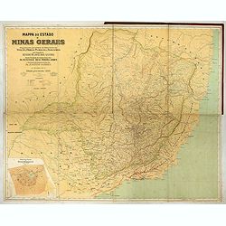
Mappa do estado de Minas Geraes.
Monumental map of the Minas Geraes State, the Brazilian Eldorado, with an inset plan of Belo Horizonte. Scale of 1 : 100 000. Lith. Hartmann-Reichenbach, 1910. Organized ...
- $1000 / ≈ €936
Place & Date: Rio de Janeiro, 1910 -1911
Carte de la Guyane Françoise et l'Isle de Cayenne..
A well engraved and highly detailed chart of French Guiana and the island of Cayenne. Made in 1763 by Jacques Bellin (1703-72), a prolific cartographer assigned the Minis...
- $500 / ≈ €468
Place & Date: Paris, 1763
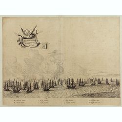
Quartum Praelium Coniovian inter et Fluvium Rio Grande XVII Ian
Decorative engraving of the fourth sea battle with the Portuguese fleet offshore at the Rio Grande, in1640. Engraved by J. van Brosterhuyzen after a design by Frans J. Po...
- $500 / ≈ €468
Place & Date: Joannes Blaeu, Amsterdam 1647
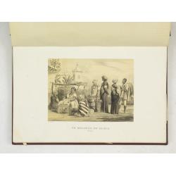
(Album Pallière. Escenas Americanas. Reduccion de Cuadros, aquarelles y bosquejos.)
51 (of 52 )beautifully lithographed plates on tinted ground, lithographed by J. Pelvilain after designs by Juan Léon Palliere. One plate missing : santiagueña tejiendo ...
- $10000 / ≈ €9357
Place & Date: Buenos Aires, en venta en la casa de los S.res Fusoni H.nos, ca. 1850
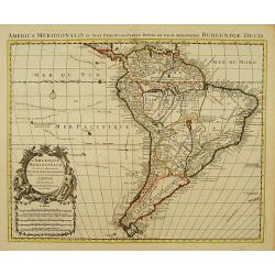
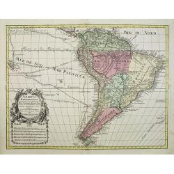
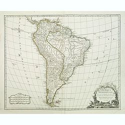
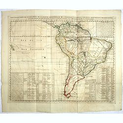
L'Amerique Meridionale Dressée sur les Observations..
Detailed map of South America prepared by De L'Isle, with fine title cartouche.The map is from a Dutch edition of De L'Isle's work entitled, Atlas Nouveau, Contenant Tout...
- $500 / ≈ €468
Place & Date: Amsterdam c. 1745
Amérique Méridionale . . .
Detailed map of South America, prepared by A. H. Basset, rue Saint-Jacques, no. 64, Paris and published in Atlas classique et Universel de Géographie . . . .The engraver...
- $100 / ≈ €94
Place & Date: Paris, A.H. Basset, 1828
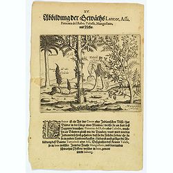
Plants Lantor, Assa, Pimenta, Mangostan and Pepper.
Lantor is a kind of coconut palm (or Indian nut) with fronds as long as a human body. These fronds are used as paper. Pimenta del Rabo (or cubebe) grows grape-like on tre...
- $80 / ≈ €75
Place & Date: Frankfurt, 1598
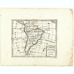
L'America meridionale divisa nei suoi principali stati.
Rare map of south America, from "Atlante Novissimo ad uso Dei Giovani Studiosi Contenuto In Carte XXVII.", published by Giovanni Zempel in Rome, ca. 1780.The ma...
- $100 / ≈ €94
Place & Date: Rome, 1780
![Mapa geral do Brasil / organizado pelos J. Carneiro da Silva e Pedro Voss. [Together with] Micro geografia do Brasil. [Together with] Pequeno Mapa do Brasil.](/uploads/cache/45466-250x250.jpg)
Mapa geral do Brasil / organizado pelos J. Carneiro da Silva e Pedro Voss. [Together with] Micro geografia do Brasil. [Together with] Pequeno Mapa do Brasil.
Large folding national map published by "Comp. Melhoramentos de São Paulo Industrias de Papel". Nova edicao revista 1946. Figurs all states. "Futuro Distr...
- $300 / ≈ €281
Place & Date: São Paulo, 1946
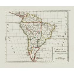
Amérique Méridionale.
Nice small map of South America. Dated 1748. From Atlas Portatif Universel, by Robert de Vaugondy.Page 105 outside border top right. Mary Sponberg Pedley does not mention...
- $75 / ≈ €70
Place & Date: Paris, later than 1748
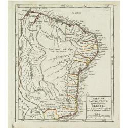
Terre de Sainte Croix, nommée à présent Bresil.
Detailed small map showing most part of the Brazilian seacoasts, from the mouth of the Amazon River as far as the island of Sao Sebastiao.From Atlas Portatif Universel, b...
- $75 / ≈ €70
Place & Date: Paris, later than 1749
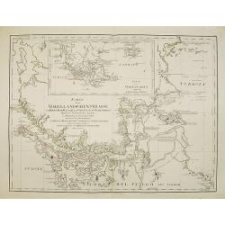
Karte der Magellanischen-Strasse. . .
Very detailed map of Strait of Magellan, with in top inset map of Southern tip of South America with the Falklands. Prepared by Don Juan de La Cruz of Spain.Engraved by J...
- $600 / ≈ €561
Place & Date: Vienna, 1789
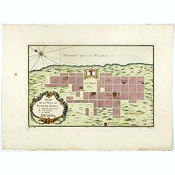
Plan de la ville de Buenos-Ayres.
Early plan of Buenos-Ayres city. Across the top is an extensive list of 22 important sites and locations keyed to the plan with tiny letters and numbers.Jacques Nicolaas ...
- $300 / ≈ €281
Place & Date: Paris, 1750
America Meridionalis.
This is the more scarce edition with the title cartouche lower left surrounded by Neptune and a native Indian.A rather accurate depiction and descriptions of South Americ...
- $550 / ≈ €515
Place & Date: Augsburg, c. 1760
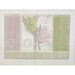
Le due Repubbliche . . . la Confederazione Peruviana . . . Bolivia . . .
A rare and detailed double-page map of Peru and Bolivia. Map is surrounded by an explanatory historical text about the countries in pink, yellow and green background colo...
- $100 / ≈ €94
Place & Date: Venice, 1840
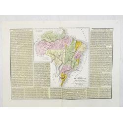
Impero Brasiliano . . .
A rare and detailed double-page map of Brazil. Map is surrounded by an explanatory historical text about the countries in a yellow background color.According to the title...
- $100 / ≈ €94
Place & Date: Venice, 1840
![[Gauchos near Buenos Aires in Argentina ].](/uploads/cache/27323-250x250.jpg)
[Gauchos near Buenos Aires in Argentina ].
Aquatint depicting some Gauchos cooking and relaxing near Buenos Aires. Engraved by Bonatti.From Giulio Ferrario's work Le Costume Ancien et Moderne ou Histoire du gouv...
- $75 / ≈ €70
Place & Date: Milan, 1827
![[ Soldiers near the river banks of the River Plate ].](/uploads/cache/27324-250x250.jpg)
[ Soldiers near the river banks of the River Plate ].
Aquatint depicting soldiers living near the river banks of the River Plate, an estuary formed by a combination of Uruguay rivers and the Parana River. It is located at th...
- $75 / ≈ €70
Place & Date: Milan, 1827
![[ A square at Buenos Aires. ]](/uploads/cache/27329-250x250.jpg)
[ A square at Buenos Aires. ]
Aquatint depicting a suare at Buenos Aires.Engraved by Fumigalli.From Giulio Ferrario's work Le Costume Ancien et Moderne ou Histoire du gouvernement, de la milice, de la...
- $75 / ≈ €70
Place & Date: Milan, 1827
![[ Market Place at Buenos Aires. ]](/uploads/cache/27330-250x250.jpg)
[ Market Place at Buenos Aires. ]
Aquatint depicting a lifely scene of the Market Place Buenos Aires with its merchants.Engraved by Fumigalli.From Giulio Ferrario's work Le Costume Ancien et Moderne ou Hi...
- $75 / ≈ €70
Place & Date: Milan, 1827
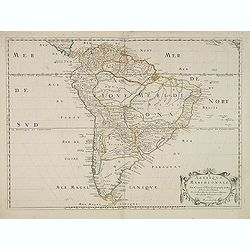
Amerique méridionale. . .
Detailled map of South America from his "Atlas Universel".Gilles Robert de Vaugondy (1688–1766), also known as Le Sieur or Monsieur Robert, and his son, Didie...
- $150 / ≈ €140
Place & Date: Paris, 1750
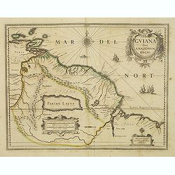
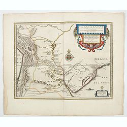
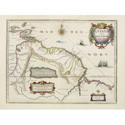
Guiana sive Amazonum Regio.
Nice map extending from the Isla Margarita in the northwest to the coast of northern Brazil near Sao Luis east of the Amazon delta. The map locates at its center a large ...
- $500 / ≈ €468
Place & Date: Amsterdam, 1640
Carte du Bresil le Perou. . .
Scarce map of Northern part of South America with Venezuela, Colombia, Brazil and Peru, prepared by Nolin and published by L.J. Mondhare for his Atlas Général a l'usage...
- $125 / ≈ €117
Place & Date: Paris, 1781
Amerique Meridionale. Par N.Sanson d'Abbeville. . .
The first edition of a cornerstone South America map, the first to show the boundaries of many countries, regions, and provinces. Peru is shown governing a huge tract of ...
- $500 / ≈ €468
Place & Date: Paris, after 1650
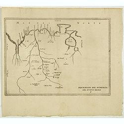
Descripcion del audiencia del Nuevo Reino 9.
The earliest map to include information from the previously secret manuscript maps of the Spanish cosmographer, Juan López de Velasco, showing present-day Colombia and V...
- $450 / ≈ €421
Place & Date: Amsterdam, Michel Colin, 1622
Guiana sive Amazonum Regio.
A very decorative map of Suriname which extends from the Isla Margarita in the northwest to the coast of northern Brazil near Sao Luis east of the Amazon delta. The map l...
- $450 / ≈ €421
Place & Date: Amsterdam, 1658
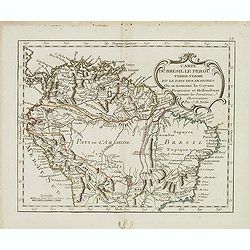
Partie Orientale de la Terre Ferme ou l'on trouve la Guiane.
Nice small map encompassing a large area between the Orinoco and the River Amazon.From Atlas Portatif Universel, by Robert de Vaugondy.Page 107 outside border top right. ...
- $75 / ≈ €70
Place & Date: Paris, later than 1749
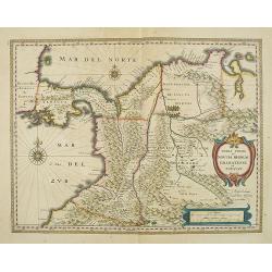
Terra Firma et Novum regnum Granatense et Propayan.
Fine copy, with wide margins of this handsome map of the Isthmus of Panama and northwestern South America including most of present day Columbia and part of Venezuela. Te...
- $400 / ≈ €374
Place & Date: Amsterdam, 1640
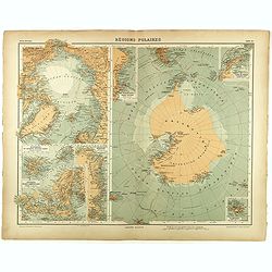
Régions Polaires.
Eight maps on one sheet, showing the North and South Poles, with adjective regions. Taken from "Atlas Universel" by Chesneau and Ch. Bonnesseur. Engraved by R. ...
- $50 / ≈ €47
Place & Date: Paris, 1931
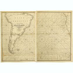
A general chart of the South Atlantic Ocean Drawn by J.W.Norie hydrographer. Revised & Corrected 1854.
A 2-sheet chart of the South Atlantic Ocean, showing the coast of South America from the mouth of the Amazon to Quito in Peru. The right hand part showing Africa's coast ...
- $600 / ≈ €561
Place & Date: London, 1854
Nouvelle carte de geographie de .. Meridionale de l'Amerique
Chatelain's map of South America. The title is in two lines across the map. The tracks of Magellan, de la Maire, de Mendana, etc. are shown.On each side, borders appear a...
- $250 / ≈ €234
Place & Date: Amsterdam, 1719
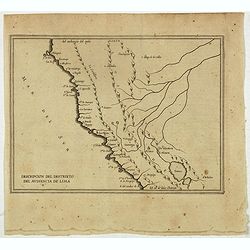
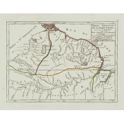
Descripcion Del Destrieto Del Audiencia De Lima. (Peru, and parts of Colombia, and Brazil)
Rare early map of the Audiencia of Lima, locating rivers and settlements, the earliest map to include information from the previously secret manuscript maps of the Spanis...
- $475 / ≈ €444
Place & Date: Amsterdam, Michel Colin, 1622
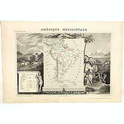
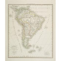
Amerique Meridionale.
A very decorative 19th century map of the continent colored to show political divisions. The map is surrounded by fully colored, steel engraved scenes including horses, I...
- $150 / ≈ €140
Place & Date: Paris, 1850
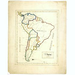
S America by Mas T.J. Sackels.
Pen and ink on card board. Map of South America drawn by T.J.Shackels. Probably a school exercise.
- $120 / ≈ €112
Place & Date: England, ca. 1900