Browse Listings in America > Caribbean & Atlantic Ocean > Atlantic ocean general
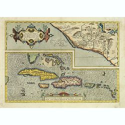
Culiacanae Americae regionis.. / Hispaniolae, Cubae..
Two separate virtually identically sized inset maps on one sheet, each with a decorative scroll title cartouche. Culiacanae depicts the coastal and inland western region...
- $1200 / ≈ €1123
Place & Date: Antwerp 1598
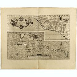
Culiacanae Americae regionis.. / Hispaniolae, Cubae..
Two virtually identically sized inset maps on one sheet, each with a decorative scroll title cartouche. Culiacanae depicts the coastal and inland western region in North ...
Place & Date: Antwerp, 1598
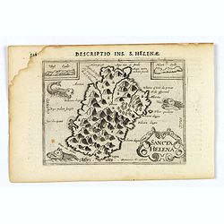
Sancta Helena.
An attractive small map of the south Atlantic island of St. Helena. Two years after the publication of Linschoten's Itinerario, the first map of St. Helena appeared in 15...
- $100 / ≈ €94
Place & Date: Amsterdam, 1606

Pascaerte van Brazil en Nieu Nederlandt van Cuorvo en Flores.
A rare chart of the Atlantic Ocean from the first edition of Hendrick Doncker's Zee-Atlas, of which no surviving example is known.Although the idea of its unusual coverag...
Place & Date: Amsterdam, 1658

Pascaerte vande Vlaemsche, Soute, en Caribesche Eylanden, als mede Terra Nova,. . .
This fine and scarce sea chart covers the central Atlantic and extends to include the Maritime Provinces, Antilles and the northwest coast of South America, east to the A...
Place & Date: Amsterdam, 1672

Recueil de divers voyages faits en Afrique et en l'Amerique, qui n'ont point esté encore publiez.
First edition of this collection of significant and interesting voyages, edited by a scholar and book collector who served in the employ of Louis XIV before being appoint...
Place & Date: Paris, Louis Billaine, 1674
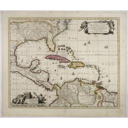
Insulae Americanae in Oceano Septentrionali..
A particularly handsome map portraying the south-eastern U.S., the Caribbean islands, part of Mexico, Central America, Florida (called tegesta Prov. ) and part of South A...
- $1500 / ≈ €1404
Place & Date: Amsterdam, 1702

Nieuwe Wassende Graade Zee Kaart over de Spaanse Zee Vant Kanaal tot 't Eyland Cuba in Westindia. . .
¤ Engraved by I.van Anse. A very representative example of a Dutch chart of the Atlantic, showing the north-east coast of America, the coasts of Africa and Europe and So...
Place & Date: Amsterdam, 1728

Nieuwe Wassende Graadige Pas-kaart van de Kust van Guinea en Brasilia.
Rare two-sheet sea chart of the coasts of Brazil, West Africa and South Africa, published by Johannes Van Keulen (the younger), circa 1720.The chart shows the western coa...
Place & Date: Amsterdam, 1751

Nieuwe Wassende Graade Zee Kaart over de Spaanse Zee Vant Kanaal tot 't Eyland Cuba In Westindia.
Rare two-sheet blue-back sea chart of the Atlantic and Eastern part of North America., published by Gerard Van Keulen. The map extends from the latitude of Newfoundland a...
- $2000 / ≈ €1871
Place & Date: Amsterdam, ca. 1728-1751
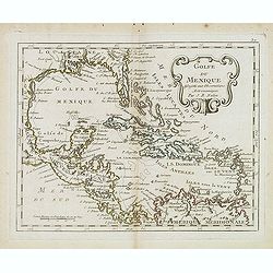
Golfe du Mexique Assujetti aux Observations Astronomiques Par J.B.Nolin.
Rare map of the Caribbean prepared by J.B.Nolin and published by L.J. Mondhare for his Atlas Général a l'usage des colleges et maisons d'education.. Louis Joseph Mondha...
- $200 / ≈ €187
Place & Date: Paris, 1781
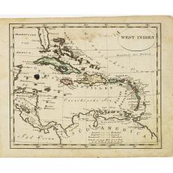
West indien.
Nice small map of The West Indies, with Cuba, Jamaica, S.Domingo, etc. Southern tip of Florida is included. Map by Johannes Walch in his rare Allgemeiner Atlas Nach den b...
- $150 / ≈ €140
Place & Date: Augsburg, 1812
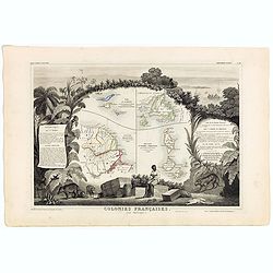
Colonies Françaises (en Amérique). N°92.
A very decorative 19th century map showing the islands of St Martin, St Pierre et Miquelon and Terra Nova. Includes also Guyana. The map is surrounded by portraits, anima...
Place & Date: Paris, A. Combette, 1852
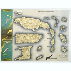
BWIA. North America - Caribbean Route Map.
An interesting double-sided brochure-type map of the routes flown by BWIA (British West Indian Airlines) between North America and the Caribbean. One side shows (not in t...
- $110 / ≈ €103
Place & Date: USA, ca 1960-1965