Browse Listings in America > Caribbean & Atlantic Ocean

Nieuwe Wassende Graade Zee Kaart over de Spaanse Zee Vant Kanaal tot 't Eyland Cuba In Westindia.
Rare two-sheet blue-back sea chart of the Atlantic and Eastern part of North America., published by Gerard Van Keulen. The map extends from the latitude of Newfoundland a...
- $2000 / ≈ €1871
Place & Date: Amsterdam, ca. 1728-1751
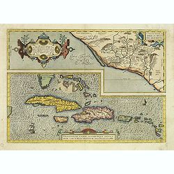
Culiacanae Americae regionis.. / Hispaniolae, Cubae..
Two separate virtually identically sized inset maps on one sheet, each with a decorative scroll title cartouche. Culiacanae depicts the coastal and inland western region...
- $1200 / ≈ €1123
Place & Date: Antwerp 1598
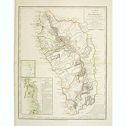
Carte de la Dominique Prise par les Francois le 7 Septembre 1778. Avec le Plan du Debarquement et de l'Attaque des Forts et Batteries par les Troupes et Les Fregates de sa Majeste
A rare map of St. Dominica, with insets of Charlotteville with its attack by the French on 7 September 1778 on the British. Also small inset map of the Caribbean islands ...
- $500 / ≈ €468
Place & Date: Paris, 1778

Recueil de divers voyages faits en Afrique et en l'Amerique, qui n'ont point esté encore publiez.
First edition of this collection of significant and interesting voyages, edited by a scholar and book collector who served in the employ of Louis XIV before being appoint...
Place & Date: Paris, Louis Billaine, 1674