Browse Listings in Africa > North Africa

De Cust van Barbaria, Gualata, Arguyn, en Gene..heo, van Capo S.Vincente tot Capo Verde.
An eye-catching chart of the north western coast of Africa. Including Canary Islands, Cape Verde Islands and Azores.Pieter Goos (ca. 1616-1675) was one of the most import...
Place & Date: Amsterdam, 1666
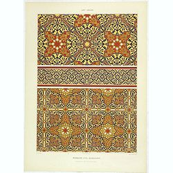
Art arabe. - Mosquée d'El-Bordeyny.
Lithographed by Daumont. From the author's "L'Art Arabe d'après les monuments du Kaire...". Emile Prisse d'Avennes, Orientalist and Muslim convert, obsessive i...
Place & Date: Paris, 1877

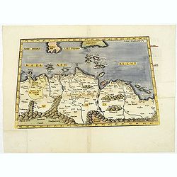
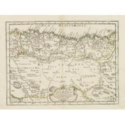
De Cust van Barbaryen van out Mamora tot Capo Blanco..
Six charts on one sheet. The two upper charts covering an area from Cape Blanc to Casablanca. In lower part four insets with detailed charts of islands as Madera, Porto S...
Place & Date: Amsterdam, 1666

.Tabu nova partis Aphri.
Based on Waldseemüller's map. The maps show Northern Africa as it was known to Europeans at the first part of the 16th century. There is great details across north Afric...
Place & Date: Lyons, M. Servetus, 1535
.Aphricae Tabula secunda continet.
An important early map of the northern coast of Africa and including parts of the islands of Sicily and Sardine.
Place & Date: Vienne, 1541
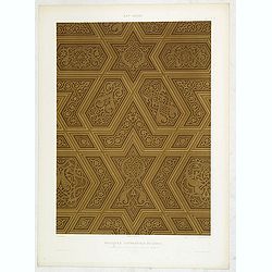
Art arabe. - Mosquée cathédrale de qous assemblage & détails des pièces du mimbar. . .
Lithographed by Daumont. From the author's "L'Art Arabe d'après les monuments du Kaire…". Emile Prisse d'Avennes, Orientalist and Muslim convert, obsessive i...
Place & Date: Paris, 1877
Art arabe. - Séances de Hariry.
Lithographed by Daumont. From the author's "L'Art Arabe d'après les monuments du Kaire…". Emile Prisse d'Avennes, Orientalist and Muslim convert, obsessive i...
Place & Date: Paris, 1877
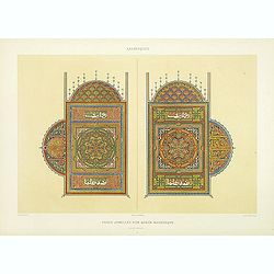
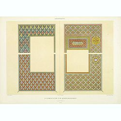
Arabesques. - Pages jumelles d'un qorân mauresque. (XVIIIe siècle)
Lithographed by Daumont. From the author's "L'Art Arabe d'après les monuments du Kaire…". Emile Prisse d'Avennes, Orientalist and Muslim convert, obsessive i...
Place & Date: Paris, 1877
Monument Sépulcral près de Kymân El-Gyouchy. (XVIIIe. siècle)
Highly decorative lithography by Asselineau, representing a mausoleum. From the author's "L'Art Arabe d'après les monuments du Kaire?". Emile Prisse d'Avennes,...
Place & Date: Paris, 1877

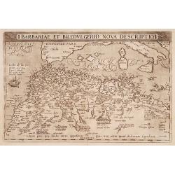
Barbariae et Biledulgerid, nova descriptio.
North-West Africa. Koeman speculated: "In view of the important trading relationship between Antwerp and Africa, it is not impossible that the original was a manuscr...
Place & Date: Antwerp, 1598
Carte de La Barbarie de La Nigritie et de la Guinée.
A detailed engraved map of north west Africa including the Canary and Cape Verde Islands. Engraved by Inselin. Address and date changed, now with the imprint "A Pari...
Place & Date: Paris, 1781
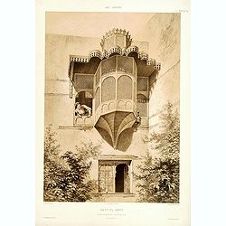
Beyt El-Emyr.
Lithograph by Mouilleron representing a young woman looking over a beautiful moucharabieh. From the author's "L'Art Arabe d'après les monuments du Kaire?". Emi...
Place & Date: Paris, 1877
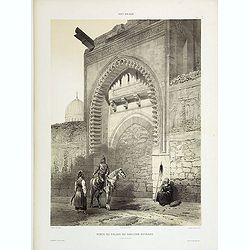
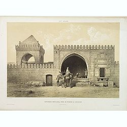
Porte du Palais du Soultan Beybars. (XIIIe. siècle)
Highly decorative lithography by Ch. Fichot, showing the walled-up entrance of Sultan Beybars' palace. From the author's "L'Art Arabe d'après les monuments du Kaire...
Place & Date: Paris, 1877
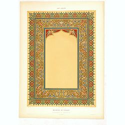
Arabesques. - Ornementation d'un Qoran Mauresque (XVIIIe siècle)
Lithographed by Daumont. From the author's "L'Art Arabe d'après les monuments du Kaire…". Emile Prisse d'Avennes, Orientalist and Muslim convert, obsessive i...
Place & Date: Paris, 1877
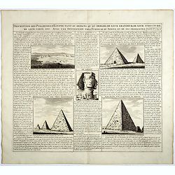
Description des piramides d'Egypte tant au départ qu'au dehors . . .
Engraved text page with 5 views of the pyramids and an image of the Sphinx. From Chatelain's monumental 7 volume "Atlas Historique".Henri Abraham Chatelain (168...
- $36 / ≈ €34
Place & Date: Amsterdam, 1720
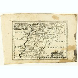
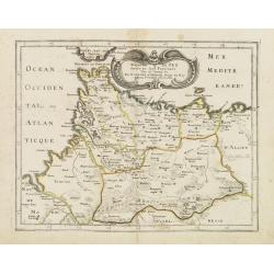
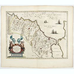
Le Royaume de Marroc.
Rare map of Morocco published by Jollain in 1667. Published in "Trésor Des Cartes Geographiques Des Principaux Estats de Lunivers".This atlas is based upon Boi...
- $100 / ≈ €94
Place & Date: Paris, 1667
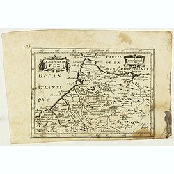
Le Royaume de Fez.
Rare map of Morocco published by Jollain in 1667. Published in "Trésor Des Cartes Geographiques Des Principaux Estats de Lunivers".This atlas is based upon Boi...
- $150 / ≈ €140
Place & Date: Paris, 1667
Barbarie.
Rare map of the Barbary Coast of Africa published by Jollain in 1667. Published in "Trésor Des Cartes Geographiques Des Principaux Estats de Lunivers".This atl...
- $100 / ≈ €94
Place & Date: Paris, 1667
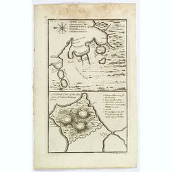
Charta exhibens Situm antiquum Carthaginis, Uticae. . . / A Bird's View of the Situation of Antient Carthage.
A pair of engravings of ancient Carthage in North Africa, from Charles Rollins' "The Ancient History of the Egyptians, Carthaginians, Assyrians, Babylonians, medes &...
- $50 / ≈ €47
Place & Date: London, ca 1768
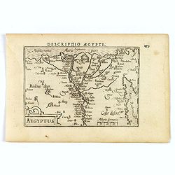
Aegyptus.
A fine miniature map of Egypt, published by Petrus Bertius in Amsterdam early in the seventeenth century. The lovely map and has a strap-work title, in the lower left cor...
- $100 / ≈ €94
Place & Date: Amsterdam, 1606
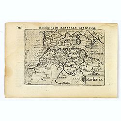
Barbaria.
A nice miniature map of the north African region known as 'Barbary', published by Petrus Bertius in Amsterdam early in the seventeenth century. This lovely map also depic...
- $100 / ≈ €94
Place & Date: Amsterdam, 1606
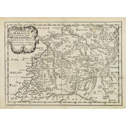
'T Koninkryk van Marocco, verdeelt in Zeven Landschappen, enz. . .
A Dutch edition of this finely engraved map of Morocco filled with mountain ranges, oases and cities. The map is adorned with a decorative cartouche.
- $90 / ≈ €84
Place & Date: Amsterdam, ca. 1705
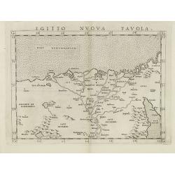
Egitto nuova tavola.
Fine early map of Egypt and the Nile delta. Extends east to the Upper Red Sea and West to "Deserto De Marmarica". Nice detail in the lower Nile regions. Page ta...
- $200 / ≈ €187
Place & Date: Venice, 1561
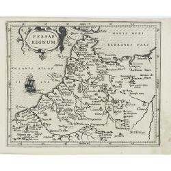
Fessae Regnum.
Charming small map of the northwestern tip of Africa with Fez showing as the principal city. Decorative title cartouche.From a Latin-text edition of Jodocus Hondius' Atla...
- $120 / ≈ €112
Place & Date: Amsterdam, 1608
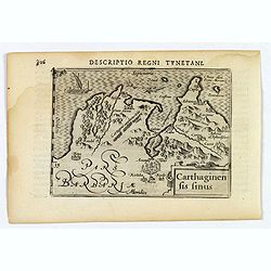
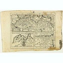
Carthaginensis Sinus.
A beautifully miniature map by Petrus Bertius of the ancient city of Carthage and the more modern town of Tunis, first published in 1598. There are numerous features tha...
- $100 / ≈ €94
Place & Date: Amsterdam, 1606
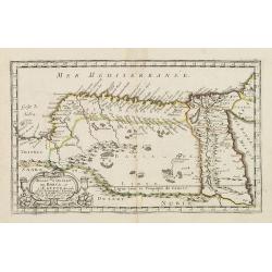
Royaume et desert de Barca, et Aegypte divisee. . .
Map of Egypt prepared by N.Sanson and published by Pierre Mariette.Published in an early edition of the small Sanson atlas L'Europe Dediée a Monseigneur . . . Le Tellier...
- $100 / ≈ €94
Place & Date: Paris, P. Mariette, 1667
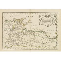
Partie de la Barbarie ou sont les royaumes de Tunis et Tripoli. . .
Coastal map of Tunisia and Libya prepared by N.Sanson and published by Pierre Mariette.Published in an early edition of the small Sanson atlas L'Europe Dediée a Monseign...
- $750 / ≈ €702
Place & Date: Paris, P. Mariette, 1667
Royaume de Fez. . .
Map of Morocco prepared by N.Sanson and published by Pierre Mariette.Published in an early edition of the small Sanson atlas L'Europe Dediée a Monseigneur . . . Le Telli...
- $120 / ≈ €112
Place & Date: Paris, P. Mariette, 1667
Partie de la Barbarie ou est le royaume d'Alger. . .
Coastal map of North Africa prepared by N.Sanson and published by Pierre Mariette.Published in an early edition of the small Sanson atlas L'Europe Dediée a Monseigneur ....
- $80 / ≈ €75
Place & Date: Paris, P. Mariette, 1667
Bocche del Fiume Negro et Isole di Capo Verde. . .
This is a splendid map of the northwestern coast of Africa and the Cape Verde Islands.The map provides details of the various Portuguese discoveries in the region in the ...
- $600 / ≈ €561
Place & Date: Venice, 1696
Barbariae et Biledulgerid, nova descriptio.
North-West Africa. Koeman speculated: In view of the important trading relationship between Antwerp and Africa, it is not impossible that the original was a manuscript ma...
- $300 / ≈ €281
Place & Date: Antwerp, 1587
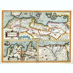
Barbaria. / Egypt / Tunesia.
Three maps on one sheet. Upper part, it shows the coast of Barbaria from Morocco to Egypt: the map on the left corner of Tunis includes a plan of Goletiae, and the right ...
- $300 / ≈ €281
Place & Date: Amsterdam, 1641

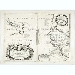
.Caarte voor een gedeelte der Canarise Eylanden als Canaria, Tenerifa, Forteventura, etc.
Very rare chart of the Canaries. Showing Palma, Ferro, Tenerife, Gran Canaria, Forteventura, Lancerota. In upper right hand corner inset of harbour of Lancerota.
- $1000 / ≈ €936
Place & Date: Amsterdam, 1666
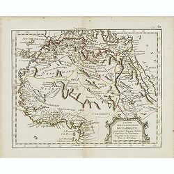
Partie septentrionale de l'Afrique contenant l'Egipte. . .
Scarce map of northern part of Africa, prepared by Nolin and published by L.J. Mondhare for his Atlas Général a l'usage des colleges et maisons d'education.. Louis Jose...
- $150 / ≈ €140
Place & Date: Paris, 1783
![Tabula IIII Aphricae. [with Prester John]](/uploads/cache/42945-250x250.jpg)
Tabula IIII Aphricae. [with Prester John]
Early Ptolemaic woodcut map of the regions of Africa that were known to the ancients. The twin lake sources of the Nile are located near the Mons Lune (Mountains of the M...
- $950 / ≈ €889
Place & Date: Vienna, 1522- 1535

Natoliae.. Aegypti recentior.. Carthaginis ( 3 maps on 1 sheet)
Three maps on one sheet. Map to the left east to the top. Detailed map Turkey, including Cyprus and Crete. Also map of the Nile delta and another map of Tunis. From "...
- $750 / ≈ €702
Place & Date: Antwerp, 1587
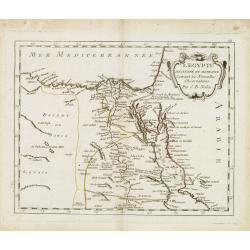
L'Egypte. . .
Scarce map of Egypt, prepared by Nolin and published by L.J. Mondhare for his Atlas Général a l'usage des colleges et maisons d'education.. Louis Joseph Mondhare was ac...
- $75 / ≈ €70
Place & Date: Paris, 1783
Fezzae et Marocchi regna Africae celeberrima.
North to the right. Showing the Atlas Mountains in the south to the southern coast of Spain, along the coast at Ceuta, Tangiers, and Arzilla.A finely engraved, decorative...
- $650 / ≈ €608
Place & Date: Amsterdam, 1644
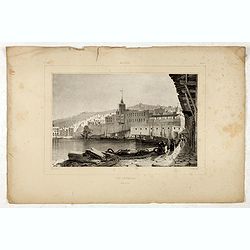
Alger Vue générale prise du port.
Decorative lithography taken from "Voyage pittoresque dans la régence d'Alger" printed in 1835 by Charles Motte. Prepared by WYLD William Wyld (1806-1889) and ...
- $40 / ≈ €37
Place & Date: Paris, 1835
![Red Sea - Strait of Jubal.. [2838]](/uploads/cache/23496-250x250.jpg)
Red Sea - Strait of Jubal.. [2838]
Large chart focused on the Strait of Jubal in the Gulf of Suez. With the Juzur Tawilah Islands at the center and an inset plan of the Tur Harbour (At Tur, South Sinai) o...
- $500 / ≈ €468
Place & Date: London (1853) corrected for 1862