
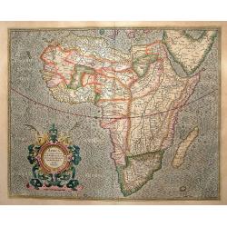
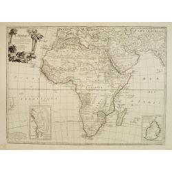
Nova Africa descriptio.
A beautifully engraved and most attractive "carte à figures"- map of the African continent. Bordered, above, by panels showing panorama's of Cairo, Alexandria,...
Place & Date: Amsterdam, after 1660
Africa ex magna orbis terre descriptione Gerardi Mercator. . .
Map of Africa. Much of the interior of Africa defers to the traditions of Ptolemy. The Nile river is shown with the two lakes and the Mountains of the Moon across souther...
Place & Date: Amsterdam, 1630
Selling price: $1500
Sold in 2015
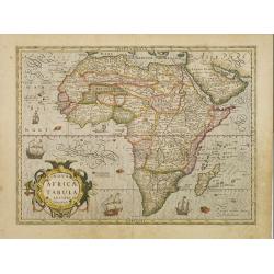
Nova Africae Tabula.
An attractive map of the continent, added by Hondius when he took over publication of Mercator's Atlas. Although it is based on Mercator's map, Hondius improved the outli...
Place & Date: Amsterdam, 1630
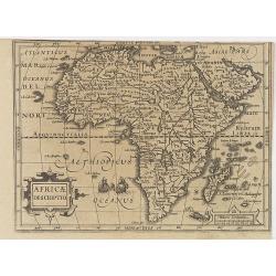
Africae Descriptio.
Map of Africa from the first French-text edition of Jodocus Hondius' Atlas Minor.Shortly after the publication of the big folio-atlases the need was apparently felt for a...
Place & Date: Amsterdam, 1608
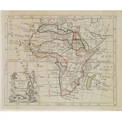
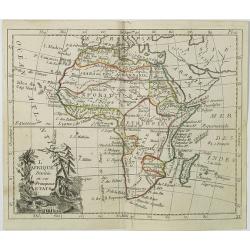
L'Afrique Divisée en ses Principaux Etats.
Map of Africa, from Atlas de la Géographie de toutes les parties du monde.. Ouvrage destiné pour l'education, et nécessaire aux négocians, aux voyageurs, aux fonction...
Place & Date: Paris, Prudhomme, Levrault, Debray, 1806
L'Afrique divisée en ses principaux Etats assujettie..
Excellent copper engraved map of the continent showing the extent of knowledge in the mid-18th century.While mostly accurate, it does have remnants of fantasy such as the...
- $400 / ≈ €374
Place & Date: Venice, 1776 - 1784

Africa juxta navigationes et observat recentissimas. . .
Miniature map of Africa, a reduction of the Seutter folio map based on Homann''s cartography of 1715. Very detailed - much of it fictitious. The Nile is shown not only or...
Place & Date: Augsburg, J.M.Will, 1778
L'Afrique . . .
Map of the African continent, from Atlas moderne portatif composé de vingt-huit cartes sur toutes les parties du globe terrestre .. A l'usage des Colléges, des Pensions...
- $200 / ≈ €187
Place & Date: Paris, Prudhomme, Levrault, Debray, 1806

Carte d'Afrique Dressée pour l'instruction par Guillaume DeLisle. . .
The map is a rare re-issue of the Delisle map of 1722. In his first map of the continent in 1700, Delisle re-measured the Mediterranean, being the first to establish its ...
Place & Date: Paris, J.Dezauche, 1819
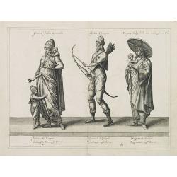
Femina indica Orientalis - Indus Africanus - Singava vulgo dicta sive erratica femina Ori.
Beautiful engraving by Abraham de Bruyn showing inhabitants of Asian and African people with captions in Latin, French and German.Abraham de Bruyn, a Flemish engraver and...
Place & Date: Cologne, c.1577