Browse Listings in Africa
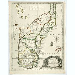
Isle D'Auphine, communement Nommée pae les Europeens Madagascar. . .
One of the most UpToDate maps of Madagascar, also showing the Comoros Islands in the North West and the Reunion Island in the South East.With decorative title cartouche r...
- $900 / ≈ €842
Place & Date: Paris, 1667
![Loandas St.Paulo [Luanda]](/uploads/cache/48500-250x250.jpg)
Loandas St.Paulo [Luanda]
Engraved by Thomas Doesburgh (active between 1683 and 1714) for Carolus Allard's for his Orbis habitabilis oppida et vestitus the print shows a distance view of the Angol...
- $150 / ≈ €140
Place & Date: Amsterdam, c.1685-1690
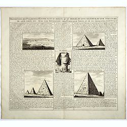
Description des piramides d'Egypte tant au départ qu'au dehors . . .
Engraved text page with 5 views of the pyramids and an image of the Sphinx. From Chatelain's monumental 7 volume "Atlas Historique".Henri Abraham Chatelain (168...
- $36 / ≈ €34
Place & Date: Amsterdam, 1720
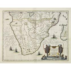
Aethiopia inferior, vel exterior.
The standard map of South Africa throughout the 17th century. The lake out of which the 'Zambere' -the Zambesi- flows is probably based on reports of Lake Ngami, undiscov...
- $575 / ≈ €538
Place & Date: Amsterdam, 1645
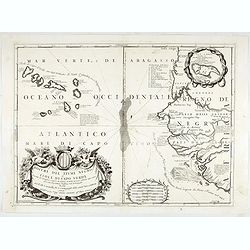
Bocche del Fiume Negro et Isole di Capo Verde. . .
This is a splendid map of the northwestern coast of Africa and the Cape Verde Islands.The map provides details of the various Portuguese discoveries in the region in the ...
- $600 / ≈ €561
Place & Date: Venice, 1696
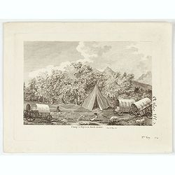
Camp à Duywen Hock Riviere. (Tom.1er. Pag.131.)
Camp Duywen Hock River engraved view, from Francois Levaillant’s Voyage dans l’interieur de l’Afrique. Text in French reads “Tom. 1er. Pag. 131. Atlas pl. 5. 1er ...
- $250 / ≈ €234
Place & Date: Paris, 1798
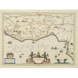
Guinea.
An attractive map covered with intersecting rhumb lines and decorated with monkeys, lions, elephants and native figures. With a dedication to Dr. Nicolas Tulp.As Willem B...
- $750 / ≈ €702
Place & Date: Amsterdam, 1638
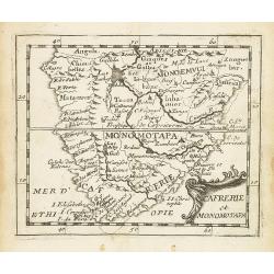
Cafrerie et Monomotapa.
Uncommon miniature map of South Africa from Pierre Duval's "La Geographie Universeille" dated 1676. Following his Cartes de géographie in 1657, Pierre Duval pu...
- $150 / ≈ €140
Place & Date: Paris, 1676
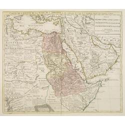
Carte de l'Egypte de la Nubie de l'Abissinie. . .
Detailed copper-engraved map of North-East Africa showing Guinea in the southwest through Ethiopia , the Red Sea to the Persian Gulf.In the northwest, Tunis through Egypt...
- $250 / ≈ €234
Place & Date: Amsterdam, 1745
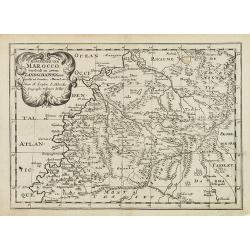
'T Koninkryk van Marocco, verdeelt in Zeven Landschappen, enz. . .
A Dutch edition of this finely engraved map of Morocco filled with mountain ranges, oases and cities. The map is adorned with a decorative cartouche.
- $90 / ≈ €84
Place & Date: Amsterdam, ca. 1705