Browse Listings in Africa
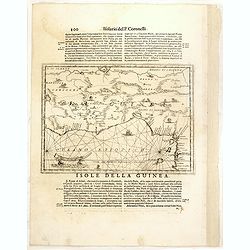
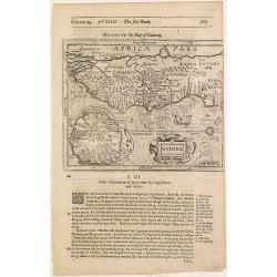
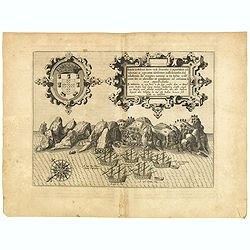
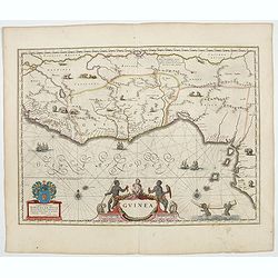
Isola della Guinea. / Isola Gore.
Fine map of Guinea, from Isolario Dell'Atlante Vento.On verso a map of the island Goeree (130x172mm). The sheet dimension is 485x350mm
- $300 / ≈ €281
Place & Date: Venice, 1690
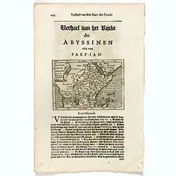
Abissinorum Imperium. / Acomath .I. Turcarum Imperator .XIIX. Ex Stirp. Ottomannica.
Map of central Africa. Copperplate engraving on text leaf with letterpress on verso. The engraving depicts a half length oval portrait of "Acomath I".Nicolaes d...
Place & Date: Amsterdam, Cloppenburch, 1621
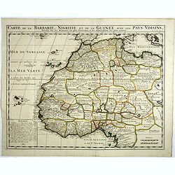
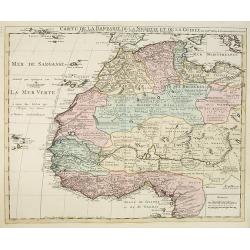
Carte de la barbarie, Nigritie et de la Guinée avec les pays voisins . . .
This great map of western Africa is based on Guillaume Delisle's map. It covers from the Barbary coast to below the equator. There is a mass of geographic detail and nota...
- $300 / ≈ €281
Place & Date: Amsterdam, 1720
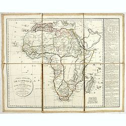
Carte générale de L'Afrique divisée en ses principaux états par Fx Delamarche. . .
Uncommon map of Africa prepared by Felix Delamarche, after R.de Vaugondy. The "Zahara ou Grand désert" and Congo and Zambia "Contrée tout-a-fait Inconnue...
- $300 / ≈ €281
Place & Date: Paris, 1820
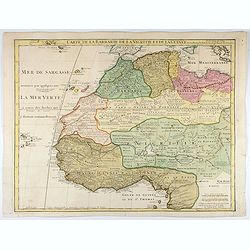
Carte de La Barbarie de La Nigritie et de la Guinée.
A detailed engraved map of north west Africa including the Canary and Cape Verde Islands. Engraved by Inselin. Address and date changed, now with the imprint "A Pari...
Place & Date: Paris, 1781
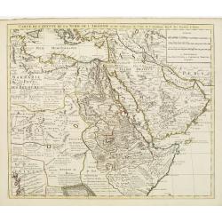
Carte de l'Egypte de la Nubie de L'Abissinie &c..
Detailed copper-engraved map of North-East Africa showing Guinea in the southwest through Ethiopia , the Red Sea to the Persian Gulf.In the northwest, Tunis through Egypt...
- $500 / ≈ €468
Place & Date: Amsterdam, c. 1745
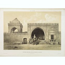
Monument Sépulcral près de Kymân El-Gyouchy. (XVIIIe. siècle)
Highly decorative lithography by Asselineau, representing a mausoleum. From the author's "L'Art Arabe d'après les monuments du Kaire?". Emile Prisse d'Avennes,...
Place & Date: Paris, 1877

Carte de L'Egypte de la Nubie de L'Abissinie..
Prepared by G.de l'Isle. Uncommon issue by Hendrik de Leth. Very detailed map of northeastern Africa, the Red Sea and the Arabian peninsula shows the political divisions ...
- $500 / ≈ €468
Place & Date: Amsterdam 1740
Carte de la Barbarie de la Nigritie et de la Guinée..
Richly engraved map of North and West Africa, based upon the earlier maps of De L'Isle. Richly annotated throughout and with excellent regional detail. It includes the Ca...
- $350 / ≈ €328
Place & Date: Amsterdam c. 1745
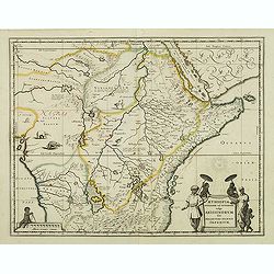
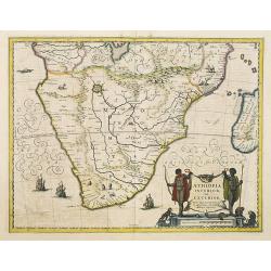
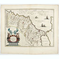
Aethiopia Superior vel Interior vulgo Abissinorum.
An attractive map of Eastern Africa and the fictitious kingdom of Prester John. The map shows a major section of central and eastern Africa including Mozambique north to ...
- $450 / ≈ €421
Place & Date: Amsterdam, 1638

Barbariae et Biledulgerid, nova descriptio.
North-West Africa. Koeman speculated: "In view of the important trading relationship between Antwerp and Africa, it is not impossible that the original was a manuscr...
Place & Date: Antwerp, 1598
Costes de L'Afrique .. ..Cap de Bone Esperance..
In the upper right-hand corner inset map of Saldanha Bay. Numerous place names, soundings and sand banks are shown round the island and the regions are defined by origina...
- $500 / ≈ €468
Place & Date: Amsterdam, 1720
![[Title in Ottoman Turkish: SOUTHERN AFRICA].](/uploads/cache/44732-250x250.jpg)
[Title in Ottoman Turkish: SOUTHERN AFRICA].
A fine Ottoman map of Southern Africa from Ali Şeref Paşa’s rare "Yeñi coġrafya aṭlası", published by the press of Matbaa-i Amire, the successor of İb...
- $350 / ≈ €328
Place & Date: Beyazit, Istanbul: Matbaa-i Amire 1311 or 1895
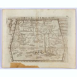
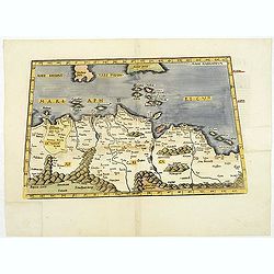
Tabula Africae IIII.
Gastaldi's map of the Northern Africa, based on Ptolemy. Showing all of the Mediterranean, Ethiopian Interior, the Red Sea, Egypt, the source of the Nile, Red Sea, Dead S...
- $400 / ≈ €374
Place & Date: Venice, 1548
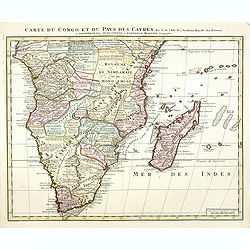
Carte du Congo et du Pays des Cafres. . .
Detailed copper-engraved map of southern Africa providing numerous particulars and comments concerning European trade, native kingdoms, and mineral wealth. Includes Madag...
Place & Date: Amsterdam, c. 1730
Ile de S. Laurens, ou Madagascar, située dans L'Ocean Ethiopien, sur les Côtes de L'Afrique.
Detailed map of Madagascar and Réunion. Published by Pieter van der Aa in "Galérie agréable du monde", completed in 1729. The Galerie was a sixty-six volume ...
- $450 / ≈ €421
Place & Date: Leiden, 1729
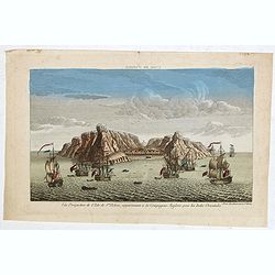
Vue perpective de l'Isle de St.Helene appartenant a la Compagnie Angloise pour les Indes Orientales.
Decorative optical view of St. Helena. The island is well-known as after the Royal Navy captured Napoleon Bonaparte, he was held hostage on the island until he died in 18...
- $300 / ≈ €281
Place & Date: Paris, 1780
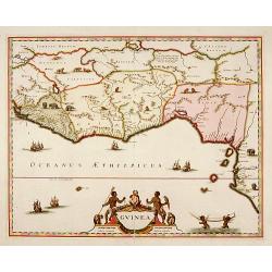
Guinea.
Samuel Purchas' edition of the Mercator/Hondius Atlas Minor . Map of Guinea published in his famous collection of voyages His Pilgrimes . With descriptive text in English...
Place & Date: London, 1645
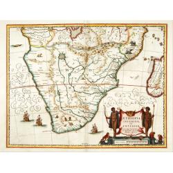
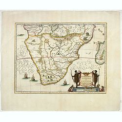
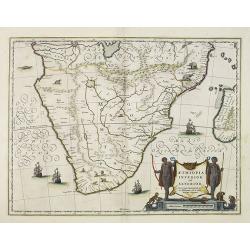
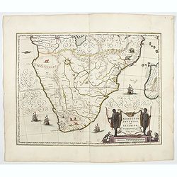
Aethiopia inferior, vel exterior.
The standard map of South Africa throughout the 17th century. The lake out of which the 'Zambere' -the Zambesi- flows is probably based on reports of Lake Ngami, undiscov...
- $575 / ≈ €538
Place & Date: Amsterdam, 1645
Ile de S. Laurens, ou Madagascar, située dans L'Ocean Ethiopien, sur les Côtes de L'Afrique.
Detailed map of Madagascar and Réunion. Published by Pieter van der Aa in "Galérie agréable du monde", completed in 1729. The Galerie was a sixty-six volume ...
- $450 / ≈ €421
Place & Date: Leiden, 1729
![[2 sheets] Carte particuliere de la Cote Occidentale de l'Afrique...](/uploads/cache/42917-250x250.jpg)
[2 sheets] Carte particuliere de la Cote Occidentale de l'Afrique...
A large 2 sheet map of a part of the west coast of Africa that covers The Gambia and Senegal. (When joined the map would measure approx. 1010 x 1400 mm) D'anville's maps ...
- $400 / ≈ €374
Place & Date: Paris, ca. 1751
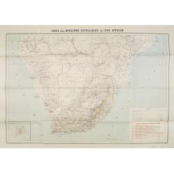
Carte des Missions Catholiques du Sud Africain.
Map of the Catholic Missions in South Africa. Inset map of L'Ile St. Hélène.Published as supplement of the Les Missions Catholiques. To the lower right an inset key to ...
Place & Date: Paris, Monrocq, 1902
Aethiopia Inferior vel Exterior.
The standard map of South Africa throughout the 17th century. The lake out of which the 'Zambere' -the Zambesi- flows is probably based on reports of Lake Ngami, undiscov...
- $750 / ≈ €702
Place & Date: Amsterdam, 1640
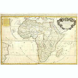
L'Afrique divisée en ses principaux Etats assujettie..
Excellent copper engraved map of the continent showing the extent of knowledge in the mid-18th century.While mostly accurate, it does have remnants of fantasy such as the...
- $400 / ≈ €374
Place & Date: Venice, 1776 - 1784
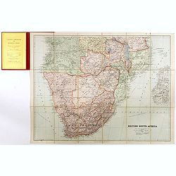
British South Africa.
With the signature of Alan Sillitoe (1928-2010), who was England’s best writer of proletarian fiction. From an early age, geography and maps were a very important part ...
- $450 / ≈ €421
Place & Date: London, 1923
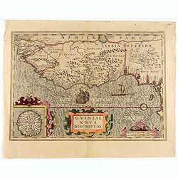
Guineae Nova Descriptio.
The map shows the West African coast from Senegal (the 'Rio Senega' is the Senegal River) to Cape Lopez on the Gulf of Guinea just below the equator.The island of St. Tho...
- $700 / ≈ €655
Place & Date: Amsterdam, 1628
.Aphricae Tabula secunda continet.
An important early map of the northern coast of Africa and including parts of the islands of Sicily and Sardine.
Place & Date: Vienne, 1541
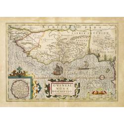
Guineae Nova Descriptio.
The map shows the West African coast from Senegal (the 'Rio Senega' is the Senegal River) to Cape Lopez on the Gulf of Guinea just below the equator. The island of St. Th...
- $450 / ≈ €421
Place & Date: Amsterdam, 1630

Pas-Caart van Guinea en den Custen daer aen gelegen Van C..
A decorative chart of the southwest coast of Africa, embellished with an elaborate, finely colored title-cartouche, and 2 compass-roses. Pieter Goos (ca. 1616-1675) was o...
Place & Date: Amsterdam, 1666

De Cust van Barbaria, Gualata, Arguyn, en Gene..heo, van Capo S.Vincente tot Capo Verde.
An eye-catching chart of the north western coast of Africa. Including Canary Islands, Cape Verde Islands and Azores.Pieter Goos (ca. 1616-1675) was one of the most import...
Place & Date: Amsterdam, 1666

De Cust van Barbaryen van out Mamora tot Capo Blanco..
Six charts on one sheet. The two upper charts covering an area from Cape Blanc to Casablanca. In lower part four insets with detailed charts of islands as Madera, Porto S...
Place & Date: Amsterdam, 1666
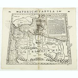
Aphricae Tabula I. (Mauritania - present-day Morocco, Algeria, and Tunisia.)
Double-page woodcut Ptolemaic-style map by Sebastian Münster figuring Mauritania, present-day Morocco, Algeria, and Tunisia, published in the edition of Strabo by Henri ...
Place & Date: Basle, Henri Petri, 1571
![Red Sea - Strait of Jubal.. [2838]](/uploads/cache/23496-250x250.jpg)
Red Sea - Strait of Jubal.. [2838]
Large chart focused on the Strait of Jubal in the Gulf of Suez. With the Juzur Tawilah Islands at the center and an inset plan of the Tur Harbour (At Tur, South Sinai) o...
- $500 / ≈ €468
Place & Date: London (1853) corrected for 1862
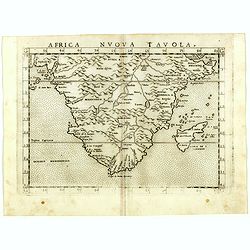
Africa nuova tavola.
Uncommon first edition of this early map of South Africa. Madagascar is called Isola de S. Lorenzo and is oddly shaped.The origin of the Nile conforms to the Ptolemaic co...
- $550 / ≈ €515
Place & Date: Venice, Vincenzo Valgrisi, 1561
Aethiopia inferior, vel exterior.
The standard map of South Africa throughout the 17th century. The lake out of which the 'Zambere' -the Zambesi- flows is probably based on reports of Lake Ngami, undiscov...
- $800 / ≈ €749
Place & Date: Amsterdam, ca. 1660
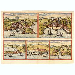
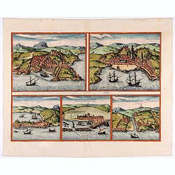
Tingis, Lusitanis, Tangiara. / Tzaffin. / Septa. / Arzilla/ Sala.
Views of the five northern and western African coastal town-view on one sheet: Latin text.From the greatest publication in this genre!. The Civitates was compiled and wri...
- $600 / ≈ €561
Place & Date: Cologne, 1580
Tingis, Lusitanis, Tangiara. / Tzaffin. / Septa. / Arzilla/ Sala.
Views of the five northern and western African coastal town-view on one sheet: Latin text.From the greatest publication in this genre!. The Civitates was compiled and wri...
- $600 / ≈ €561
Place & Date: Cologne, 1580
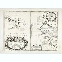
Bocche del Fiume Negro et Isole di Capo Verde. . .
This is a splendid map of the northwestern coast of Africa and the Cape Verde Islands.The map provides details of the various Portuguese discoveries in the region in the ...
- $600 / ≈ €561
Place & Date: Venice, 1696
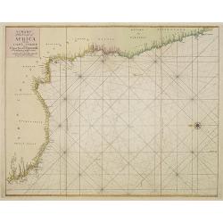
A chart of the coast of Africa from Cape Virde to Cape Bona Esperansa.
Rare and attractive chart of the western part of Africa.
- $800 / ≈ €749
Place & Date: London, 1748
Aethiopia inferior, vel exterior.
The standard map of South Africa throughout the 17th century. The lake out of which the 'Zambere' -the Zambesi- flows is probably based on reports of Lake Ngami, undiscov...
- $575 / ≈ €538
Place & Date: Amsterdam, 1645
L'Afrique divisée suivant l'estendue de ses principales parties ou sont distingués les vns des autres . . .
A second state of this fine mile-stone map of Africa with a decorative title and scale cartouche. As the title indicates, this map is based on the geography of Guillaume ...
- $750 / ≈ €702
Place & Date: Paris, 1685
Fezzae et Marocchi regna Africae celeberrima.
North to the right. Showing the Atlas Mountains in the south to the southern coast of Spain, along the coast at Ceuta, Tangiers, and Arzilla.A finely engraved, decorative...
- $650 / ≈ €608
Place & Date: Amsterdam, 1644

L'Enfance de Paul et Virginie.
Fine engraving of Paul and Virginie.Paul et Virginie (or Paul and Virginia) is a novel by Jacques-Henri Bernardin de Saint-Pierre, first published in 1787. The novel's ti...
Place & Date: Paris, ca. 1790

Natoliae.. Aegypti recentior.. Carthaginis ( 3 maps on 1 sheet)
Three maps on one sheet. Map to the left east to the top. Detailed map Turkey, including Cyprus and Crete. Also map of the Nile delta and another map of Tunis. From "...
- $750 / ≈ €702
Place & Date: Antwerp, 1587
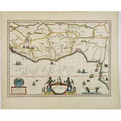
Guinea.
An attractive map covered with intersecting rhumb lines and decorated with monkeys, lions, elephants and native figures. With a dedication to Dr. Nicolas Tulp.
- $750 / ≈ €702
Place & Date: Amsterdam, 1640
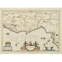
Guinea.
An attractive map covered with intersecting rhumb lines and decorated with monkeys, lions, elephants and native figures. With a dedication to Dr. Nicolas Tulp.As Willem B...
- $750 / ≈ €702
Place & Date: Amsterdam, 1638
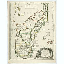
Isola di Madagascar o di S. Lorenzo Scoperta dà Portoghesi nell anno 1506. . .
A beautiful and flamboyantly engraved large-scale map of Madagascar, Bourbon and part of the coast of Mozambique. On verso a smaller map Madagascar (170x123mm) The map is...
- $650 / ≈ €608
Place & Date: Venice, ca. 1696
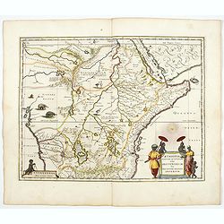
Presbiteri Johannis, sive Abissinorum Imperii descriptio.
Depicting Africa from the Mediterranean to the Mountains of the Moon placed just below Mozambique. Dare to go in Black. All early maps were printed in black and white,...
Place & Date: Antwerp, 1598
![[Map of Madagascar, Mauricius island and Réunion island, in Cyrillic ].](/uploads/cache/42567-250x250.jpg)
[Map of Madagascar, Mauricius island and Réunion island, in Cyrillic ].
A map of the south eastern coast of Africa and the island of Madagascar, comprehending 2 insets of the island of Bourbon (today Reunion) and Mauritius.The title appears i...
- $750 / ≈ €702
Place & Date: Paris / St.Petersburg, ca. 1790

Cimbebas et Caffariae Littora a Catenbela ad Promontorium. . .
The coast of Angola, South-West Africa and South Africa up to Port Elizabeth. Classic sea chart of Dutch school with excellent baroque embellishment. North oriented to th...
- $750 / ≈ €702
Place & Date: Amsterdam, 1675
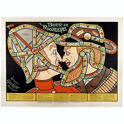
Boer-en Rooinekspel.
Design by E.G.Schlette. This is a board game similar to the famous "snakes and lessons". The game takes the players through various historical battles. Success ...
- $600 / ≈ €561
Place & Date: Amsterdam, Koster, ca. 1890
Insula D.Helenae sacra coeli Clementia . . .
A fine perspective view of the Island of St.Helena in the South Atlantic. The location of the Island directly on the navigation route from Europe to the Cape of Good Hope...
- $750 / ≈ €702
Place & Date: Frankfurt, 1609
Guinea.
An attractive map covered with intersecting rhumb lines and decorated with monkeys, lions, elephants and native figures. With a dedication to Amsterdam anatomist and phys...
- $750 / ≈ €702
Place & Date: Amsterdam, 1644

.Caarte voor een gedeelte der Canarise Eylanden als Canaria, Tenerifa, Forteventura, etc.
Very rare chart of the Canaries. Showing Palma, Ferro, Tenerife, Gran Canaria, Forteventura, Lancerota. In upper right hand corner inset of harbour of Lancerota.
- $1000 / ≈ €936
Place & Date: Amsterdam, 1666

Africa juxta navigationes et observat recentissimas. . .
Miniature map of Africa, a reduction of the Seutter folio map based on Homann''s cartography of 1715. Very detailed - much of it fictitious. The Nile is shown not only or...
Place & Date: Augsburg, J.M.Will, 1778
Aethiopia Superior vel Interior vulgo Abissinorum.
An attractive map of the Eastern African and the fictitious kingdom of Prester John. The map shows a major section of central and eastern Africa including Mozambique nort...
- $900 / ≈ €842
Place & Date: Amsterdam, 1644
Aethiopia inferior, vel exterior.
The standard map of South Africa throughout the 17th century. The lake out of which the 'Zambere' -the Zambesi- flows is probably based on reports of Lake Ngami, undiscov...
- $1000 / ≈ €936
Place & Date: Amsterdam, 1644

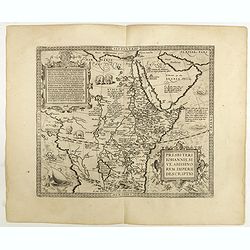
Carte de L\'Egypte de la Nubie de L\'Abissinie. . .
Prepared by G.de l'Isle. Uncommon issue by Hendrik de Leth. Very detailed map of northeastern Africa, the Red Sea and the Arabian peninsula shows the political divisions ...
Place & Date: Amsterdam, 1740
Guinea.
A close copy of the map by Blaeu. Covers the Guinea and Benin coast. A very decorative map with a large title cartouche. At bottom right two putti area carrying an elepha...
- $1100 / ≈ €1029
Place & Date: Amsterdam, 1680

Carte Particuliere d'une Partie d'Asie ou sont Les Isles D'Andemaon, Ceylan, Les Madives . . .
An impressive large sheet chart including the Red Sea, the coasts of Somali, Yemen, east coast of the Arabian peninsula. One of the early maps to focus on this area. Nume...
- $1000 / ≈ €936
Place & Date: Amsterdam, 1720
Isle D'Auphine, communement Nommée pae les Europeens Madagascar. . .
One of the most UpToDate maps of Madagascar, also showing the Comoros Islands in the North West and the Reunion Island in the South East.With decorative title cartouche r...
- $900 / ≈ €842
Place & Date: Paris, 1667
Genehoa Jaloffi et Sierraliones regna.
Decorative and detailed map of the West African Coast, from Senegal to Sierra Leone. In the center the river Gambia to the mouth in the Atlantic. Upper left a dedication ...
Place & Date: Amsterdam, 1670 / 1720
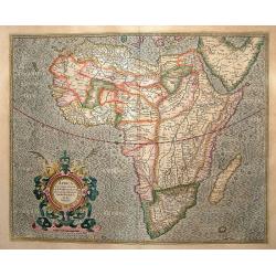
Africa ex magna orbis terre descriptione Gerardi Mercator. . .
Map of Africa. Much of the interior of Africa defers to the traditions of Ptolemy. The Nile river is shown with the two lakes and the Mountains of the Moon across souther...
Place & Date: Amsterdam, 1630
Selling price: $1500
Sold in 2015

Le cours entier du grand et Fameux Nil. . .
Scarce. A splendid map of ancient Egypt. West is at the top and the Nile bisects Egypt. A inset shows modern Egypt to good detail. With the Red Sea and part of the Arabia...
Place & Date: Augsburg, 1760

Plan du Cap de Bonne-Esperance et ses environs..
Large and detailed sea chart of the Cape of Good Hope from Saldahna Bay to False Bay.Engraved by Guillaume-Nicolas Delahaye (1727-1802).Latitude and longitude scales, com...
Place & Date: Paris, 1745

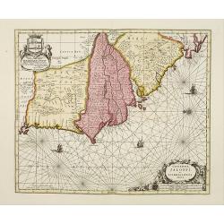
Paskaart van Guinea van C.Verde tot R. deGalion.
Rare edition of Doncker's sea chart of Guinea coast. From an atlas printed in 1668, "l'Atlas de MER ou MONDE AQUATIQUE, Remontrant toutes lescôtes de la Mer…"...
- $1000 / ≈ €936
Place & Date: Amsterdam, 1660-1668
Pascaart van de zee-custenvan Angola, en Cimbedas van Rivier de Galion tot C. de Bona Esperanca.
Rare Doncker's sea chart of the West Coast of Africa, from Angola to the Cape of Good Hope, with a larger inset map of the area from St. Martin's Bay to the Cape of Good ...
Place & Date: Amsterdam, 1660-1668
![Tabula IIII Aphricae. [with Prester John]](/uploads/cache/42945-250x250.jpg)
Tabula IIII Aphricae. [with Prester John]
Early Ptolemaic woodcut map of the regions of Africa that were known to the ancients. The twin lake sources of the Nile are located near the Mons Lune (Mountains of the M...
- $950 / ≈ €889
Place & Date: Vienna, 1522- 1535
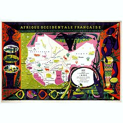
Afrique Occidentale Française AOF.
Beautiful and decorative lithograph pictorial map of Equatorial Africa, showing animals in a beautiful design… Made for Agence de la France d'Outre-Mer. The artist Alai...
- $1100 / ≈ €1029
Place & Date: Imprimerie Raidot, Paris, ca. 1950

Nouvelle carte du Roiaume D'Alger divisée en toutes ses provinces, avec une partie due cotes D'Espagne . . .
Rare and detailed map of the coast of Algeria. Large inset map of the Bay of Alger (El-Jazir). Shows a coastline of Spain around Alicante. Two compass roses in the Medite...
Place & Date: Amsterdam, 1720
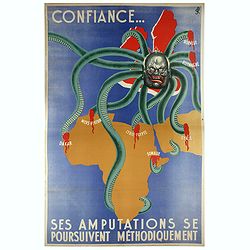
Confiance... Ses Amputations se Poursuivent Methodiquement.
Propaganda poster, produced under the NAZI collaborating Vichy French regime and designed to inspire revulsion and hatred of the English among the French, while frequentl...
Place & Date: Paris, ca. 1941

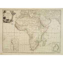
Carte d'Afrique Dressée pour l'instruction par Guillaume DeLisle. . .
The map is a rare re-issue of the Delisle map of 1722. In his first map of the continent in 1700, Delisle re-measured the Mediterranean, being the first to establish its ...
Place & Date: Paris, J.Dezauche, 1819

Insulae de Cabo Verde olim Hesperides sive .. Zoute Eylanden.
Original copper engraving, hand colored in outline, when published. Double page chart covering detailed the Cap Verde Islands in the Atlantic Ocean (Isla de San Antonia, ...
Place & Date: Amsterdam, 1655

Manoeuvres executées du 7 au 13 mai sous le Commandement du général Koeltz,par le XIXe Corps d'Armée. . .
Poster by Gaston Ry [aka René Rostagny] (1902-1978) showing the allied manouvers in Tunesia. On May 4, 1943, the nineteenth CA offensive drew most of the German tanks to...
Place & Date: Alger, Bacconnier, 1943

Carta particolare che comincia con il c.apo Aldea è Finisce con il capo Degortam. . .
Dudley’s magnificent chart shows the south west coast of Africa. A first edition without the privilege..Engraved by Lucini.Sir Robert Dudley's Dell'Arcano del Mare is t...
- $1250 / ≈ €1170
Place & Date: Florence, 1645

.Tabu nova partis Aphri.
Based on Waldseemüller's map. The maps show Northern Africa as it was known to Europeans at the first part of the 16th century. There is great details across north Afric...
Place & Date: Lyons, M. Servetus, 1535

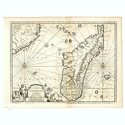
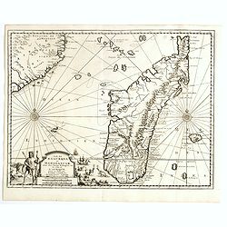
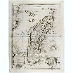
Isola di Madagascar o di S. Lorenzo Scoperta dà Portoghesi nell anno 1506. . .
Decorative and highly detailed map of Madagascar, including 2 decorative cartouches and other embellishments.The remarkable Vincenzo Coronelli (1650-1718), was a Francisc...
Place & Date: Venice, 1690

Nieuwe Pascaert van al de Carnarisse Eylanden. . .
So-called "Blue-back" sea- charts of the Canary Islands.Latitude scale, compass rose and system of rhumb lines, soundings, anchorage's, etc. A wealth of cities ...
Place & Date: Amsterdam, 1700

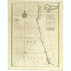
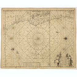
Carte particulière de la côte d'Afrique depuis le cap des Courans jusqu'à la baye de Ste Hélène. . .
Large and detailed sea chart of South Africa.Engraved by Guillaume-Nicolas Delahaye (1727-1802).Latitude and longitude scales, compass rose and system of rhumb lines, sou...
Place & Date: Paris, 1745
![[Planisphère] - Crédit Lyonnais - Fondé en 1863. Afrique du Nord à Union Française.](/uploads/cache/44865-250x250.jpg)
[Planisphère] - Crédit Lyonnais - Fondé en 1863. Afrique du Nord à Union Française.
Original pictorial lithographed advertising poster showing the western part of Africa. Published by the French bank Crédit Lyonnais.Design by Lucien_Boucher who is a fam...
Place & Date: Paris, 1950