Browse Listings in Europe > Eastern Europe
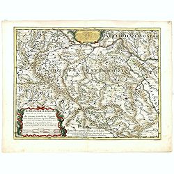
Il regno della Bossima diviso nelle sue provincie principali. . .
Rossi's map of Bosnia, based upon Sanson's map, but with revised Italian nomenclature. From a second edition of his 'Mercurio Geografico...'. The engraver was Cl. Botzot....
Place & Date: Rome, 1689

Vue et description des principales villes de l'Armenie et de la Georgie avec les habillements des femmes du pays, et ceux des prêtres et religieux armeniens. . .Tom: V N° 11 Pag: 28
View and description of the principal Armenian and Georgian cities with illustrations of Armenian women's garments as well as priests' and monks' clothing. The views are ...
Place & Date: Amsterdam, ca 1720
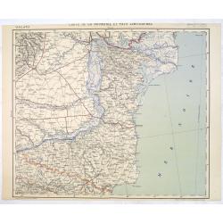
Carte de la Roumanie et Pays limitrophes. Odessa. GALATZ.
Very detailed (1:750.000) map centered on Constanta, with the river Danube in Romania. Made after an Austrian map. The French Service géographique des armées was founde...
Place & Date: Paris, 1908

Royaume de Bohéme, Marquisat de Moravie, et Silésie Autrichenne.
Small detailed map of today Czech Republic. From Atlas Portatif Universel, by Robert de Vaugondy.Unrecorded state with erased date. Page 32 outside border top right. Mary...
Place & Date: Paris, later than 1749