Browse Listings in Asia

Designs for Porcelain ware with Chinese design.
In left hand side "Planche d'aquarelle N° 05501". Original design created by the Sevres artist Gabriel Fourmaintraux ( 1886 - ) at about 1910 to serve as guide...
Place & Date: Desvres, 1905 - 1925
-250x250.jpg)
Israel.
Decorative poster advertising flights to Israel made by Georges Mathieu. The poster is one of a series of 15 composed of posters of Greece, Israel, Germany, Great Britai...
Place & Date: Paris, 1967

Ormus
A lovely map of miniature map the Kingdom of Ormus, published by Petrus Bertius, and published in Amsterdam at the beginning of the seventeenth century. With an attractiv...
Place & Date: Amsterdam, 1606

Carte du Katay ou Empire de Kin. . .
The map is of interest for the use of Mer de Corée for the sea between Korea and Japan .Fine map of Korea and China's Yellow Sea. Complete title in top: Carte du Katay o...
Place & Date: Paris, 1750

A new & accurate map of the Empire of China from the Sieur Robert's Atlas. With improvements.
An excellent early engraving of China and Korea that appeared in Sieur Robert de Vaugondy's Geographical Dictionary (London: 1759). Decorative title cartouche on the uppe...
Place & Date: London, 1759

Descriptio Arabie / Arabia.
A rare miniature map of the Arabian Peninsular. The title cartouche on the lower right corner.First published in 1598 in his Caert-Thresoor, the plates were executed by t...
Place & Date: Amsterdam, Cornelis Claes, 1606

Iava Maior.
Very fine miniature map of Java, engraved by Benjamin Wright (1575-1613). This early map contains detailed geography and nomenclature around the northern coastline of the...
Place & Date: Amsterdam, Cornelis Claes, 1606

Sumatra Insula.
A miniature map of Sumatra and the Malay Peninsula, including Singapore and the various islands directly south of it. Containing detailed geography and nomenclature aroun...
Place & Date: Amsterdam, 1609
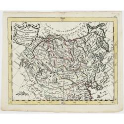
Carte Générale de l'Empire des Russes et de la Tartarie Universelle.
Rare map of Tartary and Russia, including Korea and Japan prepared after J.B.Nolin and published by Monhare for his Atlas Général a l'usage des colleges et maisons d'ed...
Place & Date: Paris, 1783
Selling price: $400
Sold in 2023

Map of China.
Showing China, Taiwan and Korea, divided into provinces with the main cities marked. The map is of interest for the use of Sea of Corea, the sea between Korea and Japan, ...
Place & Date: London, 1804