Browse Listings
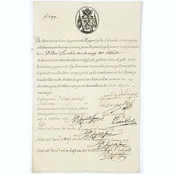
Very rare share in the Ostend Company. (299)
Upper left hand corner share number "299" in manuscript. In top emblem of the Company in copper engraving. Text: " De Directeurs van de generale Keijserlij...
Place & Date: Antwerp / Ostend, 1723
![.[Near east with Cyprus]](/uploads/cache/33857-250x250.jpg)
.[Near east with Cyprus]
Wood block printed map and one of earliest printed representation of Near east with Cyprus prepared by Martin Waldseemüller. Based on the slightly larger map from 1513 p...
Place & Date: Vienna, 1525 -1541
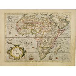
Nova Africae Tabula.
An attractive map of the continent, added by Hondius when he took over publication of Mercator's Atlas. Although it is based on Mercator's map, Hondius improved the outli...
Place & Date: Amsterdam, 1630

Xantung, sinarum imperii provincia quatra.
A map of the northern province ‘Xantung’ of China after the Jesuit Martino Martini.Shows the Great Wall and is centered on the Bohai Sea, and the Shandong and Liaonin...
Place & Date: Amsterdam, ca 1660
![[Europe, Eastern, Sarmatia, Ukraine]](/uploads/cache/33854-250x250.jpg)
[Europe, Eastern, Sarmatia, Ukraine]
Wood block printed map and one of earliest printed representation of Europe, Eastern, Sarmatia, Ukraine prepared L. Fries after Martin Waldseemüller.Based on the slightl...
Place & Date: Vienna, Trechsel, G., 1525 -1541
![Tabula electoratus Brandenburgici, Meckelenburgi, et maximae partis Pomeraniae, ex variis, famosissimisq[ue] auctoribus summo studio concinnata. . .](/uploads/cache/29543-250x250.jpg)
Tabula electoratus Brandenburgici, Meckelenburgi, et maximae partis Pomeraniae, ex variis, famosissimisq[ue] auctoribus summo studio concinnata. . .
Uncommon "carte à figures"- map engraved by the master engraver Abraham Goos and published by Claes Jansz. Visscher (1587-1652). Showing the area of Brandenbur...
Place & Date: Amsterdam, 1630
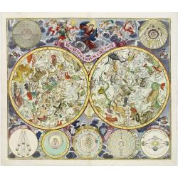
Planisphaerium Coeleste.
Magnificent double hemisphere celestial chart showing the northern and southern sky with constellations in allegorical form derived from Hevelius.A diagram in the upper l...
Place & Date: Augsburg, 1730

Veue de la Ville, et du Port de Calais, di côte de la terre.
Showing the town of Calais; landscape with, in the left foreground, group of cavalrymen led by an officer and going to right, at right two soldiers walking alongside a ca...
Place & Date: Paris, ca. 1680

Novissima et Accuratissima Totius Americae Descriptio.
Second state of Visscher's map of the Americas, this decorative map greatly influenced the cartography of the Americas both geographically and artistically.Although it di...
Place & Date: Amsterdam, 1677

Comitatus Flandria.
A highly decorative map with in the left and right top corners the pictures of archduke Albert of Austria and Isabella, queen of Spain. In the left and right borders cost...
Place & Date: Amsterdam, 1648

Magnus Ducatus Finlandiae Auct. Andrea Bureo Succo.
The first printed survey map of Finland, composed by the Swedish cartographer Anders Bureus (1571-1661). The map was published in 1662 in the second volume of Joan Blaeu'...
Place & Date: Amsterdam, 1660

China Veteribus Sinarum Regio.
Based on Jesuit surveys, the map represents the next major revision in the cartography of China after Ortelius' 1584 map. Korea, however, is still an island, and Japan co...
Place & Date: Amsterdam, 1640
![Schat-Kamer ofte konst der stuurlieden, inhoudende Een duidelyke onderwyzinge in de navigatie. . . [bound with] Geographische Tadfel vande Graaden.. Voornaamste Zee-haavens. . .](/uploads/cache/33114-250x250.jpg)
Schat-Kamer ofte konst der stuurlieden, inhoudende Een duidelyke onderwyzinge in de navigatie. . . [bound with] Geographische Tadfel vande Graaden.. Voornaamste Zee-haavens. . .
Rare and important manual originally prepared by Klaas de Vries and improved by Evert Floryn and S.Hollander of the "Schat-Kamer ofte konst der stuurlieden" (Tr...
Place & Date: Amsterdam, Wed. Gerard Hulst van Keulen, 1802

Botanibay, Englischer Verweisungs Ort fur Verbrecher. / Laijene Franzosicher Verweisungs Ort fur Verbrecher.
Copper engraving with four scenes and one portrait of Frederick III of Saxony on one sheet. In the upper part fanciful views of Botany Bay with English and French settlem...
Place & Date: Zittau, 1798-1800

Vaisseau du premier rang portant pavillon d'amiral.
Fine double-page engraved plate of a naval vessel, with the various parts of the ship numbered and identified. From Mortier's "Neptune François". From Mortier'...
Place & Date: Amsterdam, 1695

Kiepert's Physikalische Wandkarten IV. ASIEN. . .
Wall map of Asia printed in chromo lithography. Published by "Stich und Druck der lith. Anst. Von Leopold Kraatz in Berlin". Physical map showing the Asian cont...
Place & Date: Berlin, D. Reimer, 1873
![[India and China]](/uploads/cache/33875-250x250.jpg)
[India and China]
Wood block printed map and one of earliest printed representation of India and China prepared Martin Waldseemüller. Based on the slightly larger map from 1513 published ...
Place & Date: Vienna, 1525 -1541

Colossus Monarchic. Statua Danielis
Fantastic double page allegorical map of a colossus figure representing the great world empires as Daniel interpreted in Nebuchadnezzar's dream. The warrior stands stolid...
Place & Date: Augsbourg, 1730

World Flight Routes (all in Japanese).
A large very decorative Japanese world map published as sugoroku (a Japanese game which might be compared to backgammon) published as a supplement to the 1930 New Year’...
Place & Date: Osaka, 1930

Pascaerte Van't Westelyckste der Middelandsche Zee. . .
An eye-catching chart of the western part of the Mediterranean Sea.Pieter Goos (ca. 1616-1675) was one of the most important cartographer, engraver, publisher and print s...
Place & Date: Amsterdam, 1666
Very rare share in the Ostend Company.
Upper left hand corner share number 2305 in manuscript. In top emblem of the Ostend Company in copper engraving. Text: De Directeurs van de generale Keijserlijche- Indisc...
Place & Date: Antwerp / Ostend, 1723
![Ulma Folio CXCI [With view of Ulm.]](/uploads/cache/29713-250x250.jpg)
Ulma Folio CXCI [With view of Ulm.]
Double page panoramic view of Ulm.A imaginary view, however the earliest obtainable view of this period.Two page from the richest illustrated Incunabel, the famous: Nurem...
Place & Date: Nuremberg, 12 July 1493
![Boats of the Friendly Islands. [together with] A Sailing Canoe of Otaheite.](/uploads/cache/30041-250x250.jpg)
Boats of the Friendly Islands. [together with] A Sailing Canoe of Otaheite.
Early view of Queen charlotte's sound, taken from "Views in the South Seas" being a very important and early views depicting scenes encountered while employed a...
Place & Date: London, Boydell and Co., 1808
![.[India]](/uploads/cache/33861-250x250.jpg)
.[India]
Wood block printed map and one of earliest printed representation of India prepared by Martin Waldseemüller. Based on the slightly larger map from 1513 published in &quo...
Place & Date: Vienna, Trechsel, G., 1525 -1541
![The Coast of New Found Land From Salmon Cove to Cape Bonavista. . . [together with] The Coast of New Found Land from Cape-Raze to Cape St-Francis.](/uploads/cache/40658-250x250.jpg)
The Coast of New Found Land From Salmon Cove to Cape Bonavista. . . [together with] The Coast of New Found Land from Cape-Raze to Cape St-Francis.
Two charts showing the coast of New Found Land from Salmon Cove to Cape Bonavista and from Cape-Raze to Cape St-Francis. With inset chart of Trinity HarborGrierson publis...
Place & Date: Dublin, 1767
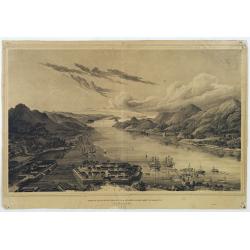
Gezigt op de haven en de baai van Nagasaki.
A very rare birds-eye view showing Deshima and Nagasaki bay. Von Siebold was born in Würtzburg, in Germany, and worked for the Dutch government as a doctor in Java. In J...
Place & Date: Leiden 1832-1852

Chungguk-do
Chungguk-do [Map of China] taken from a Korean printed Ch’onha chido [Atlas of all under Heaven] which is a 19th century version of the traditional Korean atlas produce...
Place & Date: Korea, ca. 1820

Middelbourg Ville la plus considerable de l'Isle de Walcheren et du Comté de Zelande l'une des huit provinces Unis des pais-bas . .
A very decorative and extremely rare of Middelburg, including a numbered (1-19) key in lower part. Published by Jacques Chéreau, (1688 - 1776). Engraved by Aveline and ...
Place & Date: Paris, ca.1750
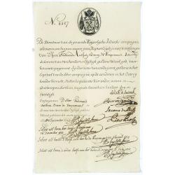
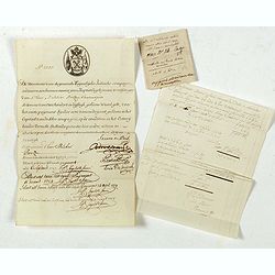
Very rare share in the Ostend Company. (4527)
Upper left hand corner share number 4527 in manuscript. In top emblem of the Ostend Company in copper engraving. Text: De Directeurs van de generale Keijserlijche- Indisc...
Place & Date: Antwerp / Ostend 1723
![Schat-Kamer ofte konst der stuurlieden, behelzende een duidelyke onderwyzinge in de navigatie. . . [bound with] Tafelen bevattende De Sinussum, tangenten en Secanten. . . [bound with] Geographische Tadfel...](/uploads/cache/33112-250x250.jpg)
Schat-Kamer ofte konst der stuurlieden, behelzende een duidelyke onderwyzinge in de navigatie. . . [bound with] Tafelen bevattende De Sinussum, tangenten en Secanten. . . [bound with] Geographische Tadfel...
Schat-Kamer ofte konst der stuurlieden, behelzende een duidelyke onderwyzinge in de navigatie. . . [bound with] Tafelen bevattende De Sinussum, tangenten en Secanten. . ....
Place & Date: Amsterdam, J. v. Keulen en Zoonen, 1777

Ignographia candiae tertia a turcis obsessae in lucem edita a F. de Wit.
A scarce broadsheet plan and view of Heraklion on one sheet: prospect 180 x 495mm, map 395 x 495mm., in the lower part a printed description "Abbildung der starken S...
Place & Date: Amsterdam, 1680
![Tabula electoratus Brandenburgici, Meckelenburgi, et maximae partis Pomeraniae, ex variis, famosissimisq[ue] auctoribus summo studio concinnata. . .](/uploads/cache/37545-250x250.jpg)
Tabula electoratus Brandenburgici, Meckelenburgi, et maximae partis Pomeraniae, ex variis, famosissimisq[ue] auctoribus summo studio concinnata. . .
Uncommon "carte à figures"- map engraved by the master engraver Abraham Goos and published by Claes Jansz. Visscher (1587-1652). Showing the part of western Po...
Place & Date: Amsterdam, 1630
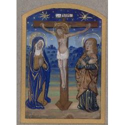
Miniature of The Crucifixion of Christ.
Page fragment from a Book of Hours with a miniature of the Cruxifiction with Saint Mary and Mary Magdalene in prayer in front of Jesus hung on the cross. This miniature c...
Place & Date: Paris, 1492 - 1494

Launa vulgo Laun Bohemiae civitas.
Bird's-eye views of Louny in Bohemia by G. Hoefnagel. The copperplate was made for Braun and Hogenberg's town book. However there the print has been transformed by the en...
Place & Date: The Hague, 1700

Asiae Minoris nova descriptio. Geographische Beschryvinge aller Landen... ende sendbrieuen der Apostele...
Extremely rare map from a Dutch bible, published by Dancker Danckerts. This map was included in a Dutch bible including several maps signed by C.Danckerts and one dated 1...
Place & Date: Amsterdam, 1643

L'Arabia delineata sulle ultime osservazioni.
First edition on laid paper. Cassini’s splendid early map of Arabia.
Place & Date: Rome, 1797

Mappa Humoristico da Europa.
A really unusual and lovely map, published in Portugal at the outbreak of The Great War in 1914. This outbreak of war in Europe was the result of a complex sequence of ev...
Place & Date: Lisbon, 1914
![.[Bangladesh, Burma, India, Thailand]](/uploads/cache/33867-250x250.jpg)
.[Bangladesh, Burma, India, Thailand]
Wood block printed map and one of earliest printed representation of Bangladesh, Burma, India, Thailand prepared Martin Waldseemüller. Based on the slightly larger map f...
Place & Date: Vienna, Trechsel, G., 1525 -1541
![Hongkong Piratenstrasse. [Pirate Street]](/uploads/cache/24363-250x250.jpg)
Hongkong Piratenstrasse. [Pirate Street]
Finely executed watercolor made by Henri Dieth of a charming street scene at "Pirate Street" in Hong Kong. The watercolor is made after Eduard Hildebrandt (1818...
Place & Date: Germany, 1882

Le comte de Namur et partie des Duchez de Brabant. . .
Decorative map centered on Namen and including the towns of Liege, Leuven, Charleroi, Dinant, Luxemburg, etc. by François Jollain (ca. 1641 – 18 April 1704).Rare "...
Place & Date: Paris, c. 1692