Browse Listings in Europe
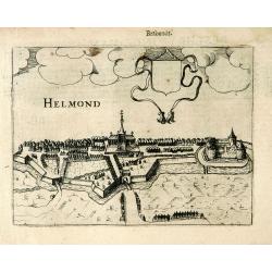
Helmond.
A panoramic view of the Helmond, seen from the Kromme Steenweg .
Place & Date: Arnhem, 1613

VI. Partie du Duche de Gueldre où se trouve la Veluwe.
Attractive small map covering the northwestern part of Gelderland. In the center "'t Loo". From Atlas Portatif Universel, by Robert de Vaugondy.Unrecorded state...
Place & Date: Paris, later than 1748

Royaume de Bohéme, Marquisat de Moravie, et Silésie Autrichenne.
Small detailed map of today Czech Republic. From Atlas Portatif Universel, by Robert de Vaugondy.Unrecorded state with erased date. Page 32 outside border top right. Mary...
Place & Date: Paris, later than 1749

ANTIBES, Ville et Port de Mer de Provence, sur la Mer Mediterranée.
Early plan of Antibes. From his "Introduction à la fortification".
Place & Date: Paris, 1693

(Postcard of Europe)
During the Great War, when the only means of communicating news to the masses was by newspapers and weekly illustrated magazines, the ‘war’ or 'military' picture post...
Place & Date: Moscow, 1914

Franciae orientalis../ Monasteriensis et osnaburgensis..
From 'Theatrum Orbis Terrarum [Atlas of the Whole World]' published in Antwerp. French text on verso.The map of Frankenland is prepared by Sebastian Rotenhan (1478-1532) ...
Place & Date: Antwerp, c.1574

Nieuwe Kaart van de Westfaalse Kreits..
Isaac Tirion was born in Utrecht ca. 1705. He came to Amsterdam ca. 1725. Tirion published a number of important books, many of which are still in demand for their intere...
Place & Date: Amsterdam, 1745

Die Zyp / La Zype.
A miniature map showing the polder of De Zype. Title cartouche in the upper side.First published in 1598 in his Caert-Thresoor, the plates were executed by the most famou...
Place & Date: Amsterdam / Frankfurt, 1609
![[ Spitzbergen ]](/uploads/cache/27541-250x250.jpg)
[ Spitzbergen ]
Two aquatints depicting the northern coasts of the Spitzbergen engraved by Fumagalli. From Giulio Ferrario's work Le Costume Ancien et Moderne ou Histoire du gouvernement...
Place & Date: Milan, 1827

't dorp Aalst.
Rare print of the old church of Aalst (near Eindhoven), from Vaderlandsche gezichten of afbeeldingen.. by J.Bulthuis, printed by H.Gartman in Amsterdam.
Place & Date: Amsterdam, 1786 / 1792

Nouvelle Carte des dix-sept Provinces des Pays-Bas.
Map of the 17 provinces of the Netherlands. In an inset upper left corner 17 coats of arms of each province and vignettes. The Channel is filled with Naval battles fought...
Place & Date: Amsterdam, ca. 1720

Ultrajectum.
An original early 17th century copper engraved miniature antique map of the Dutch province of Utrecht by Petrus Bertius, that was published in Amsterdam at the beginning ...
Place & Date: Amsterdam, 1606

Inferior Germania.
A rare miniature map of present-day The Netherlands and Belgium. Strap-work title cartouche in the lower right corner with scale. Expertly engraved by Petrus Kaerius, the...
Place & Date: Amsterdam, 1606

s'Lands en Oost-Indische Lynbanen. & t'Oost-Indisch-Huys.
A decorative print of the Lynbanen a place were V.O.C. ship riggings and ropes were produced and kept.
Place & Date: Amsterdam, 1760-1767

Le Chantier d'Amsterdam.
Decorative lithography representing the head quarters of the V.O.C. and shipyard in Amsterdam. The building serves nowadays as the Maritime Museum. After a painting by A....
Place & Date: Brussels, J. B. A. Jobard, 1825
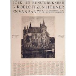
Kasteel Heeswijk.
Very fine etching of the Castle of Heeswijk, by the well-known etcher Ludwig Willem Reymert Wenckebach. He was born in The Hague on 12 January 1860 and died in 1937. The ...
Place & Date: Amsterdam, 1901

Languedoc - Foix Roussillon.
Very decorative, informative map of Languedoc - Foix Roussillon region in south eastern France. Including the towns of Carcassonne, Montpellier, Albi, Toulouse, etc.The m...
Place & Date: France, 1943

Guyenne - Gascogne.
Very decorative, informative map of Guyenne and Gascogne region in France. The map is filled with buildings, animals, figures and two locals. With a large compass rose in...
Place & Date: France, 1943

Prospectus veteris castelli Graviae.
One of the earliest views of the ancient Castle of Grave. Engraved by Casper Bouttats. With a description in Latin, French and Dutch.
Place & Date: Amsterdam, 1695
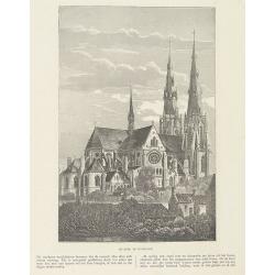
Sint Catharinakerk te Eindhoven.
Uncommon woodblock engraving of St.Catharina church of Eindhoven, built by the well-known architect P.Cuijpers. Published in Katholieke Illustratie.The "katholieke i...
Place & Date: 'sHertogenbosch, Henri Bogaerts, 1875

Biturigum.
A miniature map of the Berry. Fine cartouche in the upper left corner.First published in 1598 in his Caert-Thresoor, the plates were executed by the most famous engravers...
Place & Date: Amsterdam/Frankfurt 1609
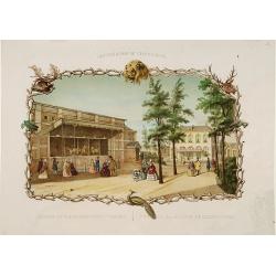
Rotterdamse Diergaarde. . .
Decorative view of Zoo of Rotterdam. To the right the house of the manager of the zoo. Decorated with personages in typical dress watching lions.
Place & Date: Amsterdam, 1860

Het Huisje door Czaar Peter den Grooten in den Jare 1697 te Zaandam bewoond.
Engraved by Cornelis van Baarsel (Utrecht 1761 - Amsterdam 1826-08-17) after a design of T. Monsieur M.Z. who made his drawing "after nature".A first state, the...
Place & Date: Zaandam, 1823
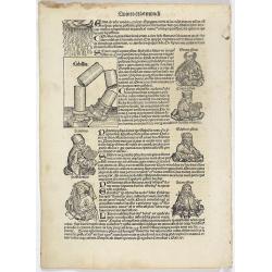
Quinta Etas Mundi. Folium. LXXXII
Latin text page with woodcuts on recto and verso of Saints, Kings, and Queens. On verso a large wood cut of A giant colossus, executed by Chares of Lindus (Clare Lydo), t...
Place & Date: Nuremberg, 12 July 1493

The hanging of the head of police Jean Grauwels in Brussels, 11 february 1569.
Print relating to Brussels during the first decades of the eighty year war between Spain and the Low Countries: (plate 18). This plate shows the hanging of the head of po...
Place & Date: Cologne, ca. 1590

s'Lands en Oost-Indische Lynbanen.
A decorative print of the Lynbanen a place were V.O.C. ship riggings and ropes were produced and kept.
Place & Date: Amsterdam, 1760-1767

t'Oost-Indisch-Huys.
A decorative print of the East Indian House, the headquarters of the V.O.C., a place for meeting, trading and storage of spices and ship equipment. The maps and charts we...
Place & Date: Amsterdam, 1760-1767

Arcenal de l'Amirauté.
A decorative print of the 'T Landts Magazyn , or 'Scheepvaart Museum' (Naval Museum).
Place & Date: Amsterdam, ca. 1700

Prospectus Castelli Boxtel.
One of the earliest views of the Castle of Boxtel. Engraved by Henricus Cause. With a description in Latin, French and Dutch.
Place & Date: Amsterdam, 1695

Kasteel Croij.
Decorative lithography of the castle of Croij.
Place & Date: Den Haag, 1880

Dynastiae Comitat. Schoenburgici Penig, Remissa, Rochsburg, Wechselburg In Clientela Elect: Saxon Glaucha, Hartenstein, Lichtenststein, Walkenburg. . .
A very uncommon and superbly decorative map of Lower Saxony, the region southwest of Dresden. Including the towns of Rochlitz, Geringswalde, Mittweida, Frankenberg, Chemn...
Place & Date: Augsburg, 1750

Russie Européenne . . .
Detailed map of European part of Russia, including Finland and Lapland.Gilles Robert de Vaugondy (1688–1766), also known as Le Sieur or Monsieur Robert, and his son, Di...
Place & Date: Paris, ca. 1753

La Saxe Contenant le Routes et les postes. . .
Fine post-route map of Saxony in Germany with a splendidly engraved title cartouche. The map is centered on Leipzig. George Louis Le Rouge was active between 1740 and 178...
Place & Date: Paris, 1756

U.R.S.S. Energie Eléctrique. (5)
Map of Russia. Publicity poster for Russia's electrical production. Text in French. Editions de l'Agence de presse Novosti".More about War Maps & Propaganda maps...
Place & Date: USSR, 1978

Vue de la ville et du château de Heidelberg . . . Ansicht der stadt und des schlosses Heidelberger . . .
Engraving after Louis Charles François de Graimberg-Belleau. Engraved by Ch. Haldennvang.French artist. Son of Gilles-François Belleau Graimberg. Louis Charles Françoi...
Place & Date: Graimberg, Heidelberg, ca. 1840
![Lutece conquise par les François sur les Romains ou second plan de la ville de Paris [...] par M.L.C.D.L.M.](/uploads/cache/42141-250x250.jpg)
Lutece conquise par les François sur les Romains ou second plan de la ville de Paris [...] par M.L.C.D.L.M.
Engraved plan of Paris, published in "Traité de la police de Nicolas de Lamare". Oriented to the North with a compass rose and equipped with a double scale (40...
Place & Date: Paris, 1729

III. Carte de la Hollande.. Over-Yssel.
Attractive small map centered on the delta of the River Ijssel, where it discharges into the Zuiderzee.From Atlas Portatif Universel, by Robert de Vaugondy. Unrecorded st...
Place & Date: Paris, later than 1748

Langwasser Stanislau Neu Brandenburg Mei 1942 Juni 1945
Map met reproducties van crayontekeningen van Krijgsgevangenschap in Langwasser, Stanislau en Neu-Brandenburg, Mei 1942 -juni 1945.Uitgegeven april 1948 door het Minister...
Place & Date: Den Haag, April 1948
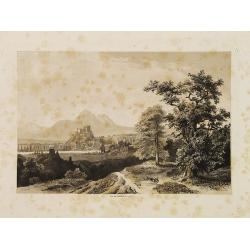
Salzbourg.
Uncommon and decorative lithography published by Carl Johan Billmark and printed by Lemercier in Paris, 55 rue de Seine, the leading firm in Europe at that time. From: It...
Place & Date: Paris, c.1859

Carte particuliere d'une grande partie des estats situez sur le haut rhein et sur les rivieres qui si déchargent comme sont L'Alsace, la Souabe et la Lorraine,&c. . .
Detailed map of Alsace, Lorraine and Souabe, centered on the River Rhine.
Place & Date: Paris, 1705