Browse Listings in Europe
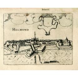
Helmond.
A panoramic view of the Helmond, seen from the Kromme Steenweg .
Place & Date: Arnhem, 1613

Nieuw Nederlandtsch Caertboeck. Waer in volkomentlijcker als oyt te voren vertoont werden de XVII. Nederlanden.
Rare first edition of this atlas of the provinces of the Netherlands, Belgium and Luxemburg. Engraved title page, with : "Gedruckt t' Amsterdam by Abraham Goos Plaet...
Place & Date: Amsterdam, 1616

Deliciae Batavicae.
It is a charming book illustrated with portraits of Willem of Orange and Prince Maurits and eight engraved armorial plates. Followed by 30 engraved views or scenes of ...
Place & Date: Amsterdam, Johannes Janssonius, 1618

Frisia occidentalis.
A rare separately published carte-a-figures of Friesland by Geelkercken in its first state. The title and the coats of arms of the eleven Frisian towns appear in the cent...
Place & Date: [Leeuwarden], Dierick Albertsen, 1618

Premislia celebris russiae civitas.
RARE only included in part VI of his town book. Bird's-eye of Przemysl in Poland. Frans Hogenberg (1535 Mechelen - Cologne 1590) was a copper engraver and etcher. Georg B...
Place & Date: Cologne, 1618
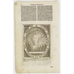
Maria De Medices D. G Galliae et Navarrae Reg. Uxor Henr. IIII.
The engraving depicts a half length oval portrait of Marie de' Medici, queen consort of France .Nicolaes de Clerck (de Klerc) was active as engraver and publisher in Delf...
Place & Date: Amsterdam, Cloppenburch, 1621

Angliae, Scotiae, et Hiberniae, sive Britannicar : Insularum descriptio.
A rare and ornate map with inset portraits of James First, Henry Prince of Wales Princess Anne of Denmark.Janssonius acquired the copperplate of van den Keere's 1604 Brit...
Place & Date: Amsterdam, 1621

Typus Frisiae Orientalis à Dullarto
One of the most decorative maps of East Frisia and its important shipping center of Emden and the Watten Islands, from the cartography of Ubbo Emmius, a local cartographe...
Place & Date: Amsterdam, ca. 1624

Marchionatus Sacri Romani Imperii.
A wonderfully decorative map showing in the middle of the image a town plan from Antwerp and in the lower part an inset with a panoramic view of the city and harbour of A...
Place & Date: Amsterdam, 1617- 1624

Carte de la Coste de La Rochelle a Brouaige et de l'Isle d'Oleron Observee par le S.r de Chattillon ingenieur du Roy.
Map of the island of Oléron, with an inset in lower left corner showing the route of an English fleet to La Rochelle. At the time of mapping the area was a stronghold of...
Place & Date: Paris, 1627