Browse Listings

Carte de L\'Egypte de la Nubie de L\'Abissinie. . .
Prepared by G.de l'Isle. Uncommon issue by Hendrik de Leth. Very detailed map of northeastern Africa, the Red Sea and the Arabian peninsula shows the political divisions ...
Place & Date: Amsterdam, 1740
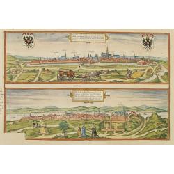
Vienna.. / Buda..
Pair of views on one sheet, the first showing the Austria capital of Vienna with fields, and figures in the foreground.Lower view shows the Hungarian capital of Budapest....
Place & Date: Cologne 1580
![Anverpia, nobile in Barbantia oppidum, parrim maritimum . . . [Antwerp]](/uploads/cache/26518-250x250.jpg)
Anverpia, nobile in Barbantia oppidum, parrim maritimum . . . [Antwerp]
The bird's-eye plan provides an excellent view of the citadel, city, docks and fortifications. The city was defended by a line of fortification and a moat constructed und...
Place & Date: Cologne, 1585

Nova et Accurata totius EUROPAE Descriptio Authore Frederico de Wit Amstelodami.
General map of Europe richly ornamented with small compass rose and Europa shown riding Zeus in the form of a bull, and several putti holding the title banner aloft.
Place & Date: Amsterdam, 1680

Alssleben.
The engraver and publisher of prints, Mrs. Anna Beek of the Hague, enlarged the print and mounted it on larger paper: she colored it in pastel colors, adding extensive cl...
Place & Date: The Hague, ca. 1700

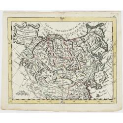
La Tartaria Chinese.
With decorative title cartouche. Covering north eastern part of China, with good detail in Korea and a curious shape for Hokkaido (here called Jeso-Gasima ).Engraved by G...
Place & Date: Venice, 1784

Carte Geo-Hydrographique du Golfe du Mexique et de ses Isles..
Map of the Caribbean and Gulf of Mexico showing the various islands and continental coastlines according to the 18th century Venetian cartography of Rizzi Zannoni.Illustr...
Place & Date: Paris, ca 1783

Mappa Aestivarum Insularum alias Barmudas.
Blaeu based his work on John Speed's remarkably accurate map of 1626-1627. It shows the island divided into tribes and lots, and below the map itself appear the names of ...
Place & Date: Amsterdam, 1635
Carte Générale de l'Empire des Russes et de la Tartarie Universelle.
Rare map of Tartary and Russia, including Korea and Japan prepared after J.B.Nolin and published by Monhare for his Atlas Général a l'usage des colleges et maisons d'ed...
Place & Date: Paris, 1783
Selling price: $400
Sold in 2023

Erfolgte Kapitulation zwischen dem General Bonaparte und den Gross Leister von Malta. Vor der Hauptstadt Walette zu Maltha, am 10 Juni 1798.
Copper engraving with three scenes and one portrait on one sheet. In upper a view of Bonaparte arriving at Valletta. Published in "Allgemeine Welt-Chronik oder neue ...
Place & Date: Zittau, 1798-1800

Etats du Grand-Seigneur en Asie, empire de Perse, pays des Usbecs, Arabie et Egypte.
Detailed map of the region bounded by the Black Sea, Georgia, the Caspian, Uzbekistan, The Indian Ocean, Saudi Arabia (here called \"Arabie Heureuse\"), Egypt a...
Place & Date: Venise, 1778

Arabie.
Uncommon miniature map of the Arabian peninsula, from Pierre Duval's La Geographie Universeille dated 1676. Following his Cartes de géographie in 1657, Pierre Duval publ...
Place & Date: Paris, 1676
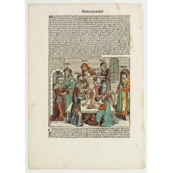
Sexta Etas Mudi. / Simon Beatus .. / Folio CCLIIII.
A very fine presentation of the circumcision of Simon (192 x 223 mm.). RECTO: a falling star, a portrait of a King and an officer wearing armour. Page from the richest il...
Place & Date: Nuremberg, 12 July 1493
![[Title page] Perspective die hooch-gheroemde conste..](/uploads/cache/25554-250x250.jpg)
[Title page] Perspective die hooch-gheroemde conste..
Title page from Perspective, Dat is, de hooch-gheroemde conste eens schijnende in oft door-siende ooghen-ghesichtespunt ... (&c.) by Hans, or Johannes Vredeman de Vri...
Place & Date: Leiden, 1604
![Sexta Etas Mundi. Ratisbonna. [Ratisbonne]](/uploads/cache/13549-250x250.jpg)
Sexta Etas Mundi. Ratisbonna. [Ratisbonne]
A very fine presentation of the city of Ratisbon, in Germany, centered on the cathedral (Dim. : 191 mm W : 525 mm).Overleaf a very nice view of Vienna, with two swans on ...
Place & Date: Nuremberg, 12 July 1493
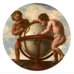
Allegory of geography.
Two putty studying a terrestrial globe, one of them holding a pair of dividers. The information on the globe is clearly imaginary but the two cartouches and ships are typ...
Place & Date: Bruges, ca. 1700

A unique composite atlas with updated Porro maps.
Unique composite atlas containing in total 84 maps - 82 maps engraved by Girolamo Porro and heavenly reworked around 1686 and 2 newly engraved maps; Piccola Tartaria (Cr...
Place & Date: Venice, 1686

Carte du Gouvernement de Provence, suivant les nouvelles observations...
Fine copper engraved and decorative map of the Provence region in the south of France. It includes the cities of Nimes, Viviers, Avignon, Aix and Nice. The pictorial cart...
Place & Date: Amsterdam 1728
![Kantong [The Dutch Folly Fort off Canton]](/uploads/cache/05714-250x250.jpg)
Kantong [The Dutch Folly Fort off Canton]
Charming 18th water color on paper depicting The Dutch "Folly Fort" off Canton. Probably made by a western artist visiting China.Forts were built in several pla...
Place & Date: Canton?, c.1750

(EUROPE).
The map of Europe has been identified as the work of Hieronimus Münzer (1437-1508), a Nuremberg physician who supplied the geographical contents of the chronicle. The Eu...
Place & Date: Nuremberg, 1493

The Rubaiyat of Omar Khayyam (Edward Fitzgerald translation)
Edward FitzGerald, an outstanding writer who has done more than anyone to popularise English poetry. His best-known work, The Rubaiyat of Omar Khayyam (1859), began by be...
Place & Date: England, ca. 1930

Corea and Japan.
A fine large-scale map of Japan and Korea showing an increasingly refined outline to the Japanese islands but still oversized Korean peninsula. The strait south of Korea,...
Place & Date: Edinburgh, 1816

Biturigum.
A miniature map of the Berry. Fine cartouche in the upper left corner.First published in 1598 in his Caert-Thresoor, the plates were executed by the most famous engravers...
Place & Date: Amsterdam/Frankfurt 1609

Carte de la Turquie, de l'Arabie et de la Perse..
Large map of the Near East, based upon earlier maps by De L'Isle. Shows also most part of the Mediterranean basin as well as north-eastern Africa. Relief shown pictoriall...
Place & Date: Amsterdam c. 1745

Carte du Katay, ou Empire de Kin : pour servir a l'Histoire de Jenghiz Khan, raportée dans l'Histoire generale des voyages, tirée de l'Angloise.
The map is of interest for the use of East Sea, the sea between Korea and Japan, here called "Mer de Corée".Fine map of Korea and China's Yellow Sea. Complete ...
Place & Date: Paris, 1750
Selling price: $450
Sold in 2023

Constantinopolis.
A spectacular woodcut panorama of the ancient city of Constantinople, proporting to show the pre-Turk city (for example naming St Sophia). (235x522mm).One of the earliest...
Place & Date: Nuremberg, 12 July 1493

A ship's hour glass
The element common to celestial position-finding, the calculation of speed for dead reckoning and even everyday life at sea is the time: hence ways of determining and kee...
Place & Date: ca. 1790
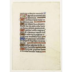
Leaf on vellum from a manuscript Book of Hours.
RECTO: One 2-lines initial decorated with flower in liquid gold on colored grounds and seven 1-line initials in liquid gold on colored grounds and six line-fillers in sam...
Place & Date: France, ca.1530

Nouvelle Mappa Monde.
State 2 of this fine double hemisphere world map, from an unusual perspective, with a "Mer de L'Ouest" or "Sea of the West". Paris is located at the c...
Place & Date: Venice, 1776 - 1784
![Posesiones de America : Isla de Cuba. [together with] Isla de Cuba. . .](/uploads/cache/23458-250x250.jpg)
Posesiones de America : Isla de Cuba. [together with] Isla de Cuba. . .
Wall size sea chart and map of land areas showing all of Cuba, part of Florida Keys plus San Adios and Salvador Grande in the Bahamas.Minute topographical, political, and...
Place & Date: Madrid, 1853 / 1851
![[The creation of the world - First day]](/uploads/cache/24509-250x250.jpg)
[The creation of the world - First day]
Attractive page from the Nuremberg Chronicle, showing the creation of the world: the First Day, showing the celestial choir (God\'s creation of the angels) surrounding th...
Place & Date: Nuremberg, 12 July 1493

Les jeunes voyageurs en Europe, ou description raisonnée des divers pays compris dans cette partie du monde.
The second edition of this fine travel companion is illustrated with 16 very decorative maps, each map surrounded by local products and specialties of the region. Include...
Place & Date: Paris, Thiériot, 1827