Browse Listings

Danubius Fluvius Europae Maximus, a Fontibus ad Ostia..
Depicts the course of the Danube River, from its sources in the Alps to the Black Sea..Because of the dimensions the map was printed from two copper plates.With two very ...
Place & Date: Amsterdam, 1638

Dominio Veneto nell' Italia.
With the Gulf of Venice. Including the towns of Cremona, Brescia, Venice, etc.As Willem Blaeu died in 1638 most of his maps are actually published by his son Joan. This m...
Place & Date: Amsterdam, 1638

Manuscript atlas.
Charming manuscript atlas with 6 maps, pen and ink and water color, showing France, Europe, Africa, Palestine, North America and South America.The atlas is done by a youn...
Place & Date: France, 1835

Recueil de divers voyages faits en Afrique et en l'Amerique, qui n'ont point esté encore publiez.
First edition of this collection of significant and interesting voyages, edited by a scholar and book collector who served in the employ of Louis XIV before being appoint...
Place & Date: Paris, Louis Billaine, 1674

Atlas géographique des quatre parties du monde.
Interesting atlas printed during the French Revolution (1789-1799) by Ph. Dezauche. The title cartouche of the newly made map (6bis) "Carte de France, suivant sa nou...
Place & Date: Paris, Dezauche, De L'Isle et Buache, 1789-1799

Languedoc - Foix Roussillon.
Very decorative, informative map of Languedoc - Foix Roussillon region in south eastern France. Including the towns of Carcassonne, Montpellier, Albi, Toulouse, etc.The m...
Place & Date: France, 1943

Guyenne - Gascogne.
Very decorative, informative map of Guyenne and Gascogne region in France. The map is filled with buildings, animals, figures and two locals. With a large compass rose in...
Place & Date: France, 1943
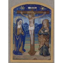
Miniature of The Crucifixion of Christ.
Page fragment from a Book of Hours with a miniature of the Cruxifiction with Saint Mary and Mary Magdalene in prayer in front of Jesus hung on the cross. This miniature c...
Place & Date: Paris, 1492 - 1494
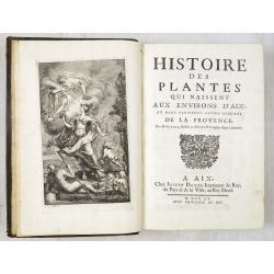
Histoire des Plantes qui naissent aux environs d'Aix et dans plusieurs autres endroits de la Provence.
One of the most attractive early French local floras, with delightful engraved plates. The work describes the flora of the Provence, especially the plants growing near Ai...
Place & Date: Aix, J. David, 1715
Carta militar das principaes estradas de Portugal.
Rare road map of Portugal in a scale of ca 1:470000. At the bottom right and left legends in Portuguese and French. Engraved by Romão Eloy de Almeida, who was a Portugue...
Place & Date: Lisbone, 1808

Launa vulgo Laun Bohemiae civitas.
Bird's-eye views of Louny in Bohemia by G. Hoefnagel. The copperplate was made for Braun and Hogenberg's town book. However there the print has been transformed by the en...
Place & Date: The Hague, 1700
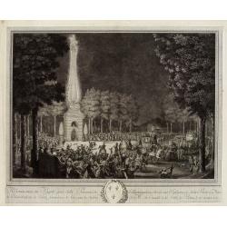
Réjouissances du Peuple près de la Pyramide d'Illumination, élévée sur l'Esplanade de la Porte de Mars et Distribution de Vivres, fontaines de Vin , sous les Ordres de Mrs. Du Conseil de la Ville, à Reims le 27 Aoust 1765.
Engraved by Varin after Moreau Jr. The print shows a lightning spectacle held in Reims on 27 August 1765.
Place & Date: Paris, 1771

Langwasser Stanislau Neu Brandenburg Mei 1942 Juni 1945
Map met reproducties van crayontekeningen van Krijgsgevangenschap in Langwasser, Stanislau en Neu-Brandenburg, Mei 1942 -juni 1945.Uitgegeven april 1948 door het Minister...
Place & Date: Den Haag, April 1948

Extract uit de Resolutien door Heeren Bewindhebberen der Oost-Indische Compagnie gecommitteerd ter Vergadering van 17e binnen Amsterdam genomen op Donderdag
Contains a list of resolutions dated from 27th November 1783 and reports about the dumping of oil, tar etc. into the sea.
Place & Date: Amsterdam, 1751
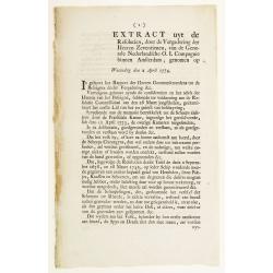
Extract uyt de Resolutien, door de Vergadering der Heeren Zeventienen, van de Generale Nederlandsche O. I. Compagnie binnen Amsterdam, genomen op Woensdag den 2 April 1774.
Contains a list of resolutions dated from 2nd April 1774 and concerning health care. Boarding crew had to be examined by the ship's surgeon. People with illnesses were to...
Place & Date: Amsterdam, 1751
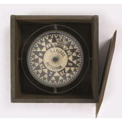
Compass.
A very nicely crafted sloop compass in original box. The compass is gimbaled and is executed in beautiful red copper. Made and signed by F.J. Kloos & Son of Rotterdam...
Place & Date: Rotterdam, 1850-1875
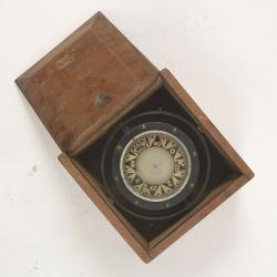
Compass.
A sloop compass in the original wooden box with lit. The compass with floating rose (Cardan system). Slung in gimbals, the east point is decorated and graduated in half ...
Place & Date: c. 1890-1900
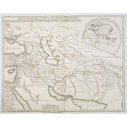
Partie Orientale de la Carte des Anciennes Monarchies. . .
This map depicts the eastern part of the Ancient World, Partie Occidentale de la Carte des Anciennes Monarchies including the Near East, Cyprus, Black Sea, Caspian Sea, I...
Place & Date: Paris, ca. 1800

Typus Galliae Veteris, Ex conatib' Geograph. Abrah.Ortelii.
A very decorative map with countries of ancient France prepared by Abraham Ortelius and published by one of the most famous map publishers, Willem Blaeu.
Place & Date: Amsterdam, 1645

Amsterdam Ville du comté de Hollande. . .
A very decorative and very rare town-view of Amsterdam, including a numbered key ( A- T) in the lower part. Engraved by Pierre-Alexandre Aveline. With the signature "...
Place & Date: Paris, ca.1692
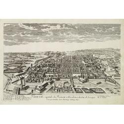
Turin ville capitale du Piémont, et Résidence du Duc de Savoye. . .
A very decorative and rareof Turin, including a numbered key (A-M) in lower part. Engraved by Pierre-Alexandre Aveline. With "fait par Aveline avec privilege du Roy ...
Place & Date: Paris, ca.1692

Mastric ou Maëstricht, Ville du Brabant-Hollandois. . .
A very decorative and extremely rareof Maastricht, including a numbered key (1-23) in lower part. Engraved by Pierre-Alexandre Aveline. With "Fait par Aveline avec p...
Place & Date: Paris, ca.1692

Océanie.
A very decorative 19th century map of the Pacific Ocean, with hand colored lines indicating the extent of Polynesia, Micronesia, Melanesia, and Malaysia (or Southeast Asi...
Place & Date: Paris, 1850

Entrée des forêts de la rivière Sedger. . .
Exquisite contemporary colored lithograph of Sedger's river in the Chili, with as seen by Dumont D'Urville's, with Indians. Drawn by Louis Le Breton, lithographed by Bich...
Place & Date: Paris, 1846
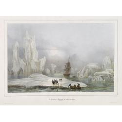
La Corvette la recherche au milieu des glaces.
Beautiful lithograph by A. Mayer and Bayot of the corvette "La recherche" surrounded by Ice. Published by Arthus-Bertrand and Lemercier in Paris.From Joseph Pau...
Place & Date: Paris. Arthus-Bertrand, 1838-1852

L'escadre alliée bombarde les forts extérieurs de Sébastopol. (18 octobre 1854)
Beautiful Crimean War lithography by Becquet after a painting by Louis Le Breton. The print illustrates the ships "Fort Constantin", "la ville de Paris&quo...
Place & Date: Paris, 1860
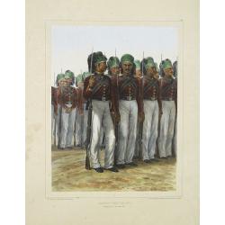
Infanterie Turque (chasseurs). 7 novembre 1837.
Beautiful lithography by Auguste Raffet (1804 -1860 ) and printed by Auguste Bry.
Place & Date: Paris, Gihaut frères, 1848

Rivage du port Saint-Nicolas.
Exquisite contemporary colored lithograph of Port Saint-Nicolmas Bay in most southern part of South America, with Dumont D'Urville's officers making landfall. Drawn by E....
Place & Date: Paris, 1846

Insulae de Cabo Verde olim Hesperides sive .. Zoute Eylanden.
Original copper engraving, hand colored in outline, when published. Double page chart covering detailed the Cap Verde Islands in the Atlantic Ocean (Isla de San Antonia, ...
Place & Date: Amsterdam, 1655

Group of 21 watercolors of scenes in Iceland, included are vulcanos like Eyjafjallajokull, Öræfajökull, etc.
A group of water colors made during visits of the artist F. de Boungne to Iceland, among them are contemporary artistic impressions of the now world-famous volcano Eyjafj...
Place & Date: Iceland, 1933-1944

Belgica Foederata. . .
Decorated with a cartouche showing the coats of arms of Zeeland, Holland, Utrecht, Friesland, Groningen and Overijssel. T.C. Lotter married M. Seutter's daughter in 1740 ...
Place & Date: Augsburg, ca.1760

Il Governo di Guascogna con porzione del Governo di Guienna.
Rare regional map of France of the Périgord, Guienne, Gascogne and the Béarn published by Carli Pazzini in Siena.
Place & Date: Siena, 1792
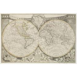
Mappemonde ou globe terestre dressée sur les Nouvelles Observations . . .
Scarce world map with all the major early explorers. Jean Baptiste Louis Clouet (born 1730) was a member of the Academie Royale des Sciences de Rouen and the author of Ge...
Place & Date: Paris, Mondhare, 1787

Carte des Isles de Maiorque Minorque et Yvice dediée A.M. le Comte de Maurepas Ministre et secretaire d'Etat. . .
Fine map of the Baleares with much detail, in lower part inset "Plan du Port de Mahon du Fort St. Philippe et ses Fortifications". The map is dedicated to Jean ...
Place & Date: Amsterdam, after 1740

Gouvernement general de Champagne. . .
Fine map of Champagne with a decorative title and scale cartouche.Alexis-Hubert Jaillot (1632-1712), was a French cartographer. He joined the Sanson heirs and redrew Nico...
Place & Date: Amsterdam, 1692
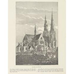
Sint Catharinakerk te Eindhoven.
Uncommon woodblock engraving of St.Catharina church of Eindhoven, built by the well-known architect P.Cuijpers. Published in Katholieke Illustratie.The "katholieke i...
Place & Date: 'sHertogenbosch, Henri Bogaerts, 1875

Henna ardera deel. De vijfde Grietenije van de Wester goo. . .
Very detailed map of "Henna ardera deel. De vijfde Grietenije van de Wester goo" in Friesland prepared by Bernardus Schotanus Steringa. With decorative title ca...
Place & Date: Leeuwarden, 1718

Kollumer land En het Nieuw Kruys land de vijfde gritenije van Oostergoo . . .
Very detailed map of "Kollumer land En het Nieuw Kruys land de vijfde gritenije van Oostergoo" in Friesland prepared by Bernardus Schotanus Steringa. Centered o...
Place & Date: Leeuwarden, F. Halma, 1718

Carte de la Manche. . .
Decorative chart showing the Chanel, with the coastline of France from La Baie de Douarnenez to Dunkerque, and the coastline of England from Stroble head to Manning Tree....
Place & Date: Amsterdam, 1692

Le comte d'Artois dresse sur les memoires les plus nouveaux. . .
Map showing the north of France, showing St Omer, and Arras, etc. The map notes Nicolas Sanson as the mapmaker and claims that the map was published by Alexis-Hubert Jail...
Place & Date: Amsterdam, 1693