Browse Listings in Australia & Oceania
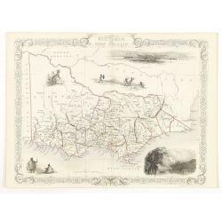
Victoria or Port Phillip.
Decorative steel engraved map of Victoria or Port Phillip, surrounded by illustrations of Melbourne, indigenous people and the Glenelg River. Interlocking border design. ...
Place & Date: London, ca. 1851
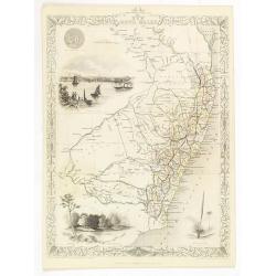
New South Wales.
Decorative steel engraved map of New South Wales, surrounded by illustrations of Sydney Cove, native trees and the seal of New South Wales. Interlocking border design. Ta...
Place & Date: London, ca. 1851
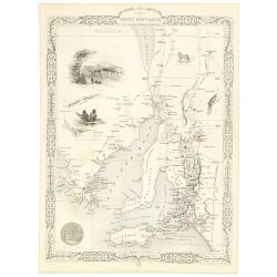
Part of South Australia.
Decorative steel engraved map of part of South Australia, surrounded by illustrations of Adelaide, natives on a catamaran, an Australian dog and a nymphicus bird illustra...
Place & Date: London, ca. 1851

Océanie.
A very decorative 19th century map of the Pacific Ocean, with hand colored lines indicating the extent of Polynesia, Micronesia, Melanesia, and Malaysia (or Southeast Asi...
Place & Date: Paris, 1850

Océanie.
A very decorative 19th century map of the Pacific Ocean, with hand colored lines indicating the extent of Polynesia, Mirconesia, Melanesia, and Malaysia (or Southeast Asi...
Place & Date: Paris, 1850

Mar del Zur, Hispanis Mare Pacificum.
Janssonius' fine chart of the Pacific including the west coast of America with California shown as an island, Japan and a small Australian coastline. This is the earliest...
Place & Date: Amsterdam, 1650
![[ Traditional tools from New Caledonia ].](/uploads/cache/26366-250x250.jpg)
[ Traditional tools from New Caledonia ].
Aquatint depicting a variety of traditional tools from New Caledonia engraved by Rossi. Plate N° 72. From Giulio Ferrario's work Le Costume Ancien et Moderne ou Histoi...
Place & Date: Milan, 1827
![Vue de la Rivière d'Endeavour sur la Côte de la Nouvelle Hollande ou le Vaisseau fut mis à la bande. [Tome IV Pl. 1ère.]](/uploads/cache/26093-250x250.jpg)
Vue de la Rivière d'Endeavour sur la Côte de la Nouvelle Hollande ou le Vaisseau fut mis à la bande. [Tome IV Pl. 1ère.]
The first known landscape drawing of the east coast of Australia. A View of the Endeavour River, on the coast of New Holland, where the ship was laid on shore, in order t...
Place & Date: Paris, 1773