Browse Listings in America

Tabula Americae Specialis Geographica Regni Peru, Brasiliae, Terra Firmae & Reg: Amazonum, Secundum relationes de Herrera, de Laet & PP d Acuña & M. Rodriguez . . .
A good and clean copy of Homann's map of the northern part of South America. The map is on the Valley of the Amazon and delineates the Amazon and its labyrinth of tributa...
Place & Date: Nuremberg, 1728

Yucatan . . . Et Guatimala Conventus Iuridicus.
Very attractive map encompassing the Mexican heartland, the Yucatan peninsula, and the old Spanish Audiencia of Guatemala including Honduras, Nicaragua, Costa Rica and pa...
Place & Date: Amsterdam, 1673

Les Isles Terceres. . .
Uncommon map of the Azores. Engraved by Sommer. Du Val is mentioned as the cartographer and the publisher was Pierre Mariette.
Place & Date: Paris, c. 1650 - 1676

Carte des Isles d'Acores.
Uncommon and detailed map of the Azores. With inset maps of Port de St.Cruz and harbor and town of Angra on the island of Terceira. It was at the time an important port a...
Place & Date: Amsterdam, 1730
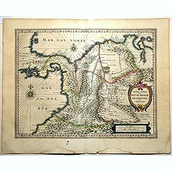
Terra Firma et Novum Regnum Granatense et Popayan.
A handsome map of modern-day Panama and Colombia. The cartouches and decoration are colored in an artistic way. Very fine and rare with this type of coloring.From "l...
Place & Date: Amsterdam, 1635-1638

Carte Geo-Hydrographique du Golfe du Mexique et de ses Isles..
Map of the Caribbean and Gulf of Mexico showing the various islands and continental coastlines according to the 18th century Venetian cartography of Rizzi Zannoni.Illustr...
Place & Date: Paris, ca 1783

Plan der Stadt Quebec Haupstadt in Neu Franckreich oder Canada.
Town-plan of Quebec, with an inset view of the town in the lower right corner. In the upper right a recapitulation of the main military actions prior to the surrender of ...
Place & Date: Nurnberg, 1770

Brasila.
Map of Brazil extending from C. Nasou and Parime Lago to the Mouth of the Rio de la Plata. Oriented with West on top.The cartography of the region is quite primitive. The...
Place & Date: Amsterdam, 1673

Carte qui contient..Iles & Terres..L'Amerique..Jamaique..
Eight maps on one sheet. From Chatelain's Atlas Historique et Méthodique . Including maps of Bermuda, Jamaica, New England with Long Island, Carolina, Chesapeake and Del...
Place & Date: Amsterdam 1728
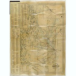
Plano de los Ferro-Carriles de Republica Argentina 1902.
Folding rail road map of Argentina, with inset of Buenos Aires in upper right corner.
Place & Date: Buenos Aires, ca. 1902