Browse Listings in World Maps

Nova Totius Terrarum Orbis Geographica ac Hydrographica Tabula.
A beautifully decorative world map taken from the 'English Atlas' by Moses Pitt and Steven Swart, based on an earlier engraved world map by Pieter van den Keere ca. 1630,...
Place & Date: Oxford, 1680
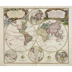
Planiglobii Terrestris - Mappe-Monde...
Word map in double hemisphere. In center two smaller hemispheres of the north and south pole are shown. Two interesting diagrams depict the earth as it would be seen from...
Place & Date: Nuremberg, 1746

World Flight Routes (all in Japanese).
A large very decorative Japanese world map published as sugoroku (a Japanese game which might be compared to backgammon) published as a supplement to the 1930 New Year’...
Place & Date: Osaka, 1930

Nova Totius Terrarum Orbis Geographica..
The first of four states of the map. French text on verso. One of the most beautiful world maps ever engraved and one of the most influential in promulgating the Californ...
Place & Date: Amsterdam, 1630-1633
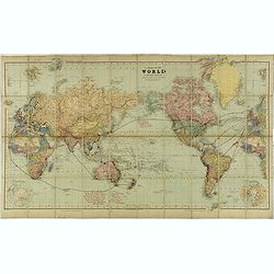
A Chart of the World on Mercator's Projection Shewing the Principal Ocean Steam Routes, the Submarine Telegraphs &c.
Charming, folding world map on Mercator's projection showing extensive steam routes and underground and undersea telegraph cables. The map is annotated in blue and red wi...
Place & Date: London, ca. 1890
![[No title] 'Daniel's Dream Map' or 'Wittenberg World Map'.](/uploads/cache/34785-250x250.jpg)
[No title] 'Daniel's Dream Map' or 'Wittenberg World Map'.
Wood block print engraved by the famous engravers Jost Amman and Virgil Solis - with their initials in lower bottom of the map. This somewhat curious map of Europe, Afric...
Place & Date: Cologne, ca. 1564
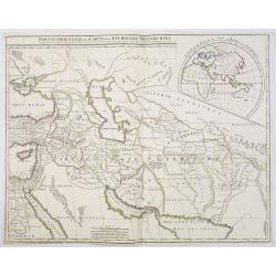
Partie Orientale de la Carte des Anciennes Monarchies. . .
This map depicts the eastern part of the Ancient World, Partie Occidentale de la Carte des Anciennes Monarchies including the Near East, Cyprus, Black Sea, Caspian Sea, I...
Place & Date: Paris, ca. 1800
![[No title - Daniel's Dream map]](/uploads/cache/34784-250x250.jpg)
[No title - Daniel's Dream map]
Wood block print engraved by the famous engravers Jost Amman and Virgil Solis - with their initials in lower bottom of the map. This somewhat curious map of Europe, Afric...
Place & Date: Cologne, ca. 1564

Le globe terrestre representé en deux plans-hemispheres, Dressé sur la Projection de Mr. De la Hyre...
“This splendid GlobeTerrestre originally published by J.B. Nolin is one of the finest large-scale world maps to be produced and is a fitting bridge between the geograph...
Place & Date: Paris, c. 1780
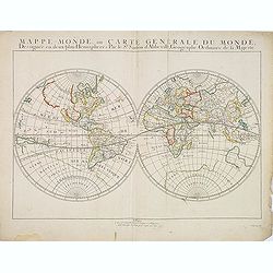
Mappe-Monde, ou Carte Generale du Monde: Dessignée en deux plans Hemispheres Par le Sr. Sanson d'Abbeville, Geographe ordinaire de sa Majesté.
Sanson's first world maps, dated 1651 and 1652, were issued separately and then in collections of mapsThe map is one of the first to distinguish the Great Lakes, all five...
Place & Date: Paris, 1651