Browse Listings in Europe

Beschrijvinge vande de zee Cuften va Vlanderen en Picardien. . .
DUTCH TEXT EDITION. A detailed chart of the coast of Flanders and Normandy decorated by a large colorful baroque title cartouche, and the coat of arms of Flanders with a ...
Place & Date: Leiden, Plantijn, 1585

Paris.
A spectacular panoramic view of Paris, with legends numbered from 1-70 in French. With the title in a banderol.After a design by Friedrich Bernhard Werner (1690-1776) who...
Place & Date: Augsburg, ca. 1740

Poloniae, Lituaniaeq descriptio.
Fine general map of Poland. Rare; the second plate appearing in the post-1595 edition of the Theatrum. Only used until 1612.Based on the now-lost map of Waclaw Grodecki. ...
Place & Date: Antwerp, 1612
![Dépt. De L'Aude. N°10. [ Carcassonne ]](/uploads/cache/27089-250x250.jpg)
Dépt. De L'Aude. N°10. [ Carcassonne ]
Map of the Aude region, centered on the town of Carcassonne. Reaching to the right till the Mediterranean.Lovely map from one of the last decorative atlases of the ninete...
Place & Date: Paris, A. Combette, 1852

Carte de la Coste de La Rochelle a Brouaige et de l'Isle d'Oleron Observee par le S.r de Chattillon ingenieur du Roy.
Map of the island of Oléron, with an inset in lower left corner showing the route of an English fleet to La Rochelle. At the time of mapping the area was a stronghold of...
Place & Date: Paris, 1627

Plan de la Ville et Port d'Antibes.
An attractive chart centered on the Mediterranean. With a scale and large compass-rose. Dated 1727, with the privilege of the King. From : Recueil des Plusieurs plans des...
Place & Date: Marseille, 1730

Picardie Meridionale Le Cambresis et leurs Environs.
Map showing the region of Picardie in Northern France. Including the towns of Abbeville, Amiens, Compiegne, Soisson, Chambray, etc.
Place & Date: Paris, 1737
![[Crimea]. Carte de la Cromée.](/uploads/cache/25719-250x250.jpg)
[Crimea]. Carte de la Cromée.
Mapmaker, Captain Jan Hendrik van Kinsbergen (1735-1819). Published by H. Friesman in 1787. This map first appeared in 1776 and was the first Russian map of the newly ann...
Place & Date: Amsterdam, H. Frieseman, 1787
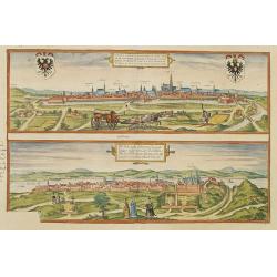
Vienna.. / Buda..
Pair of views on one sheet, the first showing the Austria capital of Vienna with fields, and figures in the foreground.Lower view shows the Hungarian capital of Budapest....
Place & Date: Cologne 1580
![Anverpia, nobile in Barbantia oppidum, parrim maritimum . . . [Antwerp]](/uploads/cache/26518-250x250.jpg)
Anverpia, nobile in Barbantia oppidum, parrim maritimum . . . [Antwerp]
The bird's-eye plan provides an excellent view of the citadel, city, docks and fortifications. The city was defended by a line of fortification and a moat constructed und...
Place & Date: Cologne, 1585