Browse Listings in Africa

Isola di Madagascar o di S. Lorenzo Scoperta dà Portoghesi nell anno 1506. . .
Decorative and highly detailed map of Madagascar, including 2 decorative cartouches and other embellishments.The remarkable Vincenzo Coronelli (1650-1718), was a Francisc...
Place & Date: Venice, 1690

Africa juxta navigationes et observat recentissimas. . .
Miniature map of Africa, a reduction of the Seutter folio map based on Homann''s cartography of 1715. Very detailed - much of it fictitious. The Nile is shown not only or...
Place & Date: Augsburg, J.M.Will, 1778
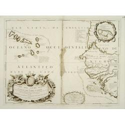
Bocche del Fiume Negro et Isole di Capo Verde.
Double-page engraved map of the Cape Verde Islands and part of the coast of Senegal, with large decorative cartouche. One with inset of the island Goree. During three cen...
Place & Date: Venice, 1690

Pas-Kaat vaneen gedeelte van de Aethiopische Zee behelsende de Kusten Zanguebar, Ajan en Abex, en een gedeelte van de Arabische Kust. . .
A finely engraved and detailed chart of the most eastern tip of Africa, including Somalia, Djibouti, Yemen, Mauritius, and many other islands in the Indian Ocean.Very rar...
Place & Date: Amsterdam, 1753
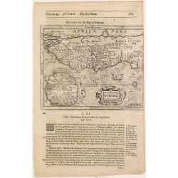
Guinea.
Samuel Purchas' edition of the Mercator/Hondius Atlas Minor . Map of Guinea published in his famous collection of voyages His Pilgrimes . With descriptive text in English...
Place & Date: London, 1645
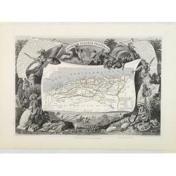
Algérie, Colonie Française. N°87.
Map of Algeria.Lovely map from one of the last decorative atlases of the nineteenth century.The rather simple map is framed by medallion portraits and coats of arms, and ...
Place & Date: Paris, A. Combette, 1852
![Carthage, etc. [Foliu XL ]](/uploads/cache/26122-250x250.jpg)
Carthage, etc. [Foliu XL ]
VERSO: Portraits of scholars, and an imaginary view on Carthage in Tunisia (12x17cm.) Page from the famous Liber chronicarum of Hartmann-Schedel 1493, the first and Latin...
Place & Date: Nuremberg 12 July 1493

Carte de L\'Egypte de la Nubie de L\'Abissinie. . .
Prepared by G.de l'Isle. Uncommon issue by Hendrik de Leth. Very detailed map of northeastern Africa, the Red Sea and the Arabian peninsula shows the political divisions ...
Place & Date: Amsterdam, 1740