Search Listings matching "australia" in Map Types
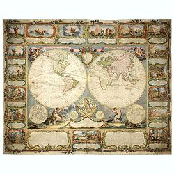
Mappemonde contenant les parties connues du globe terrestre dressée suivant de nouvelles observations
Wall map of the world in two hemispheres printed on two sheets, depicting the Eastern and Western hemispheres supported by two male figures, decorated at the bottom right...
Place & Date: Paris, Longchamps et Janvier, 1754

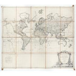
A chart of the China Sea inscribed to Monsr. D'APRES de MANNEVILLETTE .. To A.Dalrymple.
This most important milestone chart is based upon the surveys made from navigational surveys by Alexander Dalrymple (1737-1808]. He was the first hydrographer of the Brit...
Place & Date: Paris, ca 1775

Le globe terrestre representé en deux plans-hemispheres, Dressé sur la Projection de Mr. De la Hyre...
“This splendid GlobeTerrestre originally published by J.B. Nolin is one of the finest large-scale world maps to be produced and is a fitting bridge between the geograph...
Place & Date: Paris, c. 1780
Mappemonde ou carte générale du globe terrestre dessinée suivant les règles de la projection des cartes réduites…
Large world map showing the sea tracks of Captain Cook in his three Pacific voyages published by C. F. Delamarche.Rare state 4, dated 1786, of this large world map, featu...
Place & Date: Paris, Robert de Vaugondy/Delamarche, 1786
![[Set of five maps] Carte Générale de la Terre ou Mappe Monde](/uploads/cache/41145X-250x250.jpg)
[Set of five maps] Carte Générale de la Terre ou Mappe Monde
Rare and decorative set of five wall maps of the world and the four continents, prepared by Clouet, in very fine bright contemporary coloring. Each map ca. 965 x 1230 mm ...
Place & Date: Paris and Cadiz, Mondhare, 1785-1793

Plan de la Baie de L'Adventure. . .
A French maritime chart of Adventure Bay in S.E. Tasmania. Adventure Bay is the name of both a township and a geographical feature on the eastern side of Bruny Island. Th...
Place & Date: Paris, ca 1807

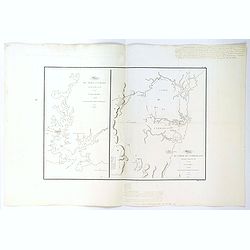
Plan du Port du Sud de la Baie de la Recherche / Croquis de la Baie des Moules. . .
A French maritime charts of the Port du Sud in Research Bay and the mouth of the Bay of Mussels, both in southern Tasmania. This is the edition of the extremely rare atla...
Place & Date: Paris, ca 1807
Plan du Port Jackson / Plan du Comte de Cumberland.
Two maps on one sheet showing the earliest scientific surveys of Port Jackson and the area surrounding Sydney Harbour, undertaken by the French in 1802. This is the editi...
Place & Date: Paris, 1807

Plan de L'Isle de Paque / Plan de la Baie de Cook.
Two engraved maps and four coastal profiles of Easter Island in the Pacific. First published in the Atlas du Voyage de la Perouse. This is the edition of the extremely ra...
Place & Date: Paris, 1797-1807
![[Title page] Voyage de découvertes aux terres Australes éxécuté par ordre de S.M l'Empereur et Roi.](/uploads/cache/39732-250x250.jpg)
[Title page] Voyage de découvertes aux terres Australes éxécuté par ordre de S.M l'Empereur et Roi.
Set of two title pages from the atlas part of "Voyage de decouvertes aux terres australes", Freycinet and Peron's accounts of the French cartographic expedition...
Place & Date: Paris, Langois, 1811
![[Title page] Voyage de découvertes aux terres Australes . . . Deuxieme partie.](/uploads/cache/46363-250x250.jpg)
[Title page] Voyage de découvertes aux terres Australes . . . Deuxieme partie.
Title page of the atlas Voyage de découvertes aux terres Australes by François Péron, 1824. The French expedition under Nicolas Baudin, was commissioned to chart the c...
Place & Date: Paris, 1807-1816

North Pacific.
Huge three sheet so-called Blue-back sailing chart of the Northern Pacific including China, Korea (with Matu Is. and Liancourt), Japan, Philippines, Kamchatka, Hawaii, Al...
Place & Date: London, 1868

Atlas Geographique. (Puzzle).
Three map puzzles, each measuring 25 x 33 cm., housed in the original color printed card case. Geographical jigsaw puzzle set comprising three maps (world, Europe and Fra...
Place & Date: Paris, ca. 1910