Browse Listings in Europe

Porte de Harlem (Heemstede/Haarlem)
Showing the Haarlemmer Poort (gate) in Heemstede near Haarlem. Likely published by Mondhard, who was a well-known publisher of optical prints, established in rue St.Marti...
Place & Date: Paris, ca. 1750

Cazal. (Casale Monferrato)
A rare panoramic of Casale Monferrato in the Piedmont region. Engraved by Pierre Aveline (Paris, c.1656 - 23 May 1722). He was also a print-publisher and print-seller. H...
Place & Date: Paris, 1690-1730
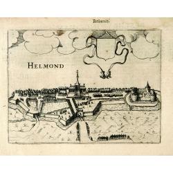
Helmond.
A panoramic view of the Helmond, seen from the Kromme Steenweg .
Place & Date: Arnhem, 1613

VI. Partie du Duche de Gueldre où se trouve la Veluwe.
Attractive small map covering the northwestern part of Gelderland. In the center "'t Loo". From Atlas Portatif Universel, by Robert de Vaugondy.Unrecorded state...
Place & Date: Paris, later than 1748

Royaume de Bohéme, Marquisat de Moravie, et Silésie Autrichenne.
Small detailed map of today Czech Republic. From Atlas Portatif Universel, by Robert de Vaugondy.Unrecorded state with erased date. Page 32 outside border top right. Mary...
Place & Date: Paris, later than 1749

ANTIBES, Ville et Port de Mer de Provence, sur la Mer Mediterranée.
Early plan of Antibes. From his "Introduction à la fortification".
Place & Date: Paris, 1693

(Postcard of Europe)
During the Great War, when the only means of communicating news to the masses was by newspapers and weekly illustrated magazines, the ‘war’ or 'military' picture post...
Place & Date: Moscow, 1914

Franciae orientalis../ Monasteriensis et osnaburgensis..
From 'Theatrum Orbis Terrarum [Atlas of the Whole World]' published in Antwerp. French text on verso.The map of Frankenland is prepared by Sebastian Rotenhan (1478-1532) ...
Place & Date: Antwerp, c.1574

Die Zyp / La Zype.
A miniature map showing the polder of De Zype. Title cartouche in the upper side.First published in 1598 in his Caert-Thresoor, the plates were executed by the most famou...
Place & Date: Amsterdam / Frankfurt, 1609

s'Lands en Oost-Indische Lynbanen. & t'Oost-Indisch-Huys.
A decorative print of the Lynbanen a place were V.O.C. ship riggings and ropes were produced and kept.
Place & Date: Amsterdam, 1760-1767