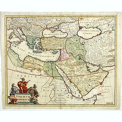
Turcicum Imperium.
Detailed map of the Turkish Empire by Holland's leading mapmaker at the end of the seventeenth century. The cartouche shows an Ottoman administrator or possibly the Sulta...
$750 / ≈ €662
Place & Date: Amsterdam, 1680

A Map of the Environs of Constantinople Drawn from a great number of accurate astronomical & geographical manuscripts and printed documents, by A. Arrowsmith 1801 and 1804.
Arrowsmith’s large and detailed map of the Ottoman Empire and the Black Sea, with Cyprus, Crete and the Greek Islands in the Mediterranean Sea, Albania, Bosnia and Herz...
$4000 / ≈ €3531
Place & Date: London, No.10 Soho Square, 4th September 1804