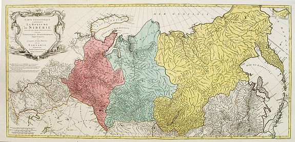
Description
Scale ca. 1 : 13,000,000 and engraved by Matthäus Albrecht Lotter (1741 Augsburg 1810) for Tobias Conrad Lotter (1717 Augsburg 1777).
The map has no date but can be dated 1770-1780. In about 1770 a map of Siberia by Ivan Fomic Truscot (1721-1786, comp. BMC XXII, 353) was published, that, however, comprised the West Siberian states Tobolsk and Yeniseiesk only, but may have been quite available to Lotter, just as also the German edition of the third Russian general map by Truscot and Jacob F. Schmidt of 1776 was published by Lotter in 1784.
The comparison of the Asian northeastern coast from Japan up to Cape Szalaginskoi (Cape Shelagskiy) together with the offshore islands there results in an astonishing similarity with representation and designation on Rigobert Bonne’s maps of Russia and the Chinese Tartary published by Lattré in Paris in 1771. Especially striking the form of Sakhalin that hitherto – but also still on the Truscot map of 1776 – appears far more stocky, here though shows a slimmer shape considerably closer to reality.
Cape Patience known at least since the 1743 Utrecht edition of the map of Russia by Johann Matthias Haas (Augsburg 1684 – Wittenberg/Augsburg 1742) – Kaert van Het geheele Russische Keizerryk – already published by Homann Heirs in Nuremberg in 1730 + 39 here supposedly for the first time shown in unity with Sakhalin and, as the long-stretched southern half beginning west of the cape already recognizable there is missing here, together forming its southern tip.
Of great similarity, too, the still completely bulky representation of Jeso (= Hokkaido), filling up large parts of the Sea of Japan as known sufficiently from numerous, though by far not all maps of the 18th century. The Kurile Islands adjacent in northeastern direction – with rich detail designation, but without the denomination as chain of islands appearing at least in the 1784 edition of Truscot’s general map – with the obscure islands Terre des Etat (Iturup) and Terre de la Compagnie. Both, as also the often furthermore adjacent da Gama Land, had been supposedly finally left by Truscot to the memory of the great time of sometimes only vague discoveries.
Interestingly both islands are designated with hints to Russian maps in question marks. This probably to be seen as a sign for an independent work of Lotter who obviously drew his knowledge from different sources and not just copied a map he had got into his hands for a German edition. Further clue to the dating is, too, the taking over of the Chukchi (Chukotsk) Peninsula in the farest northeast of Asia in the shape practically unchanged since Ivan Kirilov’s (1695 – Samara 1737) general map of 1734 – the first Russian one at all. For at the latest since publishing the Truscot map of 1776 in 1784 Lotter would have known the new shape valid till today.
Likewise Novaya Zemlya here still figuring as undivided island, thus without the Matochkin Strait supposedly recorded by Truscot for the first time. With respect to the independence of his work a recourse to older forms of representation appears not very likely in both cases.
Designed in cone projection, the null meridian runs about 020degrees western longitude of Greenwich through the center of Iceland. In the west reaching till Novaya Zemlya – Ural Mountains – Kazan – Sea of Azov, the map comprises in the far east still northern Japan , the Kurile Islands and Kamchatka including the offshore Bering Island . Southerly still with at the Caspian Sea , Lake Aral , the headwaters of the Yenisey , the Dalai nuur (Hulun Lake) in northern Mongolia near to the wall of Genghis Chan , the region of today’s Vladivostok and the Tsugari Street . In the Arctic Ocean up to 78 degrees northern latitude. [text by Lüder H. Niemeyer]
Reference: Grenacher, Guide to the cartographic history of the imperial city of Augsburg, Imago Mundi XXII, 85 ff.
FAQ - Guarantee - Shipping
Buying in the BuyNow Gallery
This item is available for immediate purchase when a "Add to Cart" or "Inquire Now" button is shown.
Items are sold in the EU margin scheme
Payments are accepted in Euros or US Dollars.
Authenticity Guarantee
 We provide professional descriptions, condition report and HiBCoR rating (based on 45 years experience in the map business)
We fully guarantee the authenticity of items we sell. We provide a certificate of authenticity for each purchased item.
Condition / Coloring
We indicate the condition of each item and use our unnique HiBCoR grading system in which four key items determine a map's value: Historical Importance, Beauty, Condition/Coloring and Rarity.
We offer many maps in their original black and white condition. We do not systematically color-up maps to make them more sellable to the general public or buyer.
Copper engraved or wood block maps are always hand colored. Maps were initially colored for aesthetic reasons and to improve readability. Nowadays, it is becoming a challenge to find maps in their original colors and are therefor more valuable.
We use the following color keys in our catalog:
Original colors; mean that the colors have been applied around the time the map was issued.
Colored; If the colors are applied recently or at the end of the 20th century, then "colored", or "attractive colors" will be used.
Original o/l colors; means the map has only the borders colored at the time of publication.
Read more about coloring of maps [+]
FAQ
Please have a look for more information about buying in the BuyNow gallery.
Many answers are likely to find in the general help section.
Virtual Collection
![]()
With Virtual Collection you can collect all your favorite items in one place. It is free, and anyone can create his or her Virtual map collection.
Unless you are logged in, the item is only saved for this session. You have to be registed and logged-in if you want to save this item permanently to your Virtual Collection.
Read More [+]
Registering Here, it is and you do not need a credit card.
Add this item to
Virtual Collection
or click the following link to see my Virtual Collection.
Invoice
The invoice and certificates of authenticity are available in the client center >Invoices
| High-Resolution Digital Image Download | |
|
Paulus Swaen maintains an archive of most of our high-resolution rare maps, prints, posters and medieval manuscript scans. We make them freely available for download and study. Read more about free image download |
Click this image for a free HR-image download. |
In accordance with the EU Consumer Rights Directive and habitually reside in the European Union you have the right to cancel the contract for the purchase of a lot, without giving any reason.
The cancellation period will expire 14 calendar days from the day after the date on which you or a third party (other than the carrier and indicated by you) acquires, physical possession of the lot. To exercise the right to cancel you must inform Paulus Swaen Europe bv, which is offering to sell the lot either as an agent for the seller or as the owner of the lot, of your decision to cancel this contract by a clear statement (e.g. a letter sent by post, or e-mail (amsterdam@swaen.com).
To meet the cancellation deadline, it is sufficient for you to send your communication concerning your exercise of the right to cancel before the cancellation period has expired.