Subscribe to be notified if similar examples become available.
A General Map of the World or Terraqueous Globe, with all the New Discoveries and Marginal Delineations, Containing the Most Interesting Particulars in the Solar, Starry and Mundane Systems |
||||||||||||||||||||
|
||||||||||||||||||||
|
|
||||||||||||||||||||
Estimated value: $3800 - $4800 |
||||||||||||||||||||
Description
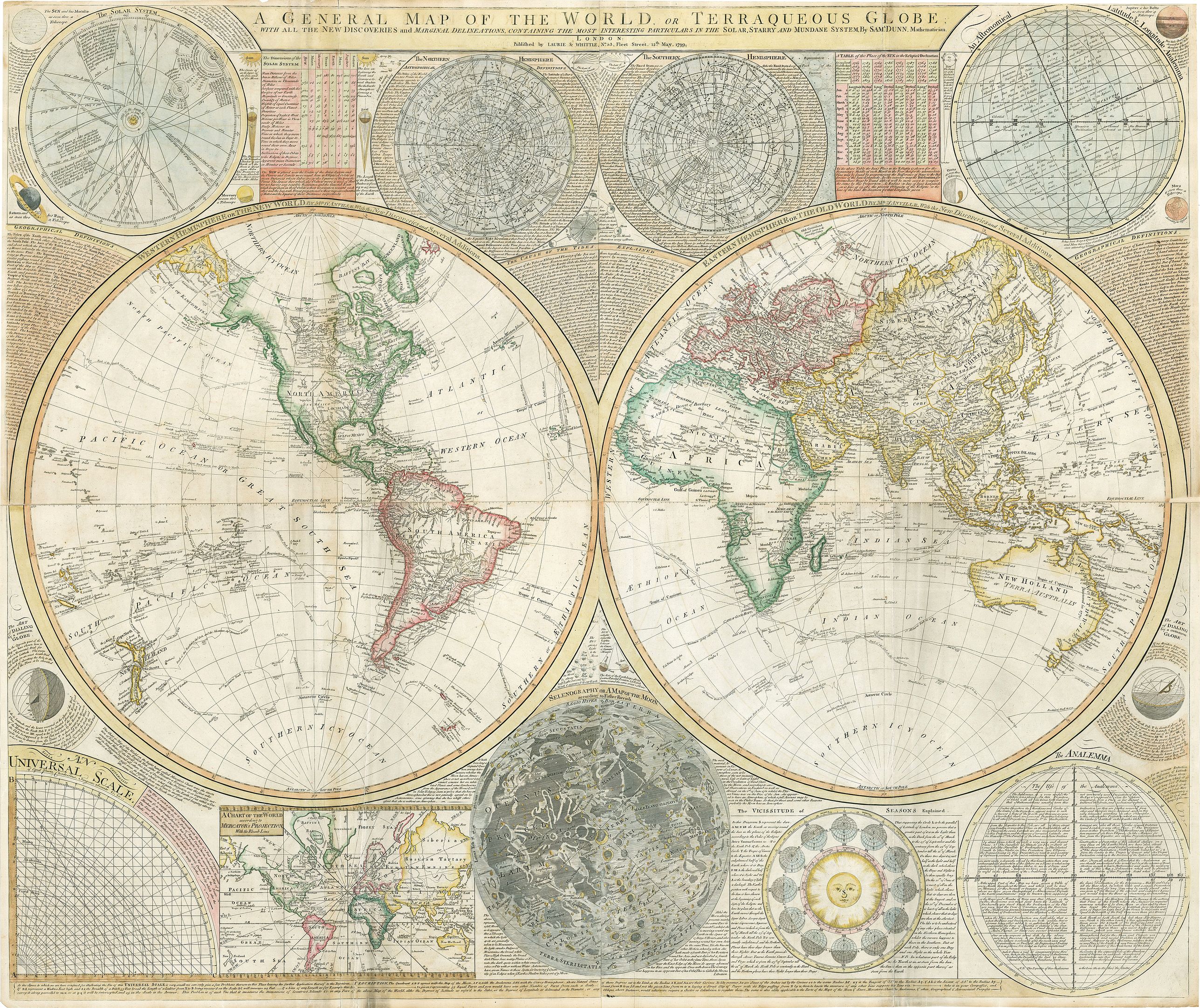
A remarkable large format world map featuring the most recently attained cartographic information and most advanced celestial diagrams of the era. Samuel Dunn's monumental map stands out among its contemporaries with a unique balance of beauty and presentation of data that makes is easily recognizable among collectors.
In North America, the United States is shown to extend west to the Mississippi as the Louisiana Purchase would not happen until 1803, expanding United States land claims to the Pacific and prompting the famed expedition of Lewis and Clark. Therefore, much of the interior of this continent is unknown and left to speculation. In the location the Rocky Mountain states of Colorado, Wyoming, and Montana is a note explaining the sources of the Arkansas, Missouri, and Mississippi Rivers to be unknown.
In Canada, much of the information comes as a result of the lucrative fur trading industry, then dominated by the Northwest and Hudson Bay Company. This includes the locations of many lakes, rivers, and Native American Tribes. The coastline of the Pacific Northwest is attributed to "Vancouver's Discoveries," and in the far north, two small delineations of coastline are noted to have been seen by Hearn (1772) and McKenzie, (1786). This vast region that is the Canadian Archipelago would be heavily explored by the British for the next half century, leading to little fame and fortune but a tremendous amount of peril, starvation, death, and in one case, cannibalism (Franklin Expedition of 1845).
Many of the other continents have areas in their interior yet to be explored by Europeans. While earlier maps would fill these empty spaces with speculative lakes, mountains, cities, and vignettes of animals, cannibals, or giants, Dunn chooses to leave these areas blank. This alternative approach had become ever more common among map makers of the 18th century. Simply put, if you don't know what exists in a space on the map, leave it blank. For this reason, we find many of these blank spaces in the interior of South America, Africa, and New Holland (Australia), all of which have more to be desired in the delineation or in the case of Australia, completion of their coastlines.
The last example of leaving out what is unknown can be found with the lack of a southern continent (Antarctica). While mankind had visual confirmation of its existence with the 1820 sighting by Fabian Gottlieb von Bellingshausen and the first landing in 1851 by the American sealer Mercator Cooper, its coastline was largely unknown and therefore omitted from the map. But where the map lacks in an Antarctic coastline, it fills the southern seas with tracks of voyages and notes of sightings of ice fields, isles, and sheets mistaken for land.
Voyages of Captain Cook
As previously stated, the map offers some of the latest cartographic information of the era. This state in particular includes the track and discoveries of the all three voyages of Captain Cook with dates of notable events and sightings. Arguably the most famous voyage was his third expedition (July 12, 1776 – October 4, 1780), that took the the Resolution and Discovery to the northern reaches of the Pacific Ocean where them map notes "Impenetrable Ice extending from Continent to Continent, Aug. 18th 1778." Additionally, the map indicates the location and date where Captain Cook was killed in Owhyhee, Feb. 1779. To the east of this location are several islands with a note explaining that that while they appear on Spanish maps and are supposed to be the same islands, they in fact do not exist.
Celestial Charts and Diagrams
This massive wall map of the world dedicates every space outside of the map to a wide array of celestial charts and diagrams, with text explaining in detail the science, discoveries, and theory behind each image. At top center, a double-hemisphere astronomical map shows the constellation of the northern and southern hemisphere. The top left corner is adorned with a map of the solar system showing the orbital paths of all known planets and comets or "blazing stars," noting their date of observation. At the bottom center, we find a prominent map of the Moon according to Father Riccioli and to the right is an interesting diagram explaining the changing seasons in relation to our sun, which is presented with a face. Additional planets such as Mars, Venus, Jupiter, and Saturn are scattered throughout the outside spaces of the map.
FAQ - Guarantee - Shipping
Buying in the BuyNow Gallery
This item is available for immediate purchase when a "Add to Cart" or "Inquire Now" button is shown.
Items are sold in the EU margin scheme
Payments are accepted in Euros or US Dollars.
Authenticity Guarantee
 We provide professional descriptions, condition report and HiBCoR rating (based on 45 years experience in the map business)
We fully guarantee the authenticity of items we sell. We provide a certificate of authenticity for each purchased item.
Condition / Coloring
We indicate the condition of each item and use our unnique HiBCoR grading system in which four key items determine a map's value: Historical Importance, Beauty, Condition/Coloring and Rarity.
We offer many maps in their original black and white condition. We do not systematically color-up maps to make them more sellable to the general public or buyer.
Copper engraved or wood block maps are always hand colored. Maps were initially colored for aesthetic reasons and to improve readability. Nowadays, it is becoming a challenge to find maps in their original colors and are therefor more valuable.
We use the following color keys in our catalog:
Original colors; mean that the colors have been applied around the time the map was issued.
Colored; If the colors are applied recently or at the end of the 20th century, then "colored", or "attractive colors" will be used.
Original o/l colors; means the map has only the borders colored at the time of publication.
Read more about coloring of maps [+]
FAQ
Please have a look for more information about buying in the BuyNow gallery.
Many answers are likely to find in the general help section.
Virtual Collection
![]()
With Virtual Collection you can collect all your favorite items in one place. It is free, and anyone can create his or her Virtual map collection.
Unless you are logged in, the item is only saved for this session. You have to be registed and logged-in if you want to save this item permanently to your Virtual Collection.
Read More [+]
Registering Here, it is and you do not need a credit card.
Add this item to
Virtual Collection
or click the following link to see my Virtual Collection.
Invoice
The invoice and certificates of authenticity are available in the client center >Invoices
| High-Resolution Digital Image Download | |
|
Paulus Swaen maintains an archive of most of our high-resolution rare maps, prints, posters and medieval manuscript scans. We make them freely available for download and study. Read more about free image download |
Click this image for a free HR-image download. |
In accordance with the EU Consumer Rights Directive and habitually reside in the European Union you have the right to cancel the contract for the purchase of a lot, without giving any reason.
The cancellation period will expire 14 calendar days from the day after the date on which you or a third party (other than the carrier and indicated by you) acquires, physical possession of the lot. To exercise the right to cancel you must inform Paulus Swaen Europe bv, which is offering to sell the lot either as an agent for the seller or as the owner of the lot, of your decision to cancel this contract by a clear statement (e.g. a letter sent by post, or e-mail (amsterdam@swaen.com).
To meet the cancellation deadline, it is sufficient for you to send your communication concerning your exercise of the right to cancel before the cancellation period has expired.