Antique maps of Korea
Paulus Swaen Old Maps and Prints is one of the world's leading map dealers, offering fine antique maps and artifacts related to Korea and Asian countries.
The company was founded in 1987 by Pierre Joppen, who remains the owner and CEO. Over the last decades, several business trips have taken us to South Korea, Japan, Singapore, and Hong Kong.
We keep an inventory of fine maps of Korea, items relating to the East Sea, globes, instruments, and maritime charts. Please take a look at some of our items currently available for sale, or read our 2-minute articles about Korean ancient mapping.
Please get in touch with us if you have any questions or would like to meet us on one of our upcoming visits to South Korea.
No ancient maps of Korea are extant today. However, several references are made to the existence of earlier maps in history books such as Kim Pu-shiks Samguk Sagi (History of the Three Kingdoms, 1145 AD.) and Monk Iryon's Samguk Yusa (Legends and History of the Three Kingdoms of Ancient Korea, c.1270 AD.).
Furthermore, these records are not very detailed as to the contents of the maps. Accordingly,y we may say that all the old maps extant in Korea were made during the Yi dynasty.
The oldest existing map of Korea is Kwon Kun's (1352-1409 AD.) Hanil Gangni Yokdae Kukdo Chido (Map of the Territories of the Old World with the Capitals of Countries in Successive Ages). Kwon Kun's map, which was completed in 1402 AD., is not only the oldest one existing today, but also indicates the nature of two other maps which are only mentioned in records: i.e., Map of the Five Provinces and Two Regions of Korea made in the Koryo dynasty and Map of the Eight Provinces of Korea made by Yi Hoe in the early days of the Yi dynasty.
Another old map of Korea, Map of the Eight Provinces, was reportedly contained in Tongguk Yoji Sangnam, (Detailed Geography of the Kingdom of the East, c.1424 AD), composed of 50 volumes, none of which remain today. However, the preface of this book is retained in Sinjong Tongguk Yoji Sungnam, a revised and supplemented edition of Tongguk Yoji Sungnam. Sinjong Tongguk Yoji Sangnam, completed in 1530 AD. and extant today with minor subsequent revisions, contains the Map of the Eight Provinces.
Another old map is Chang Sang-gi's (1678-1752 AD.) Tongguk Chido (Map of Korea), which is thought to have been influenced by Kwon Kun's map-making method.
All versions of Chong Sang-gi's Tongguk Chido are manuscript maps consisting of a map of the whole of Korea and individual maps of the provinces. Chong Sang-gi
used a scale of 100 Ii (about 40km) to one Korean foot for the plains and 120 or 130 Ii to one Korean foot for the mountainous areas.
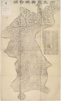
Kim Chong-ho's Ch'onggudo (Map of Korea) and Taedongyo Chido (Atlas of the Great East Kingdom) are probably the most noteworthy old maps made in Korea before Western cartography was introduced.
In 1834, an atlas of Korean maps includes the author's explanatory notes, a map of various provinces in ancient Korea, a map of four provinces and the Three Han Kingdoms of Korea, and a map of the eight provinces of Korea. Kim Chong-ho, who had a precise knowledge of modern longitude and latitude, made a grid system, measuring 100 Ii for north-south and 70 Ii for east-west directions. He had the area covered by a map divided into grid sections in order to make the scale equal for all areas on the map, which was presented on a single page of his atlas. However, this grid system seems to have had no relationship to the contemporary geographical longitude and latitude.
Twenty-seven years after the completion of Ch'onggudo, Kim Chong-ho published the first edition of Taedongyo Chido in 1861 in wood-block printing and the second edition in 1864.
Taedongyo Chido was later found to be so accurate and detailed that it served as a basis for the production of 1/50,000-scale maps completed in 1920 using the modern triangulation method.
Extracted from"A Handbook of Korea"; published 1978; by KOIS.
 Kim Jeong-ho (pen name Gosanja; 1804-1866?)
was a Korean geographer and cartographer. Beginning in 1830, Kim traveled through Korea for 30 years, gathering information.
In 1864, he published a large woodcut map, the Taedonyo Jido.
The map was drawn at a scale of 1:162,000. It contains more than 11,600 essential pieces of information in the areas of natural, political, economic, military and cultural fields, such as mountains and mountain ranges, rivers, streams, islets, ports, sea routes, district administrative seats and their boundaries, residential districts, traffic networks, signal-fire sites, communications, walled cities, markets, storehouses, stock farms, irrigation channels
and historic relics.
It consists of 22 sheets totaling 33 square meters and is designed to be folded for convenience and printed in quantities that make it available to the public.
It was so accurate that it provided the basis for the 1:50,000-scale maps produced by modern triangulation methods in 1920. It was made as 22 volumes containing sequential fold-out maps of the Korean peninsula.
Each plate was hand-carved from 60 double-sided tablets of the hardwood Linden Tree (Tilla amurensis).
Only 15 woodblock tablets remain at the National Museum of Korea, while one piece is at Sungsil University Museum. Kim Jeong-ho was able to make the Taedong yeojido. With the support of high officials like Din Hŏn, he gained access to the government's maps and to geographical materials in the hands of Ch'oe Hangi and Ch'oe Sŏnghwan. After founding the Taedong yŏjido, Kim began compiling the Taedong chiji (Geography of the Great East), a project that continued until the end of his life. (Han Young-woo, in Early Korean cartography, pag.85)
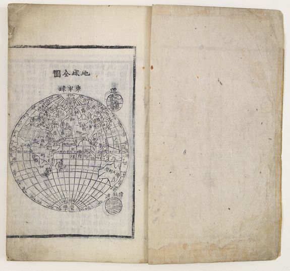
Ch'onha chido [Atlas of all under Heaven]
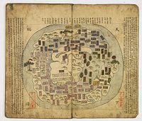 The Ch’onha chido is a 19th-century copy of the traditional Korean atlas produced in the early
Choson dynasty (1392-1910). The first map in the atlas, "Ch’onhado" (Map of the world), is a unique and popular China-centered world map seen in the Korean perspective.
The Ch’onha chido is a 19th-century copy of the traditional Korean atlas produced in the early
Choson dynasty (1392-1910). The first map in the atlas, "Ch’onhado" (Map of the world), is a unique and popular China-centered world map seen in the Korean perspective.
The typical contents of the traditional Korean atlases during this period consist of the following: a world map bearing the title Ch’onhado, with China, Korea, Japan and the Ryukyus at the center, surrounded by a ring of islands and other landforms that become increasingly mythological with distance from the center.
The second map depicts China and Korea, the Ryukyu Islands, Korea, and the eight provinces of Korea. The style and arrangement of the provincial maps is ultimately derivative of the Sinjung tongguk yoji sungnam, as is common for both printed and manuscript atlases of the latter Choson period.
Such atlases included, typically, also maps of the provinces: Chunggukto -- Ilbon'gukto -- Yugugukto -- Tongguk p'alto taech'ong -- Hamgyŏng-do -- P'yŏngan-do -- Hwanghae-do -- Kangwŏn-do -- Kyŏnggi-do -- Ch'ungch'ŏng-do -- Kyŏngsang-do -- Chŏlla-do.
The map of China in this atlas prominently depicts the Great Wall and the Yellow and Yangtze rivers. This map may have been
derived from a map produced during the Chinese Ming Empire (1368-1644).
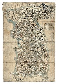
A Unique 18th-Century Korean Map
The only example from the Chosŏn dynasty on which notes and district names appear only in Hangul
by Prof. Gari Keith Ledyard.
 From the late Koryo dynasty to the last years of the Chosŏn dynasty, Korea had a rich cartographic history, producing thousands of beautiful national maps using a wide range of cartographic methods and styles. For their abundant notes and the indication of place names, the mapmakers used only Classical Chinese (Hanmun). That was the cultural standard of those times.
But sometime during the 18th century, an anonymous and probably self-trained cartographer decided to produce a map on which all the notes and place names would be written exclusively in Hangul.
As far as this author can determine, the anonymous mapmaker's map of Korea is the only example
from the Chosŏn dynasty on which notes and district names appear only in Hangul.
In this article, the author examines his style and methods.
The map measures 1030 x 630 mm, height to width. It is of about the same proportions as the
much larger and untitled "Naikau map" (1515 x 909 mm) of Korea held by the Japanese government's
Cabinet Library (Naikaku Bunko), which is considered the oldest known map in the Chong Ch'ok style, dating to the last quarter of the 15th century or is copied from a map of that period.
Unfortunately, the map bears neither title nor date, nor is there any indication of the identity of its maker.
But its cartographic type is well known and researched, being of the so-called Chong Ch’ŏk style, named after an official of many talents, Chong Ch’ok (1390-1475), who during the 15th century was a favorite of five kings, all of whom promoted geographical research and map-making.
The defining feature of maps in this style is the problematic depiction of Korea’s northern border with northeastern China.
The Korean orthography displayed in the place names on the map is typical of the 18th century, in general agreement with the evidence of place-name changes and the map's physical condition. Since the cartographic merits of the map are limited compared to earlier and well-known examples of the Chong Ch’ok genre, which are all in Chinese, the chief and unique feature of the Gabor map, that is, its exclusive use of Korean for district names and marginal comments, deserves analysis and comment.
Until the middle of the 15th century, there was no system for writing the spoken Korean language,
which is linguistically unrelated to Chinese.
However, as mentioned earlier, classical written Chinese was widely known and used among Korea's educated classes. It was not a spoken language, even in China itself. Korean methods for parsing a written Chinese text used special symbols for grammatical elements so that a subject could be distinguished from an object, or for verbal distinctions that clarified whether a clause was conditional or causative, a statement, a question, or a command, etc.
As far as this author can determine, the anonymous mapmaker's map of Korea is the only example
from the Chosŏn dynasty, on which notes and district names appear only in Hangul.
Read the full article in the 2013 East Asia Institute Special Report.
This map has been sold.
A Resumé of the Contents of the World
O HONG-MUK - Yojae ch'waryo [A Resumé of the Contents of the World] Korea, 1894. 83 xylograph printed text in Chinese characters, on 166pp. On rice paper. With nine double-page woodcut maps. Patterned yellow wrappers.Each page has 11 columns of text with geographical details, and many have distance charts. 9 double-page woodcut maps (1 double-hemisphere world map, eight maps of the provinces). Stitched in traditional concertina form within original patterned yellow paper wrappers. Unidentified ‘chop’ in red, repeated on five pages.
The world map is a typical Western form, whilst the provincial maps identify the principal towns, rivers, and administrative boundaries. The traditional form of construction of the atlas means that the fold in each map is at the outer margin rather than the inner, as is usual with western atlases. These Korean atlases were produced to train the Korean elite on geography, part of an educational tradition established in the 1850s.
The European Mapping of Korea
(1493 - 1880)
Korea was not known to Europe until after the 16th-century "Age of Discovery." It was long after Marco Polo made an account of his voyage, published in 1301 under the title of "Description of the World," which was widely circulated in Europe and became the principal source of European knowledge of Asia.
Starting in 1590, the 'Annual Letters' from Jesuit missionaries in the Far East began describing Korea in more detail, initially from indirect sources, via news from Father Gregorio de Cespedes, Korea's first European visitor. Geographical questions regarding Korea's relationship to Japan, China, and the Tartar regions to the north were beginning to be answered, including the division of Korea from China by the Yalu River.
The first Europeans to learn of Korea were the Portuguese. Since 1543, they had a trading post on the island of Hirado. During his investigations in Portugal and of the Portuguese merchant fleet, Jan Huyghen van Linschoten learned this from Dirck Gerritszoon Pomp, nicknamed
"Dirck China." Pomp, a Hollander, also in the service of the Portuguese, went to sea in 1584 aboard the Portuguese vessel "Santa Cruz". In 1598 Jan Huyghen van Linschoten published his "Itenerario".
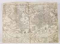 The world map created in 1594 by Petrus Plancius of the Netherlands is known to be the oldest surviving printed map in Europe to show an icicle-shaped Korean island marked "Corea." (There are two earlier maps, drawn by Bartholomeu Velho in 1562 and Lazaro Luis in 1563, that show the Korean Peninsula, but they gave no specific name to the peninsula.)
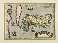 Luis Teixeira,
completed a new map of Japan in 1592 with Korea appearing as a large, carrot-shaped, island. In 1692, Teixeira sent his manuscript to Otelius in Antwerp, who published it in his atlas in 1595. The popularity of the Ortelius atlas led to this insular (Teixeira)-form being used for four decades by European map publishers.
Luis Teixeira,
completed a new map of Japan in 1592 with Korea appearing as a large, carrot-shaped, island. In 1692, Teixeira sent his manuscript to Otelius in Antwerp, who published it in his atlas in 1595. The popularity of the Ortelius atlas led to this insular (Teixeira)-form being used for four decades by European map publishers.
In 1646, Sir Robert Dudley’s hydrographic chart Dell’Arcano del Mare, (The Mysteries of the Sea), referred to Regno di Corai (the Kingdom of Korea).
Korea is an island !
Questions of how and why Korea came to be displayed as an island have never been satisfactorily answered.
The peninsula's natural border with China suggests that the Yalu River forms the western portion of the boundary. Its estuary is broad and navigable, emerging into Korea Bay of the Yellow Sea, as is the Tumen River, which forms the border on the east side.
Mariners may have navigated partway up these rivers, concluded that the two waterways joined to form a strait that reached from sea to sea, as was the case with California in the early seventeenth century.
If so, they had not proceeded far enough inland to observe Paektu San, a 2,744-meter mountain peak, the source of both rivers.
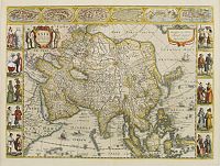 Jodocus Hondius, in his 1619 and 1629 maps of Asia, firmly attached a still slim Korean island to the Asian continent, thereby creating the first seventeenth-century printed atlas maps showing with certainty Korea as a peninsula.
Korea was, however, continuing to confuse European mapmakers, as the Blaeu's who introduced on the map of China a new shape for Korea with the southern two-thirds resembling a relatively accurate rectangular peninsula. However, at the top, it was compressed into an island, separated from the continent by a short, narrow strait.
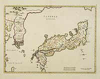 When the Martini/Blaeu map of Japan and Korea appeared in the China volume of Blaeu's atlas of 1655,
clearly depicting Korea as an unambiguous peninsula, the life of the island version was virtually brought to an end.
When the Martini/Blaeu map of Japan and Korea appeared in the China volume of Blaeu's atlas of 1655,
clearly depicting Korea as an unambiguous peninsula, the life of the island version was virtually brought to an end.
The shape of and information about Korea changed drastically when Hendrick Hamel and his companions returned from their adventures on the Korean peninsula. Though Hamel made no maps himself, his descriptions influenced cartographers of the country. Hamel landed on Cheju-do which appeared on Portuguese maps before as Ilha de Ladrones (island of thieves), but also the Mariana Islands were referred to as the Ladrones.
In this regard, it is interesting that Cheju Island existed under two different names and was considered two islands as well: Fung-ma and Quelpaert Island. Quelpaert is probably named after a type of galleon.
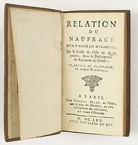
Hendrik Hamel sailed as the ship's secretary from Texel to Batavia on "De Sperwer" in January 1653. After visiting Batavia and Formosa, the ship set sail for Japan with the newly appointed V.O.C. governor for Korea, Cornelis Lessen, on board. Unfortunately, the shipwrecked at the coast of an unknown island near Korea, which they named the Isle of Quelparts. Many of the crew drowned. Those who survived, including Hamel, went ashore, where they were imprisoned by the Koreans and brought to the mainland, where they were held for no less than thirteen years.
In 1666, Hamel and a few of his companions escaped and reached Japan. In 1668, they returned to the Netherlands. Still, in the same year, the account of his misadventures was published at Rotterdam by Joh. Stichter. Hamel's account, which is the first Western eyewitness of Korea, became very popular, and was not only translated into French (in 1670), but also, in 1704 and 1732, into English with the title An account of the shipwreck of a Dutch vessel on the coast of the Isle of Quelpaert.
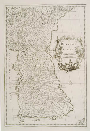
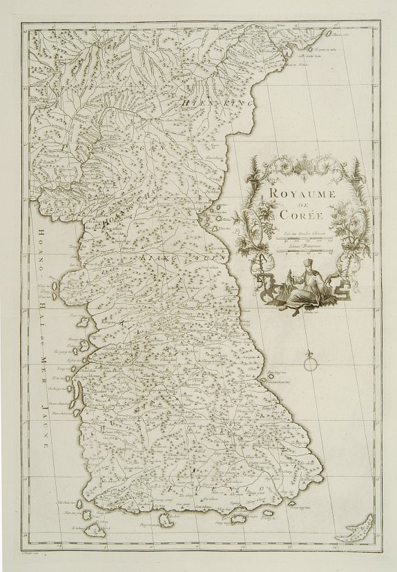
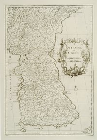 Jean-Baptiste Bourguignon d'Anville (1697-1782).
His map is of great importance to Korean cartography, as it made Korean cartography widely available in Europe. He published Nouvel Atlas de la Chine, published in The Hague in 1737, "The principal cartographic authority on China during the 18th century." (Tooley). d'Anville used maps prepared by Jesuit missionaries and commissioned by Emperor Kangxi.
Since the Jesuits were not allowed in Korea the "Tartar lord" (Mukedeng a troubleshooter and trusted assistant for the Kangxi emperor) made measurements and observations in the Manchurian and Korean regions in 1709 and 1710. He was accompanied by Father Jean-Baptiste Regis (1664-1738), Father Pierre Jartoux (1669-1720), and Erhernberg Xavier Fridelli (1643-1743). While in Korea, the team was under constant surveillance. The Tartar lord was, however, given a map, and Father Jean-Baptiste Regis produced a map that came out in the Kangxi atlas and was then used and edited by d'Anville and published in 1735 in du Halde (description de la Chine) and as "Royaume de Coree" (atlas de la Chine 1737). Du Halde was a French Jesuit and geographer of Paris.
Despite the broadening of the southern part of the peninsula, this map was, in the main, accurate and was widely copied in the next 150 years.
Sea of Korea
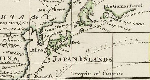 In most world maps and atlases used internationally today, the sea in between Korea and Japan is indicated as the "Sea of Japan". Korea supports the dual name "Sea of Japan - East Sea".
It is interesting to review the historical background of the term "East Sea" and how neighboring countries and other Western countries have recognized Korea's East Sea in the past.
Historically, Korea has used the term "East Sea" in writings since 59 B.C. The reference to the "East Sea" was also consistent in numerous maps created after the 18th century. Many geography textbooks published and used before the annexation of Korea by Japan in the early 20th century made reference to the "East Sea," "Sea of Choson" or "Sea of Korea."
Russian maps of East Asia were all created after 1639, when Russians first arrived on the Pacific coast region. In 1687, Nicolas Witzen's "Noord en Oost Tartarye" refers to the East Sea as "Oceanus Orientalis." N. Goman's 1725 map uses the term "Eastern Ocean," and in a 1734 map, I. Kirilov refers to the East Sea as "Vostochnoe," meaning "East Sea."
The Map of Asia printed by the renowned Petersburg Academy of Sciences in 1745 also refers to the East Sea as "Koreiskoe Mope," or "Sea of Korea." Other famous maps printed in Russia from 1745 to 1791 use the term "Sea of Korea".
Adam Johann von Krusenstern (1770-1846), the Russian who explored the East Sea, called it the "Sea of Japan" as did the French explorer La Perouse (1741-c. 1788), who explored the East Sea in 1787. However, the Russians called the East Sea the "Sea of Korea" in their last officially published map of 1844.
Thereafter, the Russian Navy and numerous maps adopted the European style of making geographical references.
The map, which was created by Godhino de Eredia of Portugal in 1615, was the first map published in Europe to have called the East Sea "Mar Coria" (Sea of Korea). Moreover, the East Sea is called "Mare di Corai" (Sea of Korea) in Sir Robert Dudley's 1647 "Carta Particolare della Isola de Giapone" which was made in England.
The Map of Asia, which appears in E. Bowen's World Atlas in 1744 and 1752, also refers to the East Sea as the "Sea of Korea." The Map of the North Pacific was published by J.N. Delise of France in 1750 after he explored Northeast Asia, also called the East Sea "Mer De Coree."
