Subscribe to be notified if similar examples become available.
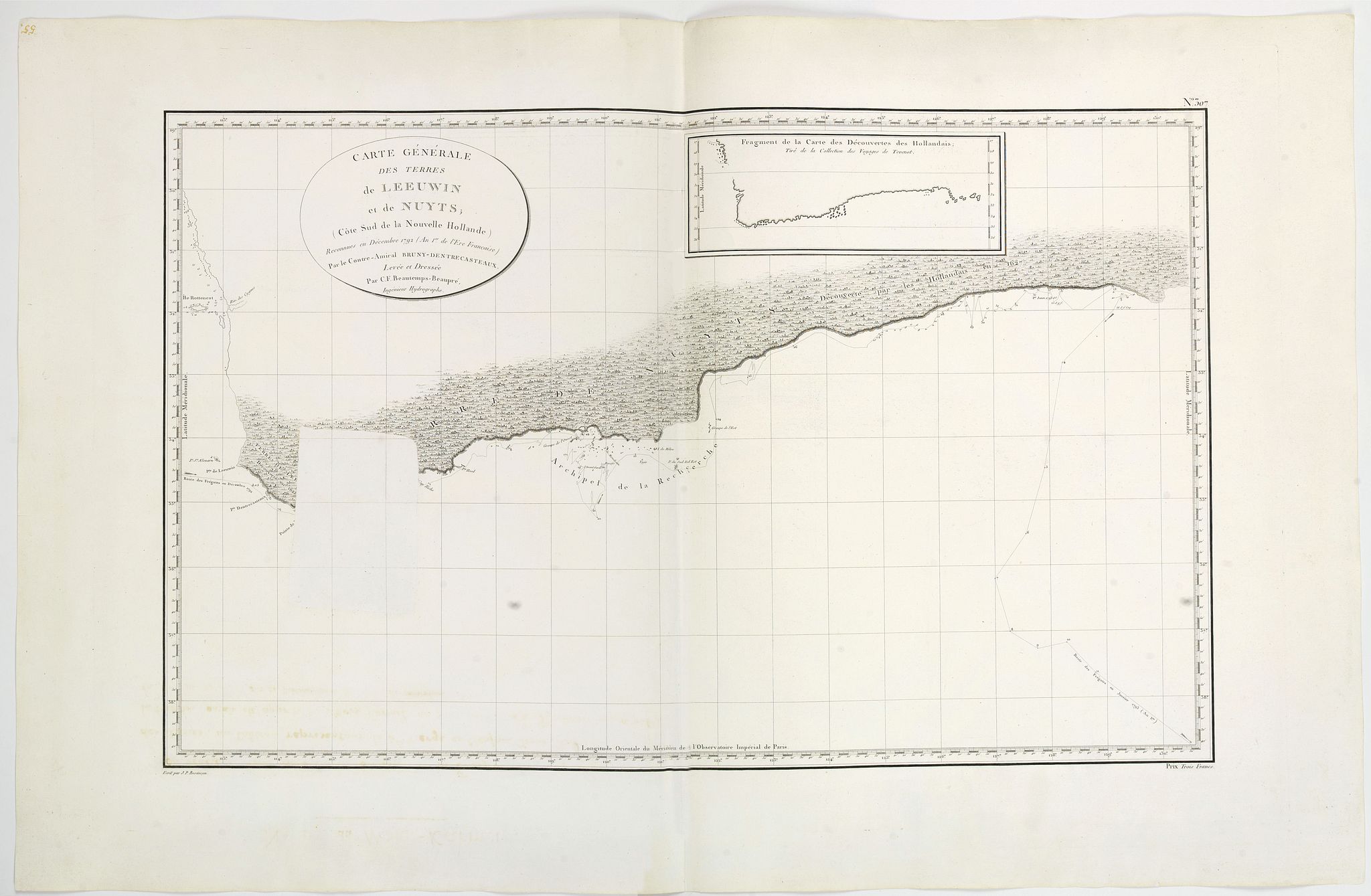
Carte Generale de Terres de Leeuwen et de Nuyts. . . |
||||||||||||||||||||
|
||||||||||||||||||||
|
|
||||||||||||||||||||
Estimated value: $1000 - $1000 |
||||||||||||||||||||
Description
'Terre de Nuyts' is the name formerly given in French to a coastal region of Australia, while the latter was still called New Holland. Roughly from the Leeuwin Land to the west and by the Napoleon Land to the east.
It occupied the southern shores of present-day Western Australia and the most westerly shores of South Australia.
This is the edition of the extremely rare atlas "Neptune des côtes orientales et du grand archipel d'Asie", published in 1807. The atlas was a supplement to the atlas series published by Hydrographic office and prepared by C.F Beautemps-Beaupré, who is now regarded as the father of modern French hydrography. The maps for the Neptune edition are printed on very thick and larger paper. The usual text in upper right corner is not there and but instead, "N°. 307" is engraved, and instead of Bouclet's name, the words "Prix Deux Francs" are in the bottom. Very rare.
Joseph Antoine Bruny-d'Entrecasteaux was born at Aix in Provence in 1739 and died at sea in 1793. He entered the marine service at the age of 15, and soon won praise for his work as a hydrographer. He became governor of the islands of Mauritius and Bourbon.
Beautemps-Beaupré is regarded as the father of modern hydrography.
He was a Knight of Saint-Louis, Knight of Saint Michel, Grand Officer of the Legion of Honor, he died in 1854, at the age of 88 years. He left to his companions the memory of a simple man, modest, judicious, courageous and good. Leading the way in the work, and training his engineers, Beautemps-Beaupré has earned the title of father of hydrography that has been awarded.
More about "mapping of Australia." and Beautemps-Beaupré [+]
Reference: Tooley, R.V. The Mapping of Australia and Antarctica, pg 73. ref 550 5not mentionining this state)
FAQ - Guarantee - Shipping
Buying in the BuyNow Gallery
This item is available for immediate purchase when a "Add to Cart" or "Inquire Now" button is shown.
Items are sold in the EU margin scheme
Payments are accepted in Euros or US Dollars.
Authenticity Guarantee
 We provide professional descriptions, condition report and HiBCoR rating (based on 45 years experience in the map business)
We fully guarantee the authenticity of items we sell. We provide a certificate of authenticity for each purchased item.
Condition / Coloring
We indicate the condition of each item and use our unnique HiBCoR grading system in which four key items determine a map's value: Historical Importance, Beauty, Condition/Coloring and Rarity.
We offer many maps in their original black and white condition. We do not systematically color-up maps to make them more sellable to the general public or buyer.
Copper engraved or wood block maps are always hand colored. Maps were initially colored for aesthetic reasons and to improve readability. Nowadays, it is becoming a challenge to find maps in their original colors and are therefor more valuable.
We use the following color keys in our catalog:
Original colors; mean that the colors have been applied around the time the map was issued.
Colored; If the colors are applied recently or at the end of the 20th century, then "colored", or "attractive colors" will be used.
Original o/l colors; means the map has only the borders colored at the time of publication.
Read more about coloring of maps [+]
FAQ
Please have a look for more information about buying in the BuyNow gallery.
Many answers are likely to find in the general help section.
Virtual Collection
![]()
With Virtual Collection you can collect all your favorite items in one place. It is free, and anyone can create his or her Virtual map collection.
Unless you are logged in, the item is only saved for this session. You have to be registed and logged-in if you want to save this item permanently to your Virtual Collection.
Read More [+]
Registering Here, it is and you do not need a credit card.
Add this item to
Virtual Collection
or click the following link to see my Virtual Collection.
Invoice
The invoice and certificates of authenticity are available in the client center >Invoices
| High-Resolution Digital Image Download | |
|
Paulus Swaen maintains an archive of most of our high-resolution rare maps, prints, posters and medieval manuscript scans. We make them freely available for download and study. Read more about free image download |
Click this image for a free HR-image download. |
In accordance with the EU Consumer Rights Directive and habitually reside in the European Union you have the right to cancel the contract for the purchase of a lot, without giving any reason.
The cancellation period will expire 14 calendar days from the day after the date on which you or a third party (other than the carrier and indicated by you) acquires, physical possession of the lot. To exercise the right to cancel you must inform Paulus Swaen Europe bv, which is offering to sell the lot either as an agent for the seller or as the owner of the lot, of your decision to cancel this contract by a clear statement (e.g. a letter sent by post, or e-mail (amsterdam@swaen.com).
To meet the cancellation deadline, it is sufficient for you to send your communication concerning your exercise of the right to cancel before the cancellation period has expired.