Waghenaer, The Mariners Mirrour
Sold
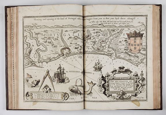
The extremely rare First English-language edition. [London: John Charlewood, 1588.] Two parts in one. Folio in 6s and 2s (15 2/8" x 10 1/2", 391mm x 266mm). Several charts in a probably 19th or earlier hand, with coloring. With an engraved frontispiece, engraved dedication, a small engraved radial plate tipped in to A1 and 3 engraved plates (with volvelles), plus 45 double-page engraved charts. The plates are engraved by De Bry, Jodocus Hondius, Augustine Ryther and Johannes Rutlinger. Bound in a contemporary brown calf, with raised spine, richly gilded, framed boards, and a beautiful golden central motif of a wreath of laurel branches.
Lucas Janszoon Waghenaer (1533-1606), one of the brightest lights of Dutch Golden-Age mapmaking, distinguished himself from many of his fellow stars by some 14 years of seafaring, rather than simply compiling the exploration and observation of others. The Mariner's Mirrour was translated from the 1586 Latin edition, Speculum Nauticum. The atlas, properly a rutter (seafarer's handbook) has charts.
For the first time an atlas integrated the first time charts, ships' logs and rutters (handbooks of voyages). As a result, the popularity of the work was extraordinary. (Despite the longstanding antipathy between the Low Countries and England, sea-atlases were long called "wagoners" after Waghenaer.) When a copy of the Spieghel was brought to a Privy Council meeting in 1585, it was noticed that a translated edition would be very useful indeed. That translation into Latin appeared in 1586, and it is from that edition that the Lord Chancellor, Sir Christopher Hatton, commissioned an English translation from Anthony Ashley, the Privy Council's clerk.
The atlas was published in October 1588 – the year of the Armada – and engraved by de Bry, Hondius, Rutlinger and Ryther, who also engraved some of Saxton's maps.
References.: Koeman, Atlantes Neerlandici, Vol. IV, Wag 13. Tony Campbell (ed.), “Chronicle for 1993” in Imago Mundi 46 (1994), 191-204; 203.
