Browse Listings in Europe > Russia / Baltic / Black Sea region > Ukraine / Black Sea
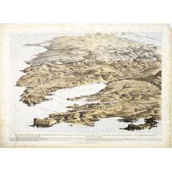
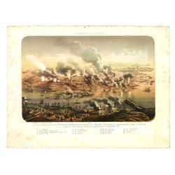
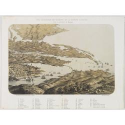
![A Panoramic View of the Position now occupied by the Allied Armies before Sebastopol [. . .] sketched by command of the Emperor Louis Napoleon by an eminent officer of the French Imperial Engineers](/uploads/cache/33753-250x250.jpg)
A Panoramic View of the Position now occupied by the Allied Armies before Sebastopol [. . .] sketched by command of the Emperor Louis Napoleon by an eminent officer of the French Imperial Engineers
A panoramic view of the position occupied by the Allied Armies before Sevastopol in Ukraine.Chromolithographed and designed by Thomas Parker, and published by Read & ...
Place & Date: London, 1855
Selling price: $250
Sold in 2013
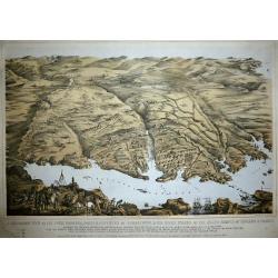
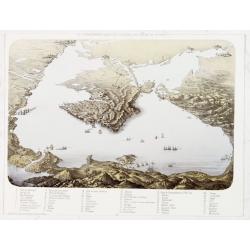
Panoramic view of the Present Extended Position of the Allied Armies of England, France, Turkey and Sardinia. - Panorama de la position presente des armées alliées, Anglaise, Française, Turque et Sarde. . .
Panoramic view of the position of the Allied Armies of England, France, Turkey and Sardinia at the south side of Sevastopol in Ukraine.Chromolithographed and designed by ...
Place & Date: London, 1855
Selling price: $250
Sold in 2013
A Panoramic View of the Town, Harbour, Forts & Defences of Sebastopol & The Siege Works of The Allied Armies of England & France.
Printed & Published April 18th 1855 by Stannard & Dixon 7, Poland St London. A large panoramic plan of the town, harbour, forts and defenses of Sevastopol in Ukra...
Place & Date: London, 1855
Selling price: $250
Sold in 2014
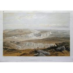
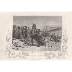
The ruins of Inkermann and city of caverns.
A spectacular view of the area of Inkerman in the Ukraine, now under Russian control (Crimean peninsula). Original colored lithograph by Day & Son. Published May 22nd...
Place & Date: London, 1855
Selling price: $40
Sold in 2015
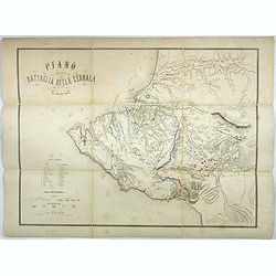
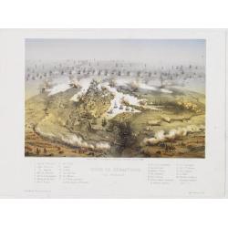
Plano della battaglia della Cernaia.
Large lithographed map showing the Battle of the Chernaya. Decorative title with numbered key (1-17) and a color key indicating the French, English, Italian, Turkish and ...
Place & Date: Milan, 1855
Selling price: $200
Sold in 2017
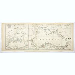
Ponti Euxini Periplus secundum Arrianum.
Two ancient maps on one sheet showing the Black Sea and Ukraine, prepared by Karl Wilhelm Ludwig Muller (1813-1894) and published in "Geographi Graeci Minores"....
Place & Date: Paris, Ambrosio Firmin Didot, 1855
Selling price: $20
Sold in 2017
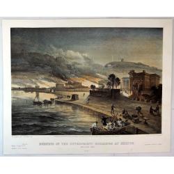
Burning of the Government buildings at Kertch.
A fine hand colored lithograph from "THE SEAT OF WAR IN THE EAST". By the illustrator William Simpson (1823-1899). Published in London in 1855 by Paul and Domin...
Place & Date: London, 1855
Selling price: $15
Sold in 2018
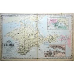
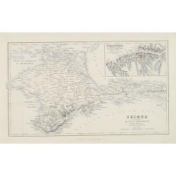
A Complete Map of the Crimea, Showing the Miliray and Carriage Roads...
A complete map of the Crimea, showing the military and carriage roads...
Place & Date: Pennsylvania, 1856
Selling price: $155
Sold in 2010
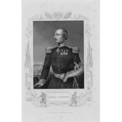
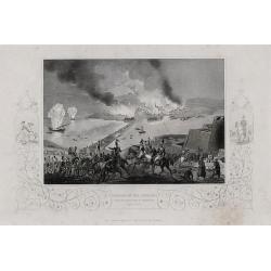
A complete set of 30 engravings depicting The Crimea war, the Battles between the Russian Empire and several European powers for influence over territories of the declining Ottoman Empire, Nicholas I. Emperor of Russia and the Military Leaders of the Euro
A complete set of 28 engravings depicting The Crimea war, the Battles between the Russian Empire and several European powers for influence over territories of the declini...
Place & Date: London, 1858
Selling price: $235
Sold in 2016
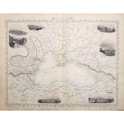
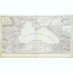
Black Sea.
A highly detailed and decorative map with six vignette illustrations. One of the John Tallis maps published around the time of the Crimea War by The London Printing and P...
Place & Date: London, 1858
Selling price: $65
Sold in 2016
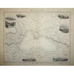
Black Sea
A highly detailed and decorative map of the Black Sea and surrounding areas. The map is enhanced by vignette illustrations of Sebastopol, Varna, Odessa, Sinope, Silistra...
Place & Date: London, 1858
Selling price: $70
Sold in 2017
A set of 18 engravings ‘The Crimea War' the Battles between the Russian Empire and the European powers for influence over territories of the declining Ottoman Empire, Nicholas I. Emperor of Russia and the Military Leaders of the European powers.
A collection of 18 steel engravings, depicting The Crimea war, those Battles between the Russian Empire and several European powers for influence over territories of the ...
Place & Date: London, 1858
Selling price: $140
Sold in 2016
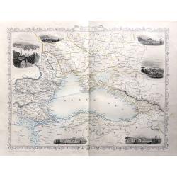
Black Sea
A map of the Black Sea and the surrounding lands, including Turkey, Russia, Georgia, Azerbaijan, Bulgaria, Crimea and Armenia, with six decorative vignettes views of Seba...
Place & Date: London, 1858
Selling price: $65
Sold in 2018
A SET OF 20 engravings depicting The Crimea war, the Battles between the Russian Empire and several European powers for influence over territories of the declining Ottoman Empire, Nicholas I. Emperor of Russia and Military Leaders of the European Powers
An interesting set of 20 engravings depicting The Crimea war, the Battles between the Russian Empire and several European powers for influence over territories of the dec...
Place & Date: London, London Printing & Publishing Company, 1858
Selling price: $100
Sold in 2020
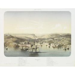
MER NOIRE Sébastopol. 61.
Beautiful and rare lithography of the port of Sevastopol at the Black Sea the Crimea peninsula. Extensive shipping in the harbor. With a numbered key (1-22) in lower part...
Place & Date: Paris, Lemercier, c.1860
Selling price: $250
Sold in 2010
MER D'AZOF. Bombardement d'arabat par la flotille alliée 25 Mai 1855.
Beautiful and rare lithography of two French boats, "Le Lucifer" and "La Miranda" during the siege of Arabat in 1855.
Place & Date: Paris, Lemercier, c.1860
Selling price: $250
Sold in 2010
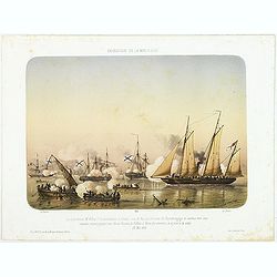
AFFAIRES D'ORIENT Attaque et reddition du fort de Kilburn par les flottes alliées, 17 octobre 1855.
Beautiful engraving of the siege of Kilburn on 17 October 1855 by the French navy. After a design Louis by Le Breton. including a numbered key (1-4) in the lower part.Lou...
Place & Date: Paris, Lemercier, c.1860
Selling price: $250
Sold in 2010
Crimea according to Huot & Demidoff.
Detailed map probably from, A Gazetteer of the World, Or Dictionary of Geographical Knowledge, Compiled from the Most Recent Authorities, and Forming a Complete Body of M...
Place & Date: Edinburg, London, Fullarton, 1860
Selling price: $50
Sold in 2010
Sébastopol vue du Nord. - Les divisions françaises aux ordres des généraux Bosquet et Mac Mahon prennent d'assaut la tour Malakoff. . , (le 8 septembre 1855). Crimée (Ukraine)
Lithography of the siege of Sebastopol on 8 September 1855 who resulted in a French victory under General MacMahon. In one of the Crimean War defining moments, the French...
Place & Date: Paris, Lemercier, c.1860
Selling price: $220
Sold in 2010
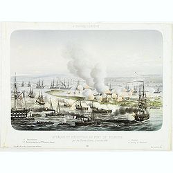
AFFAIRES D'ORIENT Attaque et reddition du fort de Kilburn par les flottes alliées, 17 octobre 1855.
Beautiful lithography of the siege of Kilburn on 17 October 1855 by the French navy. After a design Louis by Le Breton. including a numbered key (1-4) in lower part.Louis...
Place & Date: Paris, Lemercier, c.1860
Selling price: $250
Sold in 2014
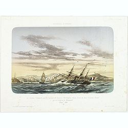
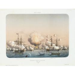
AFFAIRES D'ORIENT Le Vauban, Commandé par le Captaine de Vaisseau d'Herbinghem, chasse devant lui deux Croiseurs Russes qui se réfugient à Sévastopol. Mars 1854.
Beautiful lithography of the French steamer "Le Vaunan", commanded by Captain de Poucques d'Herbingheme, chasing two Russian Vessels seeking safe-harbour in Sev...
Place & Date: Paris, Lemercier, c.1860
Selling price: $400
Sold in 2013
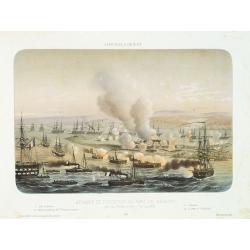
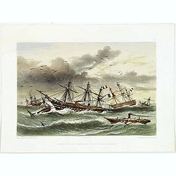
EXPEDITION DE LA MER D'AZOF Le Lieutenant M.Killop Captain la canonniére le Snake, sous le feu des batteries de Kertch. . . 22 Mai 1855.
Beautiful lithography of an encounter which took place on 22 May 1855 between Lieutenant M'Killop, who was the commander of a gunboat, the Snake, with 3 Russian vessels, ...
Place & Date: Paris, Lemercier, c.1860
Selling price: $250
Sold in 2014
Ouragan du 14 dans la Mere Noir vis à vis la Baie de Kamiesh.
Beautiful lithography of French ships in Kamiesch Bay in the Black Sea near Sebastopol on the Crimean coast. During the siege of Sebastopol in 1854 during the Crimean War...
Place & Date: Paris, Lemercier, c.1860
Selling price: $250
Sold in 2014

Le descartes devant Sébastopol.
Beautiful lithography of the French steamer Le Descartes offshore of Sevastopol.After a design by Louis Le Breton (1818 Douarnenez - 1866 Paris). Louis Le Breton was a Fr...
Place & Date: Paris, Langlumé, c.1860
Selling price: $250
Sold in 2014
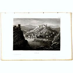
Tiflis.
View of Tiflis. Original steel engraving, published by Bibliographisches Institut Hildburghausen.
Place & Date: Hildburghausen, ca. 1860
Selling price: $10
Sold in 2020
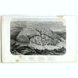
Plan of Attack & Defences of the South & North Sides of Harbour & Town of Sebastopol.
Scene during Crimean (Russo-Turkish) War 1853-1856. Bird's-eye plan of the harbour and town of Sebastopol Sevastopol) with the retreat of the Russians. Steel engraved pla...
Place & Date: London, James S Virtue, 1860
Selling price: $50
Sold in 2017
Vue générale du théatre de la guerre d'Orient dans la province de Kerson.
Panoramic View of Nicolaieff and Kerson Bay in the Ukraine. Including a numbered key (1-46) in lower part, mentioning all place names.Published by Wild, rue de la Banque ...
Place & Date: Paris, Wild, c.1865
Selling price: $240
Sold in 2010
Vue panoramique du litoral de la Mer Noir.
Panoramic view of the Black Sea with a key 1-53 in lower margin, mentioning all place names.Published by Wild, rue de la Banque 15 près la Bourse, in Paris.
Place & Date: Paris, Wild, c.1865
Selling price: $200
Sold in 2013
Siège de Sébastopol Vue générale. 2
Panoramic town-plan of the siege of Sebastopol. Chromolithograph after A Cassagne and V. Adam, printed by Lemercier. With a key 1-24 in lower margin.
Place & Date: Paris, Morier, c.1865
Selling price: $200
Sold in 2013
Carte de la Russie d'Europe et de la Turquie Théàtre de la Guerre en Oriens. . .
Very large, highly detailed and uncommon issue of the map by Brué depicting the progress of the war in the Ukraine, the Crimea and the Black Sea. Including Istanbul and ...
Place & Date: Paris, London, ca. 1867
Selling price: $400
Sold in 2013
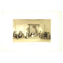
Danse Kalmouke sous la tente de la Princesse Tumêne.
Lithography from a rare book by Hommaire-de-Hell "Voyage à la mer Caspienne". Ignace-Xavier Morand Hommaire-de-Hell (1812-1848) was a traveler and geologist, w...
Place & Date: Paris, Lemercier, 1868
Selling price: $50
Sold in 2010
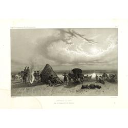
Campement de nuit dans les steppes de la mer Caspienne. Voyage à la mer Caspienne par Mr et Mme Hommaire de Hell.
Lithography after a design by Gluck of a Kalmouk Buddhist Temple in the Republic of Kalmykia, the only Buddhist region in Europe. Lithography taken from "Voyage à l...
Place & Date: Paris, Lemercier, 1868
Selling price: $50
Sold in 2011
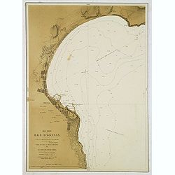
Mer Noire - Baie d'Odessa. . .
Detailed chart of the Bay and town of Odessa in the Ukraine. With soundings. According to the title the chart is copied from a Russian map made by Lieut. Belgavski. The c...
Place & Date: Paris, 1869
Selling price: $120
Sold in 2012
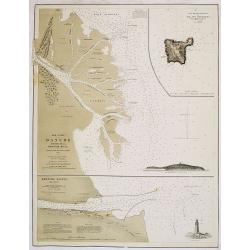
Mer Noire. Danube Bouches de la Branche Kilia. / Branche Sulina (Danube).
Two very detailed charts of the outlet of the Danube River into the black Sea. In upper right corner inset map of "Ilan Ada st ou Fido-Nisi ou Ile aux serpents. . . ...
Place & Date: Paris, after 1869
Selling price: $150
Sold
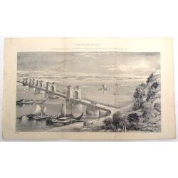
Suspension Bridge, Russia, Across the Dnieper at Kieff.
Fine lithograph of the wrought iron bar-chain suspension bridge erected by command of the Emperor of Russia. Currently, the bridge is in Kiev, Ukraine.
Place & Date: 1870
Selling price: $89
Sold in 2015
![Karta Kievskoi Gubernii [Kiev Governorate, Ukraine].](/uploads/cache/34757-250x250.jpg)
Karta Kievskoi Gubernii [Kiev Governorate, Ukraine].
A detailed map of Ukraine's Kyiv Governorate, printed in St. Petersburg by Alexey Afinogenovich Ilyin, one of the most important 19th Century maps of the region.This fine...
Place & Date: St. Petersburg, 1871
Selling price: $750
Sold in 2021
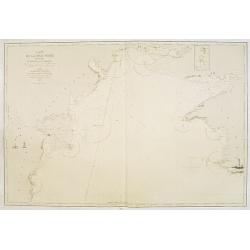
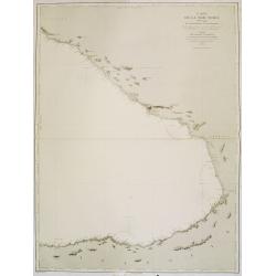
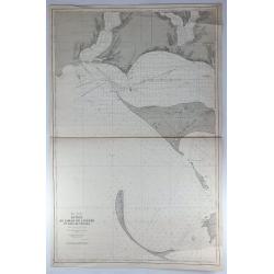
Carte de la Mer Noire. (3e Feuille). Du Cap Chersonèse à la pointe Chardak.
Very detailed chart of the Black Sea with the entry to the Sea of Azof. including the towns of Kerch, Sevastopol, etc. Showing soundings in meters, lighthouses are marked...
Place & Date: Paris, 1860 updated to 1874
Selling price: $200
Sold in 2012
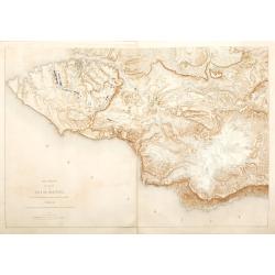
Carte de la Mer Noire. (2e Feuille). De Mangalia au Cap Chersonèse.
Very detailed chart of the Black Sea including the towns of Odessa, Sevastopol, etc. In the upper right corner small inset map of the Dniprov River up to Nikolaef. Showin...
Place & Date: Paris, 1860 updated for 1874
Selling price: $210
Sold in 2012
Plan général des environs de Sébastopol avec indication de la disposition générale de l'armée alliée au 24 octobre / 5 novembre 1854 et du mouvement du prince Gortchakow vers le mont Sapoune.
A very rare panoramic town-plan of the siege of Sebastopol. In lower margin : "Gravé au Dépôt topographique de la Guerre". From "Défense de Sébastopol...
Place & Date: Saint-Pétersbourg / Paris, 1863-1874
Selling price: $750
Sold in 2014
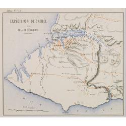
Expédition de Crimée. 1854 Plan de Sébastopol.
Map of Krim area centered on Sebastopol and showing in red the French expedition of 1854. Published in \"Atlas de Géographie Militaire adopté par M. le min. de la ...
Place & Date: Paris, Furne, Jouvet et Cie, 1875
Selling price: $50
Sold in 2009
Carte de la Mer Noire. (4e Feuille). Du Cap Idokopas au Cap Zefiros.
Very detailed chart of the eastern part of the Black Sea with the coast of Georgia, including the towns of Lidzava, Anaklia, Poti, Supsa, Kobuleti. Showing soundings in m...
Place & Date: Paris, 1860 updated to 1875
Selling price: $300
Sold in 2013
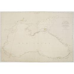
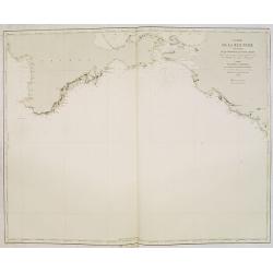
Carte générale de la Mer Noire Dressée d'après les travaux russes . . .
Chart of the Black Sea, with latitude and longitude scales, villages, banks and soundings in fathoms. Lighthouses highlighted in yellow and red.A line in red pen and ink ...
Place & Date: Paris, 1860 with updates for 1868 - 1876
Selling price: $300
Sold in 2011
Schwarzes Meer Nr 1
Uncommon map of the Black Sea and Crimea. In lower part a scale. Prepared by F.Handtke
Place & Date: Glogau, Leipzig, 1877
Selling price: $120
Sold in 2011
Japanese map of Central part of Europe with Black Sea and Ukraine.
Japanese map of Central part of Europe with Black Sea and Ukraine, with a description to the right.
Place & Date: Japan, ca. 1880
Selling price: $200
Sold in 2012
Mer Noire - Entrée du Liman du Dnieper et Baie de Tendra.
A fine large sea chart on the Black Sea in the Ukraine featuring the Dnieper River and the Tendra Bay. It has an insert of Liman de Berezan and shows Kinburn Spit and Ca...
Place & Date: Paris, 1887
Selling price: $17
Sold in 2018
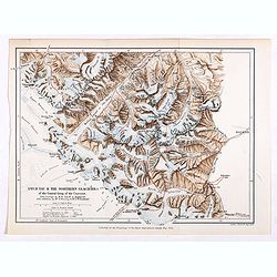
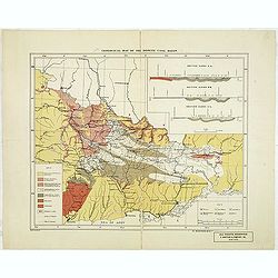
Dych-Tau & the Northern Glaciers of the Central Group of the Caucasus from surveys by M.M.Jukoff & Bogdanoff. . .
Early map of Dykh-Tau or Dykhtau, from surveys by M.M.Jukoff & Bogdanoff. Dykh-Tau is a mountain located in Kabardino-Balkaria, Russia, its peak stands about 5 km (3 ...
Place & Date: London, Edward Stanford, 1890
Selling price: $50
Sold in 2019
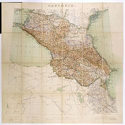
Caucasia.
Original hand-colored zincograph map of the Caucasus located at the border of Europe and Asia. The map shows part of the Black Sea and the Caspian Sea. The map is on a sc...
Place & Date: London, 1906
Selling price: $310
Sold in 2017
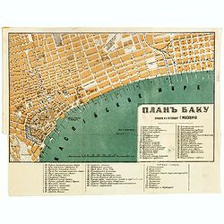
Baku (Баку, Bakı) city map, 1912
color lithographed plan of Baku (Baki) in Azerbaijan by A.Yakovenko, a publisher active in in Saint Petersburg. Scales in Russian sazhens and British inches and two numbe...
Place & Date: Saint Petersburg, 1912
Selling price: $100
Sold in 2017
Geological map of the Donetz coal basin.
Uncommon American geological map of the Russian Donetz coal zone, published by R. Martens & Co. From New York. color key in lower left corner. The coal-field was disc...
Place & Date: New-York, ca. 1916
Selling price: $200
Sold in 2013
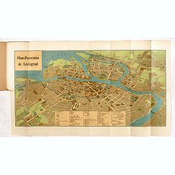
Plan-Panorama de Léningrad.
Official Intourist booklet with a panoramic plan of St. Petersburg printed in chromo-lithography, folded and kept in beige wrapper with title "PLAN-PANORAMA DE LENIN...
Place & Date: Russia, 1931-1934
Selling price: $200
Sold in 2014
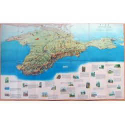
MAP OF CRIMEA
Large illustrated tourist-map of Crimea, with a beautiful representation of the topographic features of the peninsula. Published by the Office of Geodesy and Cartography ...
Place & Date: Moscow, 1963
Selling price: $22
Sold in 2012
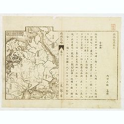
![[RUSSIAN MAP] Battle of Stavuchany 1739.](/uploads/cache/85306-250x250.jpg)
[RUSSIAN MAP] Battle of Stavuchany 1739.
An extremely rare, large Russian single sheet map, of the plan of the battle of Stavuchany. Printed in Russian and German languages, possibly by the Academy of St.Petersb...
Place & Date: St.Petersburg, ca 1739
Selling price: $1500
Sold in 2021
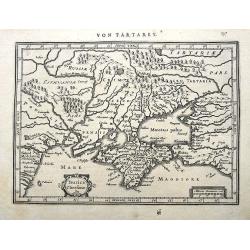
Taurica Chersonesus.
A copper engraved map of the central Ukraine from the "Atlas Minor" (Gerhard Mercator / Jodocus Hondius). Extends from Cherkassy to Crimea and the Sea of Azov. ...
Place & Date: Amsterdam, ca. 1609 -1660
Selling price: $47
Sold in 2018