Browse Listings in Europe > British Isles > British Counties
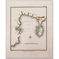
Gibraltar Bay.
A striking map of Gibraltar and Gibraltar Bay with Old Gibraltar across the bay by T. Walsh, and engraved by S. Neele.From “Journal of the Late Campaign in Egypt: Inclu...
Place & Date: London, 1803
Selling price: $31
Sold in 2017
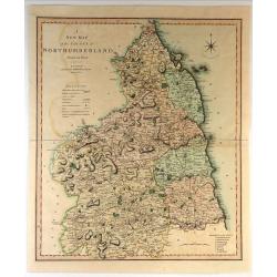
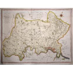
A New Map of the County of Northumberland Divided into Wards.
Handsome and detailed county map shows market towns with distances from London in measured miles. The major canals, roads, railways, parks and churches are also clearly m...
Place & Date: London, 1804
Selling price: $31
Sold in 2018
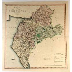
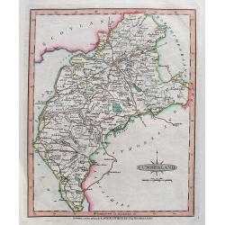
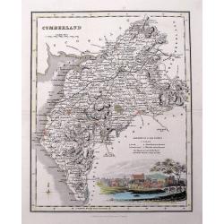
A New Map of the County of Cumberland
Handsome and detailed county map shows market towns with distances from London in measured miles. The major canals, roads, railways, parks and churches are also clearly m...
Place & Date: London, 1804
Selling price: $15
Sold in 2017
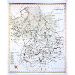
Cambridgeshire from the Best Authorities.
Detailed map of Cambridgeshire published by John Stockdale in Piccadilly. Nice presentation of roads mountains and rivers. It features the cities of Cambridge, Caxton, El...
Place & Date: London, 1805
Selling price: $16
Sold in 2016
A MAP OF MIDDLESEX FROM THE BEST AUTHORITIES 1805
A detailed copper engraved map of the county of Middlesex by John Cary. The map was produced to accompany Richard Gough’s new edition of Camden’s Britannia and publis...
Place & Date: London, 1805
Selling price: $100
Sold in 2017
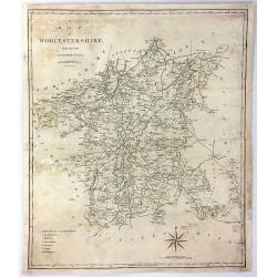
A Map of Worcester from the Best Authorities
A detailed and large map of Worcester, engraved by John Cary, for publication in Richard Gough's translation of William Camden's 'Britannia' in 1789. This edition was pu...
Place & Date: London, 1805
Selling price: $17
Sold in 2017
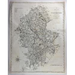
A Map of Staffordshire from the Best Authorities.
An attractive and detailed late 18th century map of Staffordshire, engraved by John Cary and published by Stockdale in Richard Gough's new translation of Camden's Britann...
Place & Date: London, March 1805
Selling price: $17
Sold in 2018
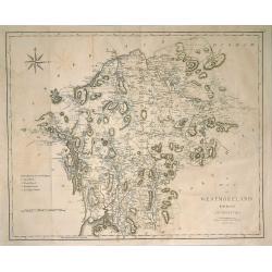
Map of Westmorland from the Best Authorities.
A finely engraved, highly detailed map by Cary, showing Ullswater, Windermere, etc. From Camden's 'Britannia' in 1789. John Cary (1754-1835) was an English cartographer, ...
Place & Date: London, 1805
Selling price: $20
Sold in 2019
Cumberland.
A detailed map of the area with many towns and villages named, connected by roads. Shows also hills, lakes, and rivers.Includes the "Picts Wall" near Carlisle.
Place & Date: London, 1806
Selling price: $50
Sold in 2018
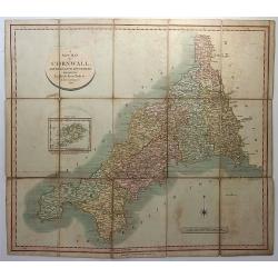
A New Map of Cornwall, Divided into Hundreds Exhibiting Roads, Rivers, Parks &c.
A superbly engraved map of the county of Cornwall by John Cary. From Cary's New English Atlas. The map was mounted on linen, folded and sold in a 7” x 4 ¾” x 3/8” ...
Place & Date: London, 1806
Selling price: $39
Sold in 2018
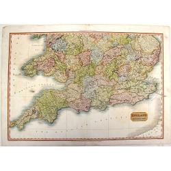
England, Southern Part.
A fine, detailed map of southern England and the English Channel. John Pinkerton (1758 – 1826) was a Scottish antiquarian, cartographer and historian. Pinkerton was a...
Place & Date: London, 1811
Selling price: $16
Sold in 2015
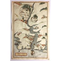
Fowey Haven & C., From a Chart Drawn in the Reign of K. Hen. VIII.
Plan of Fowey Haven. Published by Daniel & Samuel Lysons in 1814. It features views in almost a cartoon style of villages, from a chart of Cornwall, produced during t...
Place & Date: London, 1814
Selling price: $80
Sold in 2017
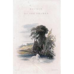
Set of 8 views from 'Source of the Thames'
Lovely set of seven highly attractive engraved views and the titlepage, by Cooke from his "Source of the Thames". The very decorative views, include much detail...
Place & Date: London, 1819
Selling price: $65
Sold in 2011
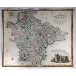
Map of the County of Devon, from an Actual Survey, Made in the Years 1825 & 1826
A very large map of the County of Devon by Christopher Greenwood, published by Greenwood & Co. It has an inset views of Exeter Cathedral and Lundy Island. The brother...
Place & Date: London, 1829
Selling price: $26
Sold in 2016
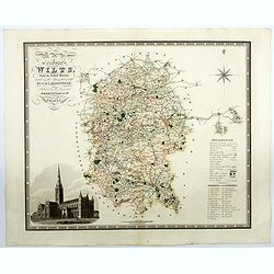
Map of the County of Wilts from an actual survey in the years 1919 & 1820. . .
A superb large scale map of the county of Wiltshire published by the Greenwood brothers. The brothers were surveyors and publishers and undertook the survey of most of th...
Place & Date: London, 1829
Selling price: $100
Sold in 2021
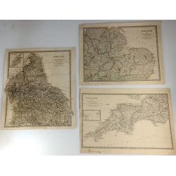
Three S.D.U.K. Maps - England I, England III & England IV
Three detailed maps of England by S.D.U.K. published in London in 1830 by Chapman & Hall and engraved by John Walker. “England I” covers Northumberland, Cumberla...
Place & Date: London, 1830
Selling price: $7
Sold in 2016
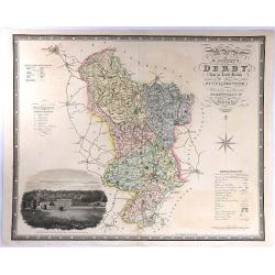
Map of the County of Derby, from an Actual Survey made in the Years 1824 & 1825. By C. & I. Greenwood.
A large map with decorative title at upper right, and a large vignette view of Chatsworth House at lower left. Published by Greenwood & Co. in London in 1830. Engrav...
Place & Date: London, 1830
Selling price: $20
Sold in 2016
![England [sheet IV].](/uploads/cache/44907-250x250.jpg)
England [sheet IV].
A single sheet (4) from a larger set of maps comprising England & Wales, produced for the Society for the Diffusion of Useful Knowledge (S.D.U.K.) in London in 1830. ...
Place & Date: London, 1830
Selling price: $20
Sold in 2020
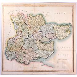
ESSEX
A large steel engraved map labelled "Essex", engraved by James Bingley, published in Virtue's “Picturesque Beauties of Great Britain” in London in 1834.
Place & Date: London, 1834
Selling price: $17
Sold in 2016
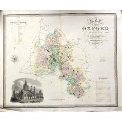
Map of the County of OXFORD from an Actual Survey' by C. & J. Greenwood.
A very attractive and detailed 19th century map of Oxfordshire, replete with a fine vignette view of Oxford Cathedral, which was published in Christopher and John Greenwo...
Place & Date: London, 1834
Selling price: $135
Sold in 2018
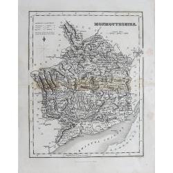
(Lot of 2 maps) Wales - Monmouthsthire
An interesting pair of old maps of Wales: - Fullarton, ca. 1835, "Monmouthshire". 240 x 190 mm. A detailed map with much information, showing also the distance...
Place & Date: England, c1835
Selling price: $1
Sold in 2012
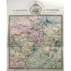
A new & improved map of the environs of Windsor, extending from 14 to 18 miles round the castle.
An apparently very scarce map (Copac with only 2 listings) of the area around Windsor. The map includes roads and distances. The title with a decorative vignette. Drawn ...
Place & Date: London, ca. 1835
Selling price: $210
Sold in 2023
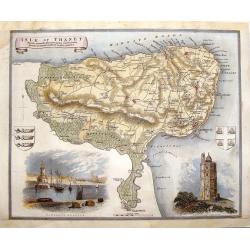
Isle of Thanet.
Decorative map oF the Island of Thanet, Kent with two views and 2 coats of arms. This is a map from "ENGLISH COUNTIES DELINEATED" by Thomas Moule who combined a...
Place & Date: London, 1838
Selling price: $48
Sold in 2014
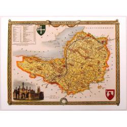
Somersetshire.
Nice hand-colored map of Somersetshire with a fine engraving cartouche of Glastonbury Cross. It also has two coats of arms. Thomas Moule (1784 - January 1851) was an Eng...
Place & Date: London, 1840
Selling price: $4
Sold in 2013
Cumberland.
Highly detailed map of the county, with a nice view of Carlisle shown from the North East. The map shows towns and villages, streets, lakes, rivers, forests, hills, etc. ...
Place & Date: Glasgow, c1840
Selling price: $1
Sold in 2016
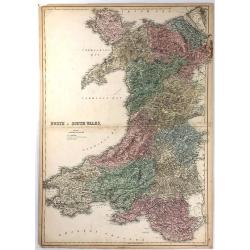
North & South Wales.
This large map is of NORTH & SOUTH WALES. The map is from the 1856 edition of Black's “General Atlas of the World”. The map displays the provinces (of that time) ...
Place & Date: Edinburgh, 1856
Selling price: $15
Sold in 2016
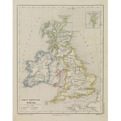
Groot-Brittanje en Ierland.
Uncommon map of England, Ireland and Wales, Scotland. Inset of Shetland islands. Lithography by J.H. van Weijer, published in Atlas der geheele Aarde [?] in 24 kaarten.
Place & Date: Groningen, ca. 1860
Selling price: $20
Sold in 2008
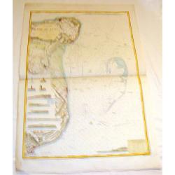
Angleterre Cote S.E., Rade des Dunes.
Informative sea chart featuring the coast of England from Margate to Dover with miniatrure city plans of Deal and Ramsgate in between. Miniature colored pictures of ligh...
Place & Date: Paris, 1866
Selling price: $99
Sold in 2015
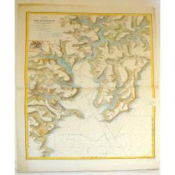
Angleterre Cote Sud, Port du Falmouth.
Striking lithographed sea chart of the Port of Falmouth in England. Depôt des Cartes et Plans de la Marine (1720 - present), often called the Depôt de Marine, was a Fr...
Place & Date: Paris, 1870
Selling price: $79
Sold in 2015
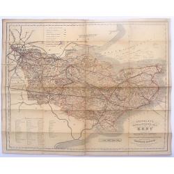
Cruchley's Road and Railway Maps of the County of Kent.
Interesting map featuring the roads and rail lines in the English county of Kent. It also shows the names of the stations, turnpike roads, villages, gentlemen's seats, im...
Place & Date: London, 1888
Selling price: $15
Sold in 2016
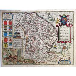
The Countie and Citie of Lyncolne described with the Armes of Them That Have Bene Earles thereoe since the conquest.
“The Countie and Citie of Lyncolne described with the Armes of Them That Have Bene Earles thereoe since the conquest”. English county map by John Speed. The plates we...
Place & Date: London, 1614
Selling price: $450
Sold in 2020
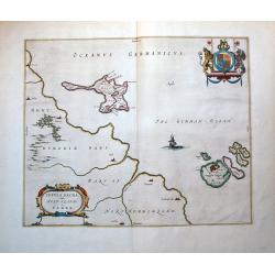
Insula Sacra; Vulgo Holy Iland; Et Farne.
Attractive map of Holy and Farne Islands off the coast of Northumberland. Farne Island is shown with the Tower and on Holy Island a fort and abbey are visible. The mainla...
Place & Date: Amsterdam, 1646.
Selling price: $180
Sold in 2012
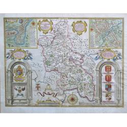
Buckinghamshire.
An attractive map of Buckinghamshire from the "Theatre of Great Britaine" by John Speed, published by Thomas Bassett and Richard Chiswell with two interesting i...
Place & Date: London, 1676
Selling price: $450
Sold in 2020
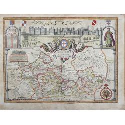
BARKSHIRE DESCRIBED.
Original copperplate engraved map printed on handmade paper, with original hand coloring. A spectacular pictorial of WINDSOR CASTLE across the top of this decorative map....
Place & Date: London, 1710
Selling price: $400
Sold in 2013