Search Listings matching "ukraine" in Europe > Russia / Baltic / Black Sea region
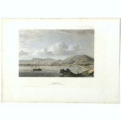
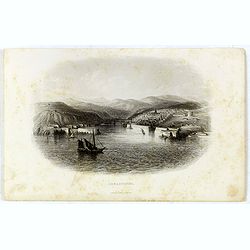
Kertsch im südlichen Russland. (Kerch)
Steel engraving with a panoramic view of the town of Krech, published in "Meyers Universum oder Abbildung und Beschreibung des Sehenswerthesten und Merkwürdigsten d...
- $15 / ≈ €14
Place & Date: Hildburghausen, 1848
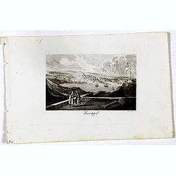
Sewastopol. (Sebastopol)
View of Sebastopol. Engraved by Leopold Zechmayer who was active in Vienna.
- $20 / ≈ €19
Place & Date: Vienna, ca. 1835
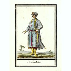
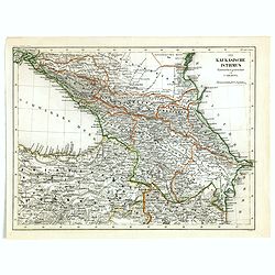
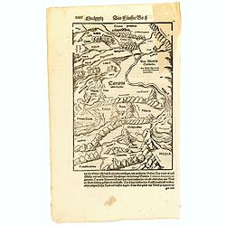
Kabardinien.
Originally hand-colored costume mezzotint of a Kabardian from the Northwest Caucasus, engraved by Félix Mixelle and Lachaussée Jeune after Jacques Grasset de Saint-Sauv...
Place & Date: Paris,1801-1806
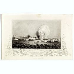
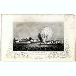
Bombardment of Odessa by the English and French April 22 1854, explosion on the imperial mole . . .
Scene from the Crimea war, showing a bombardment of Odessa, 22nd April 1854 (during Crimean War, 1853-56), by English and French forces, explosion imperial mole (breakwat...
- $30 / ≈ €28
Place & Date: London, ca. 1879

Femme Tartare d'Usbec.
Originally hand-colored costume mezzotint of a woman from Uzbekistan engraved by Félix Mixelle and Lachaussée Jeune after Jacques Grasset de Saint-Sauveur.As an etcher,...
Place & Date: Paris,1801-1806
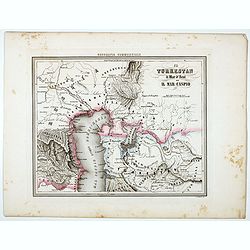
Il Turkestan il Mar d'Aral ed il Mar Caspio.
Uncommon map of Turkestan with the Northern part of the Caspian Sea, prepared by Francesco Costantino Marmocchi. Above the map "Geografia Commerciale". From &qu...
Place & Date: Genova, Paolo Rivara fu Giacomo, 1858
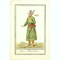
Homme Tartare d'Usbec.
Originally hand-colored costume mezzotint of a man from Uzbekistan engraved by Félix Mixelle and Lachaussée Jeune after Jacques Grasset de Saint-Sauveur.As an etcher, d...
Place & Date: Paris,1801-1806
Bombardment of Odessa by the English and French April 22 1854, explosion on the imperial mole . . .
Scene from the Crimea war, showing a bombardment of Odessa, 22nd April 1854 (during Crimean War, 1853-56), by English and French forces, explosion imperial mole (breakwat...
- $30 / ≈ €28
Place & Date: London, 1855
![[Calmucchi].](/uploads/cache/34988-250x250.jpg)
[Calmucchi].
Aquatint costume plate of the Kalmyk people. The name is given to the Oirats in Russia, whose ancestors migrated from Dzungaria in 1607. They created the Kalmyk Khanate i...
- $50 / ≈ €47
Place & Date: Milan, 1827
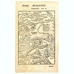
Der Kaukasische Istmus . . .
Detailed contemporary colored map of the countries of the Caucasus Mountains. Steel engraving appeared in "Meyer's Lexicon. Atlas der Geographie". Engraved by C...
- $45 / ≈ €42
Place & Date: Hildburghausen, 1849
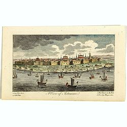
A View of Astracan. (Astrakhan)
A striking and highly detailed copper engraved panoramic view of Astrakhan, Russia, with its buildings, churches and town wall. The River Volga in the foreground. Several...
- $50 / ≈ €47
Place & Date: London, 1820
Sebastopol.
Steel engraving of the harbour at Sebastopol in the Ukraine published by James Virtue around 1860.
- $45 / ≈ €42
Place & Date: London, 1860
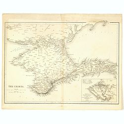
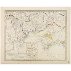
The Crimea.
Map of Crimea and the Sea of Azov. In lower right corner inset map showing Sebastopol region.
- $50 / ≈ €47
Place & Date: London, 1854
![[Costumes des Karabulaks - Caucase]](/uploads/cache/62344-250x250.jpg)
[Costumes des Karabulaks - Caucase]
Four men from the Caucasus in typical dress from the Karabulaks tribe. Plate N° 15. from Giulio Ferrario's work "Le Costume Ancien et Moderne ou Histoire du gouvern...
Place & Date: Milan, 1827
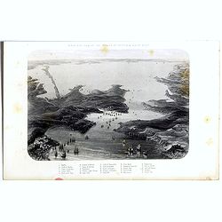
Birds-eye view of the Straits of Kertch & Sea of Azoff.
Steel engraving of the harbour at Sebastopol and the Straits of Kertch and Sea of Azoff in the Ukraine published by James Virtue around 1860.Title in upper margin. With a...
- $75 / ≈ €70
Place & Date: London, 1870
(Central Europe)
Map showing the region between the Black Sea and the Caspian Sea with parts of Tartary and Kazakhstan, also the neighboring Armenia in the south.From a German text editio...
- $80 / ≈ €75
Place & Date: Basle, 1550-1590
Sarmatia Asie.
The map is showing the area of Armenia and Kazakhstan. From his Cosmographia, that great compendium of Renaissance knowledge. Sebastian Münster was born in Nierder-Ingel...
- $90 / ≈ €84
Place & Date: Basle, 1550-1580
![[Schwarzes Meer] Nr 1](/uploads/cache/37946-250x250.jpg)
[Schwarzes Meer] Nr 1
Uncommon map of the Black Sea and Crimea. In lower part a scale. Prepared by Friedrich Handtke (1815-1879). Map set in a decorative border.
- $120 / ≈ €112
Place & Date: Glogau, Leipzig, 1877
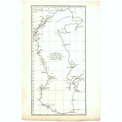
Essai D'Une Nouvelle Carte de la Mer Caspienne.
Interesting map of the Caspian Sea between Russia and Iran. Jean Baptiste d'Anville (1697-1782) born in Paris was perhaps the most important and prolific cartographer of ...
- $80 / ≈ €75
Place & Date: Paris, 1754
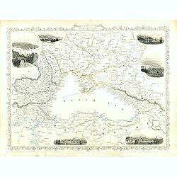
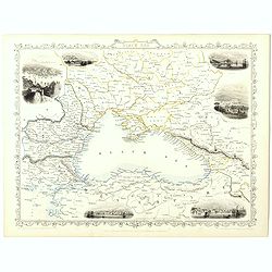
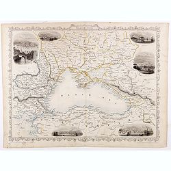
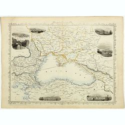
Black Sea.
Decorative steel engraved map of the Black Sea with inset views of Sebastopol and Odessa. There are also vignettes of Constantinople, Sinope and Varna. Taken from "T...
Place & Date: London, London Printing and publishing Company of London, ca. 1851
Black Sea.
Decorative steel engraved map of the Black Sea with inset views of Sebastopol and Odessa. There are also vignettes of Constantinople, Sinope and Varna. Taken from "T...
- $90 / ≈ €84
Place & Date: London, London Printing and publishing Company of London, ca. 1851
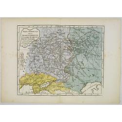
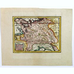
Partie Méridionale de la Russie Européenne, Tartarie, Russienne, Petite Tartarie.
Map of the southern part of Russia and Tartary. By C. F. Delamarche, successor of Robert de Vaugondy, Geographer.
- $90 / ≈ €84
Place & Date: Paris, 1806
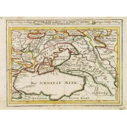
Assoph, Asow, oder Azak mit der Kleinen Tartarey dem Scwharzen Meer. . .
Scarce map showing the Black Sea region with Southern Ukraine, Georgia and Armenia.
- $100 / ≈ €94
Place & Date: Augsburg, 1715
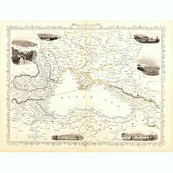
Black Sea.
Decorative steel engraved map of the Black Sea with inset views of Sebastopol and Odessa. There are also vignettes of Constantinople, Sinope and Varna. Taken from "T...
- $90 / ≈ €84
Place & Date: London, London Printing and publishing Company of London, ca. 1851
Black Sea.
Decorative steel engraved map of the Black Sea with inset views of Sebastopol and Odessa. There are also vignettes of Constantinople, Sinope and Varna. Taken from "T...
Place & Date: London, London Printing and publishing Company of London, ca. 1851

Black Sea.
Decorative steel engraved map of the Black Sea with inset views of Sebastopol and Odessa. There are also vignettes of Constantinople, Sinope and Varna. Taken from "T...
- $90 / ≈ €84
Place & Date: London, London Printing and publishing Company of London, ca. 1851
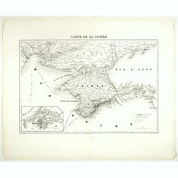
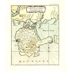
Carte de la Crimée.
Attractive map of Crimea with inset plan of Sevastopol, prepared by Alexandre Aimé Vuillemin (1812-1886). A road system and the ferry lines are drawn in.Engraved by Jaco...
- $150 / ≈ €140
Place & Date: Paris, ca. 1850
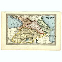
Armenia major, Iberia etc. by J.Archer.
Early Missionary map of Armenia from the "Atlas of educational maps for the use of schoolmasters" (1847), published by SPCK - the Society for Promoting Christia...
- $150 / ≈ €140
Place & Date: London, 1847
Black Sea.
Decorative steel engraved map of the Black Sea with inset views of Sebastopol and Odessa. There are also vignettes of Constantinople, Sinope and Varna. Taken from "T...
- $110 / ≈ €103
Place & Date: London, London Printing and publishing Company of London, ca. 1851
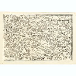
Nieuwe kaart van Muskovien door M. de l'Isle.
This lovely little map of the area surrounding Moscow is based on Delisle's map of the region. The map is bounded by Lake Ilmen in the north, the Volga River to the east,...
- $100 / ≈ €94
Place & Date: Amsterdam, 1735
![[Costume plate of Grebenski Cossacks in the Caucasus]](/uploads/cache/62339-250x250.jpg)
[Costume plate of Grebenski Cossacks in the Caucasus]
Aquatint costume plate of Grebenski Cossacks in the Caucasus. Plate N° 10. From Giulio Ferrario's work Le Costume ancien et moderne ou histoire du gouvernement, de la mi...
Place & Date: Milan, 1827
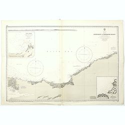
Black sea - Sheet IX - Bosporus to Kerempe Burnu . . .
A highly corrected version of Admiralty chart 2238 originally published 16th June 1854. Edition Date 1980.Detailed chart of Bosporus. With prohibited landing places in pu...
- $100 / ≈ €94
Place & Date: London, 1854-1980
Estats du Grand Duc de Moscovie.
Lovely small map of' Russia in Europe', extending from Poland and the Baltic in the west, Zembla in the frozen north, reaching down south to the Ukraine with Kiev and par...
- $150 / ≈ €140
Place & Date: Paris, 1705
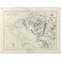
Siege of Sebastopol.
Detailed map of the Siege of Sebastopol. After the Battle of the Alma, the Allies proceeded to Sebastopol and commenced the Siege on September 26th, 1854. This is a steel...
- $150 / ≈ €140
Place & Date: London, 1854
(Untitled map of western shores of the Black Sea, with Bulgaria, Roumenia.)
Untitled map of western shores of the Black Sea, with Bulgaria, Roumenia. The map has elaborate floral borders. Prepared by Josef Schlacher in Vienna and published by K.K...
- $150 / ≈ €140
Place & Date: Vienna, K.K. Militär Geografisches Institut, 1875
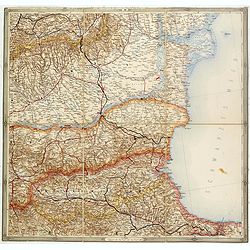
Russia in Europe Part VIII with index map.
Very detailed steel engraved map of the region north of the Black Sea, Podolia, Bessarabia, Kherson, Iekaterinoslav, Taurida, Krimea. Relief shown by hachures.The map is ...
- $150 / ≈ €140
Place & Date: London, Edward Stanford, 1864
Carte de la Crimée.
Fine map of Crimea (Ukraine) here in the only issue of this version of Bellin's map, slightly larger than the common version. From Bellin's Le Petit Atlas Maritime Recuei...
- $175 / ≈ €164
Place & Date: Paris, 1764
![[Untitled map of Black Sea].](/uploads/cache/37349-250x250.jpg)
[Untitled map of Black Sea].
Very detailed and rare map of Black Sea region. The map has elaborate floral borders. Prepared by Joseph Scheda in Vienna.
- $200 / ≈ €187
Place & Date: Vienna, 1845-1847
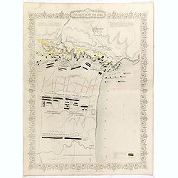
Plan of the battle of Alma.
Fine plan drawn and engraved by John Rapkin "from English and French Official Documents" Published 1858 by the London Printing and Publishing Co., London. Shows...
- $150 / ≈ €140
Place & Date: London, 1854
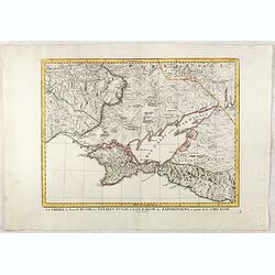
La Crimée, la nouvelle Russie, les Tatares Nugay et d'Oczakow...
Engraved by Perrier, Bourgoin and Arrivet. The map was prepared by the Venetian cartographer and publisher François (Père) Santini and first published in Santini's &quo...
Place & Date: Venice, 1784
Selling price: $110
Sold in 2015