Search Listings matching "ukraine" in Europe > Russia / Baltic / Black Sea region
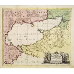
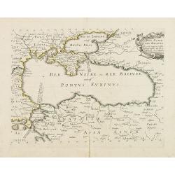
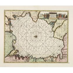
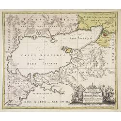
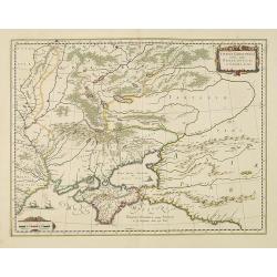
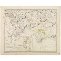
Maris Assoviensis vel de Zabache et Paludis Maeotidis. . .
A very detailed map showing the Black Sea, Azow and Rostow area.
Place & Date: Augsburg, 1720
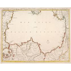
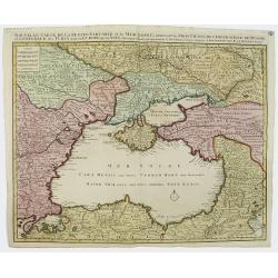
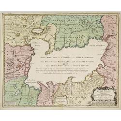
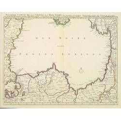
Seconde partie de la Crimee la Mer Noire. . .
The lower part of a set of two maps from the observations of Guillaume Delisle focuses on the Black Sea with wonderful detail of the surrounding regions. Includes Constan...
- $500 / ≈ €468
Place & Date: Amsterdam, 1720
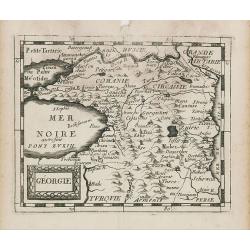
Géorgie.
Uncommon miniature map of Ukraine, from Pierre Duval's La Geographie Universeille dated 1676. Following his Cartes de geographie in 1657, Pierre Duval published this smal...
Place & Date: Paris, 1676
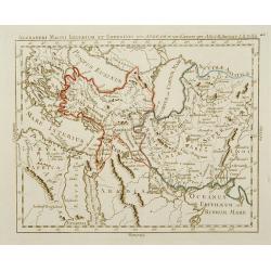
Alexandri Magni Imperium et Expeditio per Africam et potissimum per Aslam.
Rare map of the Empire of Alexander the Great, prepared by J.B.Nolin and published by Monhare for his Atlas Général a l'usage des colleges et maisons d'education.. Cent...
- $300 / ≈ €281
Place & Date: Paris, 1783
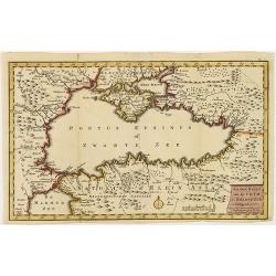
Mer Noire ou Mer Maievre, . . .
Map of the Black Sea prepared by N.Sanson and published by Pierre Mariette.Published in an early edition of the small Sanson atlas L'Europe Dediée a Monseigneur . . . Le...
Place & Date: Paris, P. Mariette, 1667
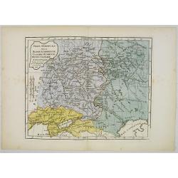
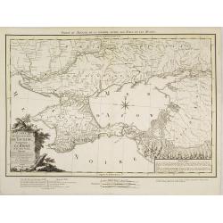
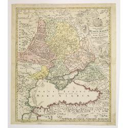
Partie Méridionale de la Russie Européenne, Tartarie, Russienne, Petite Tartarie.
Map of the southern part of Russia and Tartary. By C. F. Delamarche, successor of Robert de Vaugondy, Geographer.
- $90 / ≈ €84
Place & Date: Paris, 1806
![[Crimea]. Carte de la Cromée.](/uploads/cache/25719-250x250.jpg)
[Crimea]. Carte de la Cromée.
Mapmaker, Captain Jan Hendrik van Kinsbergen (1735-1819). Published by H. Friesman in 1787. This map first appeared in 1776 and was the first Russian map of the newly ann...
Place & Date: Amsterdam, H. Frieseman, 1787
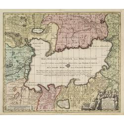
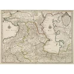
Nouvelle Carte de la Petite Tartarie et la Mer Noire, montrant les Frontieres de l'Impératrice de Russie et de l'Empereur des Turcs, tant en Europe qu'en Asie, Dessigné selon la proposition de G. De L'Isle et d'autres Auteurs.
The Ukraine and the Black Sea in a fine impression with original 18th-c. hand-coloring.
- $1250 / ≈ €1170
Place & Date: Amsterdam, 1730

Nova Maris Caspii et Regions Usbeck..
A detailed map of part of Russia, Central Asia centered on the Caspian, Uzbek territory to the east of the Caspian and northern Persia. A finely engraved, uncolored title...
Place & Date: Nuremberg, 1735
![[2 maps and one text sheet] Theatrum Belli A° MDCCXXXVII. . . / Verus Chersonesi Tauricae Seu Crimea Conspectus adjacentium item Regionem itinerisq ab Exercitu Ruthemo...](/uploads/cache/27975-250x250.jpg)
[2 maps and one text sheet] Theatrum Belli A° MDCCXXXVII. . . / Verus Chersonesi Tauricae Seu Crimea Conspectus adjacentium item Regionem itinerisq ab Exercitu Ruthemo...
[2 maps and one text sheet] Theatrum Belli A° MDCCXXXVII. . . / Verus Chersonesi Tauricae Seu Crimea Conspectus adjacentium item Regionem itinerisq ab Exercitu Ruthemo A...
- $1100 / ≈ €1029
Place & Date: Amsterdam, c. 1744
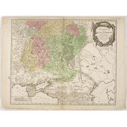
Partie Meridionale de Moscovie. . .
Scarce map centered on Moscow including Azow and part of present-day Ukraine in the bottom part of the map. The map is based on Delisle's important map of the region with...
- $750 / ≈ €702
Place & Date: Amsterdam, 1720
Carte marine de la mer Caspienne avec toutes ses Bayes Rivieres et Havres, dressée sur les observations des plus habiles Navigateurs,. . .
Strikingly engraved and attractive map of the Caspian Sea, showing major towns, ports, etc. Large decorative cartouche and compass rose.
- $500 / ≈ €468
Place & Date: Leiden, 1710
Nova ac verissima Maris Caspii ante hac maximam fere partem nobis incogniti, ac Regionum adiacentium : Delineatio Iussu Invictissimi Principis Petri Alexii Fil. Magni Russorum Imperatoris / immenso labore et maximis sumptibus facta, atque ex ...
Covers portions of Iran, Turkmenistan, Kazakhstan, Russia and Azerbaijan. Relief is shown pictorially. Depth is shown by soundings. Oriented with north to the left. Rare.
- $750 / ≈ €702
Place & Date: Amsterdam, 1720
Carte du Gouvernement de Tauride, comprenant la Krimée et les pays voisins: dressée principalement d'après la carte faite sur les lieux pour le voyage de S.M. l'impératrice de Russie. . .
Very rare map of the Crimea area published Jean-Claude Dezauche, who was active in Paris 1770-1824. The map includes borders and a road system.Dezauche is giving credit t...
- $750 / ≈ €702
Place & Date: Paris, 1788
Nova et accuratissima Maris Caspii. . .
Original hand colored copper engraving of Matthaeus Seutter. Showing the Caspian Sea with the large Volga Delta in east orientation. Main towns / countries around the Cas...
- $750 / ≈ €702
Place & Date: Augsburg, 1740

Tabula geographica Russiae Magnae pontus euxinus seu mare nigrum et tauriae regnum. . .
Decorative map of the Black Sea Region, with a large decorative cartouche. Shows Constantinople. Extends north to Moscow and Smolensko.
- $750 / ≈ €702
Place & Date: Nuremberg, 1720
Maris Assoviensis vel de Zabache et Paludis Maeotidis. . .
A very detailed map showing the Black Sea, Azow and Rostow area. With a decorative allegorical cartouche, showing the costumes of the indigenous people of the region.
- $900 / ≈ €842
Place & Date: Augsburg, 1720

Carte Marine De La Mer Caspiene levée suivant les ordres de S.M.Cz. En 1719, 1720 et 1721.
Detailed of the Caspian Sea, prepared by Karl van Verden in 1722. Van Verden was a Russian sailor and the Czar's Special Commander, who produced the first accurate map of...
Place & Date: Paris, ca. 1725

Carte de la Petite Tartarie Dresee par ordre de l'Imperatries de toutes las Russies.
The very rare first edition of De Leth's map of the southern part of Ukraine, with detailed annotations regarding the Cossacks and an explanatory key. Based on a Russian ...
- $1750 / ≈ €1638
Place & Date: Amsterdam, ca. 1785
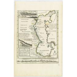
The Caspian Sea Drawn by the Czar's special command By Carl van Verden in the year 1719. 1720 and 1721. . .
Hand col. engraved map with 3 inset views. Includes geographical notes.With views of "Terky", "Derbent" and "Astracan"
Place & Date: London, 1732
Selling price: $375
Sold in 2011
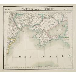
Partie Méridionale de la Russie Européenne. . .
Detailed map of Ukraine, the Crimea and the northern part of the Caspian Sea.
- $650 / ≈ €608
Place & Date: Paris, 1752
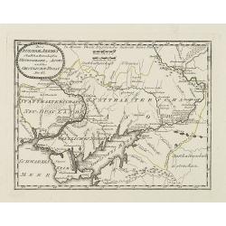
Des Russischen Reiches Statthalterschaften Neurussland, Asow, und das Oestliche Nogay
Map showing Lake Asow and the Crimea. The river Dnepr until Krementschug, and the river Don until Pawlowsk. Published by Franz Johann Joseph von Reilly.
Place & Date: Vienna, 1789
Taurica Chersonesus, Nostra aetate Przecopsca, et Gazara dicitur.
Part of Russia with in the north Smolensk and Moscow and in the south the Black Sea.As Willem Blaeu died in 1638 most of his maps are actually published by his son Joan. ...
Place & Date: Amsterdam, 1638
Europe. Partie de la Russie. N°22.
Detailed map of the Crimea region.From his famous Atlas Universel . This atlas was one of the most remarkable world atlases ever produced, anticipating the International ...
Place & Date: Brussels, 1825-1827
Selling price: $210
Sold in 2010
Seconde partie de la Crimee la Mer Noire. . .
The lower part of a set of two maps from the observations of Guillaume Delisle focusing on the Black Sea with wonderful detail of the surrounding regions. Includes Consta...
- $750 / ≈ €702
Place & Date: Amsterdam, 1720
Carte des Pays Voisins de la Mer Caspiene dressee pour l' usage du Roy. . .
Detailed and attractive map focusing on Georgia, Azerbaijan and Armenia. It depicts roads, forts, cities, villages, topography and is filled with notations.Prepared by th...
- $750 / ≈ €702
Place & Date: Paris, 1723
![[No title] Russland.](/uploads/cache/28943-250x250.jpg)
[No title] Russland.
Map depict the area north of the Black Sea, including the cities of Odessa, Kischenau, Jelisawetgrad, Kherson.From "W. E. A. von Schliebens Atlas von Europa nebst Ko...
- $250 / ≈ €234
Place & Date: Leipzig, G. J. Göschen, ca 1825-1830
![[No title] Russland.](/uploads/cache/28944-250x250.jpg)
[No title] Russland.
Map depict the area north of the Black Sea, including the cities of Jekaterinoslaw, Bachmut, Alexandrowsk.From "W. E. A. von Schliebens Atlas von Europa nebst Koloni...
- $300 / ≈ €281
Place & Date: Leipzig, G. J. Göschen, ca 1825-1830
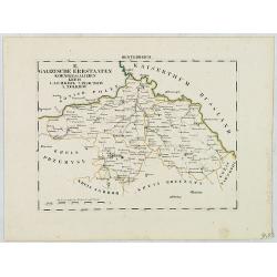
B. Galizische Erbstaaten Koenigr: Galizien Kreis 1. Lemberg 2. Zloczow 3. Zolkiew.
Map depict the western part of the Ukraine, centered on the town of Lviv (Lemberg) the former capital of the region of Galicia. Other cities are Zolkiew, Brody, Belz.From...
- $300 / ≈ €281
Place & Date: Leipzig, G. J. Göschen, ca 1825-1830
![[No title] Oesterreich. B. Galizische erbstaaten Koenigr. Galizien Kreis 12. Sambor 13. Stry 17. Stanislawow.](/uploads/cache/28948-250x250.jpg)
[No title] Oesterreich. B. Galizische erbstaaten Koenigr. Galizien Kreis 12. Sambor 13. Stry 17. Stanislawow.
Map depict the area north of the Black Sea, including the cities of Stanislawow, Drobicz, Sambor.From "W. E. A. von Schliebens Atlas von Europa nebst Kolonien für G...
- $300 / ≈ €281
Place & Date: Leipzig, G. J. Göschen, ca 1825-1830
![[No title] Russland. Gouv. 24 Woronesh 28. Slobodsk Ukraine.](/uploads/cache/28949-250x250.jpg)
[No title] Russland. Gouv. 24 Woronesh 28. Slobodsk Ukraine.
Map depict the area north of the Black Sea, including the cities of Kharkow, Achtyrka, Woronesh, etc.From "W. E. A. von Schliebens Atlas von Europa nebst Kolonien f�...
- $300 / ≈ €281
Place & Date: Leipzig, G. J. Göschen, ca 1825-1830

L'escadre alliée bombarde les forts extérieurs de Sébastopol. (18 octobre 1854)
Beautiful Crimean War lithography by Becquet after a painting by Louis Le Breton. The print illustrates the ships "Fort Constantin", "la ville de Paris&quo...
Place & Date: Paris, 1860
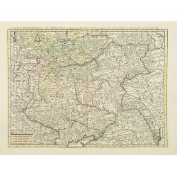
Tabula Geographica qua pars Russiae Magnae. . .
U unrecorded state Homann's map is based upon the works of George von Mengden (1628-1702), a Livonian cartographer who worked for Peter the Great and Count Jacob Bruce [G...
- $1000 / ≈ €936
Place & Date: Nuremberg, c. 1770
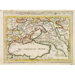
Assoph, Asow, oder Azak mit der Kleinen Tartarey dem Scwharzen Meer. . .
Scarce map showing the Black Sea region with Southern Ukraine, Georgia and Armenia.
- $100 / ≈ €94
Place & Date: Augsburg, 1715
Nieuwe kaart van de Crim de Zwarte Zee en omleggende. . .
Showing the Black Sea and the Marmara Sea with Istanbul. Published in the rare first edition of Kleyne en Beknopte Atlas, of Tooneel des Oorlogs in Europa...The atlas wa...
Place & Date: Amsterdam, 1735
Selling price: $450
Sold in 2013
Russia in Europe Part VIII with index map.
Very detailed steel engraved map of the region north of the Black Sea, Podolia, Bessarabia, Kherson, Iekaterinoslav, Taurida, Krimea. Relief shown by hachures.The map is ...
- $150 / ≈ €140
Place & Date: London, Edward Stanford, 1864
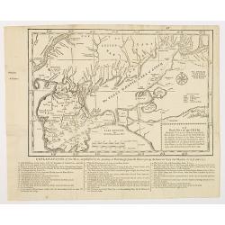
An exact map of the CRIM (Formely Taurica Chersonesus) Part of Lesser Tartary, the Sea of Asoph, and the adjacent Country of the Kuban Tartars. . .
Detailed and handsome wood block printed map centered on the Sea of Azov detailing the ongoing war between the Russians and Turks. The map is filled troop locations and b...
Place & Date: London, 1739
Selling price: $200
Sold in 2010
Charte der Kriegs Operationen am Donn u: Dnieper Ihro Russisch Kayserl Majestaet Glorieusen Armeen A: 1736
Scarce separately published map of the southern part of Ukraine, with an explanatory key A-N in the lower right. The map is surrounded by letterpress German text giving a...
Place & Date: Augsburg, 1750
Selling price: $900
Sold in 2011

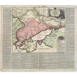
LA RUSSIE NOIRE ou POLONOISE qui Comprend les PROVINCES DE LA RUSSIE NOIRE de VOLHYNIE et de PODOLIE divisées en leurs Palatinats Vulgairement Connües sous le Nom D'VKRAINE ou PAYS DES COSAQUES.
Very rare map of the Ukraine and Poland, prepared by Sanson in 1675 in a third state, published by the heirs of Sanson, in Paris in 1706. The imprint changed to: Par les ...
Place & Date: Paris, 1706
![[MANUSCRIPT] Carte nouvelle de la Crimée et des pays circonvoisins.](/uploads/cache/30484-250x250.jpg)
[MANUSCRIPT] Carte nouvelle de la Crimée et des pays circonvoisins.
A beautiful manuscript map on paper. Showing the northern part of the Black Sea region with Crimea.Interesting are the border lines of "New Serbia", shown in th...
Place & Date: ca. 1752-1764