Search Listings matching "sea-chart"

De Cust van Barbaria, Gualata, Arguyn, en Gene..heo, van Capo S.Vincente tot Capo Verde.
An eye-catching chart of the north western coast of Africa. Including Canary Islands, Cape Verde Islands and Azores.Pieter Goos (ca. 1616-1675) was one of the most import...
Place & Date: Amsterdam, 1666

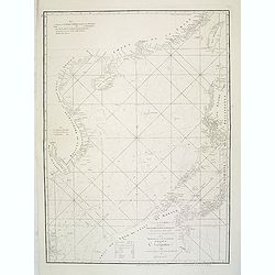
Nieuwe Wassende Graade Zee Kaart over de Spaanse Zee Vant Kanaal tot 't Eyland Cuba in Westindia. . .
¤ Engraved by I.van Anse. A very representative example of a Dutch chart of the Atlantic, showing the north-east coast of America, the coasts of Africa and Europe and So...
Place & Date: Amsterdam, 1728

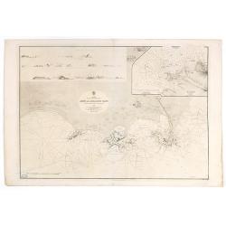
De Cust van Barbaryen van out Mamora tot Capo Blanco..
Six charts on one sheet. The two upper charts covering an area from Cape Blanc to Casablanca. In lower part four insets with detailed charts of islands as Madera, Porto S...
Place & Date: Amsterdam, 1666
A chart of the China Sea inscribed to Monsr. D'APRES de MANNEVILLETTE .. To A.Dalrymple.
Most important milestone sea chart is based upon the surveys made from navigational surveys by Alexander Dalrymple (1737-1808]. He was the first Hydrographer of the Briti...
Place & Date: Paris, ca. 1775

Pascaerte vande Vlaemsche, Soute, en Caribesche Eylanden, als mede Terra Nova,. . .
This fine and scarce sea chart covers the central Atlantic and extends to include the Maritime Provinces, Antilles and the northwest coast of South America, east to the A...
Place & Date: Amsterdam, 1672

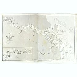
Kaart van een gedeelte van de Noord Kust van Java en Straat Sunda van Tanjong Kaik tot den vierden hoek bij Anjer..
Very large and rare chart depicting Java's northern seacoast.Coastal profiles are present at the bottom of the map.The chart is prepared by B.H.Staring, J.A.G.Rietveld an...
- $1500 / ≈ €1404
Place & Date: Amsterdam 1843-1844

Straat Sunda en Westkust van Java.
Very large and rare chart depicting Java's western seacoast close to the Sunda Strait.Showing part of Sumatra on top and the West Java tip, today hosting the Ujung Kulon ...
- $1500 / ≈ €1404
Place & Date: Amsterdam (1841)1846

Kaart van de Reede van Batavia met de verschillende vaarwaters naar dezelve trigometrisch opgenomen op last van deb schout bijnacht E.Lucas.
Very large and rare so-called blue-black chart centered on Jakarta's harbor.The chart is prepared by B.G.Escher, I.A.C. Eschauzier, B.H.Staring and E.H.Boom during an exp...
- $2000 / ≈ €1871
Place & Date: Amsterdam (1841) 1847
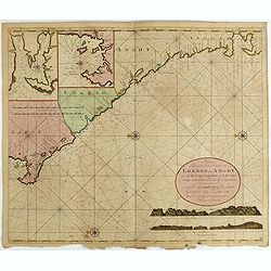
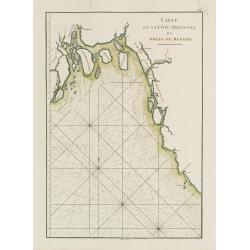
Nieuwe Paskaert van de Custen Zee Loango en Angoy van C. de Lopo Gonzalves tot R. de Zaire os Congo vertoonende alle desselfs gelegenteden.
Sea-chart of the coast of Gabon, Loango, Angoy and Angola to Zaire (Congo) River. In lower right side title and two coastal profiles. In upper left corner inset charts of...
- $300 / ≈ €281
Place & Date: Amsterdam, ca. 1715 -1751

Philippine Islands - Semirara, Ilin and Ambulong 1.s with part of Mindoro. (971)
A highly corrected version of Admiralty chart 971 originally published 15th February 1866 under the Superintendence of Captain G.H. Richards. Edition Date 1991 with furth...
- $150 / ≈ €140
Place & Date: London, 1866 / 1999
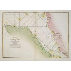
Carte Hydrographique De La Baye De Cadix. . .
Beautiful chart of the Bay of Cadiz, from Rota to Cadiz, with dramatic coastal topography, soundings, anchorages, forts, loxodromic lines, compass rose and large decorati...
- $1000 / ≈ €936
Place & Date: Paris, 1762
![[65] Surie.](/uploads/cache/12837-250x250.jpg)
[65] Surie.
Charming chart of the harbour of the town of St Jean d'Acre in Syria. Showing town and harbour plan, with soundings, anchorages, rocks, shoals, fortifications and lightho...
- $120 / ≈ €112
Place & Date: Marseille, 1764
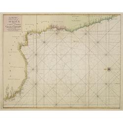
A chart of the coast of Africa from Cape Virde to Cape Bona Esperansa.
Rare and attractive chart of the western part of Africa.
- $800 / ≈ €749
Place & Date: London, 1748

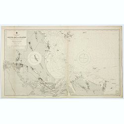
Kaart van de Gaspar Straaten volgens opnemingen van J.Stolze, D.Ross, enz.
Very large and rare chart centered on the strait between Bangka's southeastern seacoast and Belitung's western shores.Short front views of the coastal relief are shown in...
- $900 / ≈ €842
Place & Date: Amsterdam 1843
![Bay of Bengal, compiled chiefly from government survey.. [2 sheets]](/uploads/cache/23495-250x250.jpg)
Bay of Bengal, compiled chiefly from government survey.. [2 sheets]
Large scale chart in 2 sheets focused on the Bay of Bengal.It covers Sri Lanka, the whole Indian eastern coast, the seacoast of Bangladesh, Myanmar and Thailand as far as...
- $1200 / ≈ €1123
Place & Date: London (1863), corrections to 1871
![(2 charts of Shri Lanka) Mer des Indes - Ile de Ceylan - Partie Nord. Détroit de Palk et Golfe de Manaar.. [with] Partrie Sud...](/uploads/cache/23493-250x250.jpg)
(2 charts of Shri Lanka) Mer des Indes - Ile de Ceylan - Partie Nord. Détroit de Palk et Golfe de Manaar.. [with] Partrie Sud...
Two very large charts representing the northern and southern part of Sri Lanka and giving details about the Indian seacoast around the Gulf of Mannar and the Palk Strait....
- $750 / ≈ €702
Place & Date: Paris, 1866

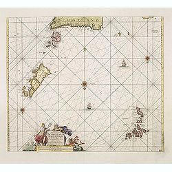
Noordoost Cust van Asia van Japan tot Nova Zemla.
An eye-catching chart of Japan, Hokkaido and the Islands to the North of Japan. In the lower left Korea and part of northern China. Korea has three names mentioned: "...
- $2000 / ≈ €1871
Place & Date: Amsterdam, 1666
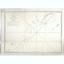
Plan de la partie des iles, ou archipel de Coree, vue au mois de Mai 1787 par les Fregates Francaises la Boussole et l'Astrolabe. . . .
Showing the track of La Pérouse along the southern most tip of Korea, with Quelpaerts Islands (now-a-days called Jeju, with the vulcano Halla-san (Halla Mountain) clearl...
- $400 / ≈ €374
Place & Date: L'Imprimerie de la Republique, An V, 1797

Carte générale de la mer des Indes dressée par P. Daussy et P.E. Wissocq, grave par Chassant, ecrit par J.M. Hacq.
Magnificent and detailed large-scale chartdepicting the Indian ocean, with east coast of Africa, Madagascar, Arabian Peninsula, India, China, etc .Including the West coa...
- $1000 / ≈ €936
Place & Date: Paris, 1837-1869
China, Sheet IX, Yang-Tse-Kiang from the sea to Nanking . . .
A fine, large-scale chart. This chart depicts the last stretch of the Yangtse River before it meets the sea. It gives soundings and notes on the tides, and includes an in...
- $750 / ≈ €702
Place & Date: London, 1843-1859
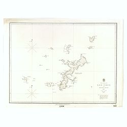
North Pacific Ocean LOO CHOO and adjacent Islands 1855.
Large scale chart of Okinawa in the Japan Sea. With scale and vignette of Typographical office. Map nr. 2416.An interesting note in lower right "The coast line of al...
- $300 / ≈ €281
Place & Date: London, 1855
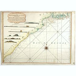
The Coast of India, from Point Gordeware to the Ganges Comprehending Part of the Coast of Golconda . . .
Detailed sea chart of the coast of India, from the mouths of the Ganges Rivers in the northeast to Point Gordeware in the south west. Includes numerous sailing channels a...
- $400 / ≈ €374
Place & Date: London, 1794

Caerte der Noordt cufte van Engelandt, beginnende van Robinhodes baij tot Coket Eijlandt. . . .
A very early Dutch text edition of this detailed chart of the northern coast of England. The mileage cartouche has no Latin captures. West to the top.Decorated by a color...
- $2000 / ≈ €1871
Place & Date: Leiden, Plantijn, 1585

De custen van een deel van Denemarken en Swede. . .
A detailed chart of the coast Skane and Kalmar, with the island Öland. Decorated by a title and scale cartouche, a compass rose, several vessels and sea monsters, and de...
- $2000 / ≈ €1871
Place & Date: Leiden, Plantijn, 1585
![[2 Sheets] Carte Générale de l'Océan Pacifique Dressée Par Mr. C. A. Vincendon-Dumoulin. . . Pl. 1. N° 1092. / Ocean Pacifique Feuille 2. . . Pl. 2. N° 1093.](/uploads/cache/26731-250x250.jpg)
[2 Sheets] Carte Générale de l'Océan Pacifique Dressée Par Mr. C. A. Vincendon-Dumoulin. . . Pl. 1. N° 1092. / Ocean Pacifique Feuille 2. . . Pl. 2. N° 1093.
Two sea charts depicting the Pacific Ocean, with nice detail of Hawaii. Sheet 1 shows the south east Asian region. The second North America and part of South America. Pre...
- $900 / ≈ €842
Place & Date: Paris, 1845, updated for 1884

Carte réduite de l'Océan Oriental, depuis Le Cap de Bonne Espérance jusqu'à l'Isle Formose.
French chart covering the seas between the Cape of Good Hope until Taiwan and the West Coast of Australia. Prepared by Jacques-François L'Abbé Dicquemare (1733-1789). L...
- $1000 / ≈ €936
Place & Date: Paris, Brest, chez Demonville, 1775
![Mer Adriatique. Côte Orientale. De l'Ile Meleda à Antivari.. [3552]](/uploads/cache/23471-250x250.jpg)
Mer Adriatique. Côte Orientale. De l'Ile Meleda à Antivari.. [3552]
This large scale coastal chart shows the stretch of Dalmatian coast between the island Mljet in Croatia as far as Ulcinj (Montenegro). With latitude and longitude scales,...
- $200 / ≈ €187
Place & Date: Paris [1877] corrected to 1934
![Environs de Raguse (Dubrovnik). Deuxième Feuille. Canal de Calamota (Kolocep).. [277]](/uploads/cache/23473-250x250.jpg)
Environs de Raguse (Dubrovnik). Deuxième Feuille. Canal de Calamota (Kolocep).. [277]
This large-scale coastal chart shows the stretch of the Dalmatian coast between Slano as far as the island of Kolocep, the southernmost inhabited island in Croatia. With ...
- $200 / ≈ €187
Place & Date: Paris [1877] corrected to 1932
![Red Sea - Strait of Jubal.. [2838]](/uploads/cache/23496-250x250.jpg)
Red Sea - Strait of Jubal.. [2838]
Large chart focused on the Strait of Jubal in the Gulf of Suez. With the Juzur Tawilah Islands at the center and an inset plan of the Tur Harbour (At Tur, South Sinai) o...
- $500 / ≈ €468
Place & Date: London (1853) corrected for 1862
Arabia. Gulf of Aden - North Coast. Aden and Adjacent Bays..
Large chart focused east of Aden, in Yemen. With inset plan of Aden Anchorage in the upper right corner and a set of coastal profiles in the upper left corner.With latitu...
- $900 / ≈ €842
Place & Date: London (1836) corrected to 1868
![Mer Adriatique. Partie Sud.. [3976]](/uploads/cache/23549-250x250.jpg)
Mer Adriatique. Partie Sud.. [3976]
This large scale coastal chart centered on the southern part of the Adriatic sea. Showing the Dalmatian coast between Split in Croatia as far as the northernmost tip of C...
- $200 / ≈ €187
Place & Date: Paris [1883] updated for 1935
Mer de Chine. Golfe du Tonkin. Entrées de Kuaï-Chin-Mun et Tsieng-Mun. . .
Large chart centred on the Gulf of Tonkin in the South China Sea. Showing banks, isles and soundings made in metres. Relief is shown by hachures.Engraved by A. Gérin aft...
Place & Date: Paris, 1887
Selling price: $300
Sold in 2008

Carte de la Baye et du Port de Trinquemalay dans L'Isle de Ceylan.
Chart showing the bay of Trincomalee, Ceylon (Sri Lanka). Trincomalee is natural deep water port on the east coast of Sri Lanka, about 110 miles northeast of Kandy. It is...
- $250 / ≈ €234
Place & Date: Paris, 1775
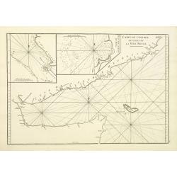
Carte de la Mer Rouge, depuis Moka jusqu'a Gedda.
Chart of the Red Sea. With 3 inset maps of Shake Omare, Goofs and Gedan.D'Après De Mannevillette (1707-1780) was one of France's first hydrographers. When the first edit...
- $450 / ≈ €421
Place & Date: Paris, 1775

Plan de la Rade de Gedda situee de la Cote d'Arabie sur la Mer Rouge.
Chart of the area around city of Gedda in the Red Sea. D'Après De Mannevillette (1707-1780) was one of Franc's first hydrographers. When the first edition of his Atlas L...
- $600 / ≈ €561
Place & Date: Paris, 1745
Carte de L'entrée du Golfe de la Mer Rouge.
Chart of the Gulf of Aden with the coast line of Yemen, the Island Socotra and the entrance of the Red Sea. With 2 inset charts off-shore of the town Mocha.D'Après De Ma...
- $400 / ≈ €374
Place & Date: Paris, 1753
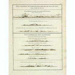
Vues diverses du fort de l'Agouade pres de l'isle de Goa . . . Sumatra . . .
French sea sea chart with 9 coastal views near Goa in India and Sumatra. The titles above the main profiles reading as following : Vues diverses du fort de l'Agouade pre...
- $200 / ≈ €187
Place & Date: Paris, Brest, Demonville, 1775

Noordoost Cust van Asia van Japan tot Nova Zembla.
Important for its early depiction of Hokkaido and the Islands to the North of Japan. Ships navigate the seas around the Siberian, Chinese and Japanese coast extending as ...
- $3000 / ≈ €2807
Place & Date: Amsterdam, 1666
Paskaart Vande Noord Cust van Schotland als mede de Eylanden van Hitland en Fero. . .
Decorative chart, with south to the top. Latitude scale, compass rose and system of rhumb lines, soundings, anchorage's, etc. In the lower right corner, with added number...
- $500 / ≈ €468
Place & Date: Amsterdam, 1753

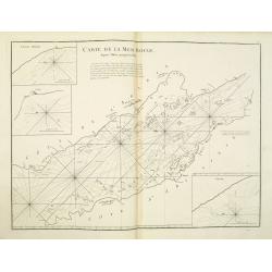
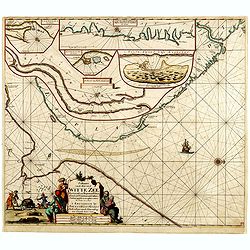
Mare Balticum. . . / Nieuwe Pascaert van de Oost Zee. . .
Decorative chart showing the Baltic sea, with a splendid cartouche of royal figures. A re-issue of the De Wit copper plates, now with many improvements.
- $2500 / ≈ €2339
Place & Date: Amsterdam ca.1680
Paskaart van de Mont van de Witte Zee,. Beginnende van Tiepena tot Pelitza, als mede van C. Cindenoes tot Catsnoes.
Fine sea chart of the southern part of the Barents Sea, oriented to the West. With 5 inset maps: - Swetenoes, de Kust van Laplandt, Lombascho, "T Vaste Landt van Lap...
- $1000 / ≈ €936
Place & Date: Amsterdam, c.1710

Carte de la Baye et du Port de Trinquemalay Dans L'Isle de Ceylan.
French chart of the harbor of Trinquemalay on the island of Ceylon. Prepared after Samuel Cornish who was a vice admiral for the English East India company.Latitude and l...
- $350 / ≈ €328
Place & Date: Paris, Brest, chez Demonville, 1775

Nieuwe gelyk Graadige Paskaart van de Kust van Guiana in West-Indien.
Detailed chart of Guiana in South America. Two scales are given in both maps: Dutch, French and English nautical miles.The inset chart provide detailed view of the Camopi...
- $650 / ≈ €608
Place & Date: Amsterdam, 1684 - 1704

Le Nouveau miroir des voiages marins de la navigation de la mer occidentale & orientale.
A second and final French edition of this important sea atlas. Two engraved frontispieces, figure with volvelle, full-page figure, 48 double-page charts (one numbered 19....
- $120000 / ≈ €112286
Place & Date: Antwerp, Chez Iean Bellere, a l’Aigle d’or, l’An M.CCCCCC (1600
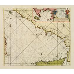
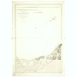
Paskaart der Zeekusten van Italien Tusschen Piombino en C. dell Arme Met de Noord-kust van 't Eylandt Sicilia..
Centered off the Ponziane Islands, this sea chart covers the area of the Tyrrhenian Sea, delimited by Sardinia, the Elba island, the Strait of Messina and Trapani. It con...
- $1500 / ≈ €1404
Place & Date: Amsterdam, 1708
Carte de la Mer comprise entre l'Australie, la Nelle. Zélande et la Nelle.
Sea chart of the Pacific Ocean between Australia, New Zealand and New Caledonia. Including the towns of Sydney, Brisbane. The northern tip of New Zealand in lower right c...
- $350 / ≈ €328
Place & Date: Paris, 1872 updated for 1888
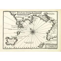
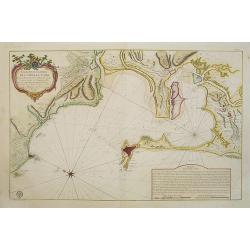
Plan du Golfe de Naples.
An attractive chart centered on the Gulf of Naples. Mount Vesuvius to the right. With scale and large compass-rose. Dated 1727, with the privilege of the King. From : Rec...
- $150 / ≈ €140
Place & Date: Marseille, 1730
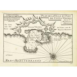
Plan de la Ville et Port de Civita-Vechia.
An attractive chart centered on Civitavecchia, a town and comune of the province of Rome in the central Italian region of Lazio.With scale and large compass-rose. Dated 1...
- $200 / ≈ €187
Place & Date: Marseille, 1730
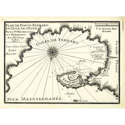
Plan de Porto Ferraro en l'isle de l'Elbe.
An attractive chart centered on the Mediterranean. With scale and large compass-rose. Dated 1727, with the privilege of the King. From : Recueil des Plusieurs plans des p...
- $200 / ≈ €187
Place & Date: Marseille, 1730
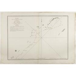
Plan de la partie des Isles ou Archipel de Corée.
Showing the track of La Perouse along the southern most tip of Korea, with Quelpaerts Islands (now-a-days called Jeju, with the volcano Halla-san (Halla Mountain) clearly...
- $750 / ≈ €702
Place & Date: Paris, 1797
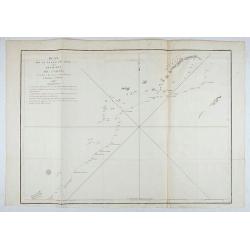
Plan de la partie des Isles ou Archipel de Coree.
Showing the track of La Perouse along the southernmost tip of Korea, with Quelpaerts Islands (nowadays called Jeju, with the vulcano Halla-san (Halla Mountain) is clearly...
- $350 / ≈ €328
Place & Date: Paris, 1797
Carte Plate de la partie Septentrionale du Detroit de Malac, depuis de la rade d'Achem jusqu'a Malac.
French chart of the Island of Sumatra and the Malay Peninsula separated by the strait of Malacca in Indonesia.Latitude and longitude scales, compass rose and system of rh...
- $500 / ≈ €468
Place & Date: Paris, ca. 1775
Carte de la Côte Orientale du Golfe du Bengale.
French sea chart of coast northeast of India. Latitude and longitude scales, compass rose and system of rhumb lines, soundings near coast and in bay areas.D' Après de Ma...
- $150 / ≈ €140
Place & Date: Paris, ca 1775
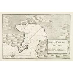
Plan du Port de Cartagene.
Sea chart of the Port of Cartagene. Marked with navigational notes.From the rare chart book by Jacques Ayrouard: Recueil de plusieurs Ports de la Mer Méditerranée...
- $200 / ≈ €187
Place & Date: Marseille, 1732-1746

Pascaert van Engelant Van t'Voorlandt tot aen Blakeney waer in te sien is de mont vande Teemse.
Two charts on one sheet. One decorative sea chart of the southeast coast of England with an inset of the Thames till London, embellished with two title cartouches, a ship...
- $750 / ≈ €702
Place & Date: Amsterdam, 1666

A plat of the East Sea. By William Fisher and Richard Mount...
An important sea chart of the East Sea with coast lines of Poland, Russia, Sweden, published by William Fisher and Richard Mount in London.Richard Mount (1654-1722) was a...
- $1800 / ≈ €1684
Place & Date: London, 1795
![Australia, E. coast - Queensland Percy isles to Whitsunday I. chiefly from a joint Admiralty & Colonial survey by Staff Commander Bedwell, R.N. 1873 to 1879 [1945]](/uploads/cache/36212-250x250.jpg)
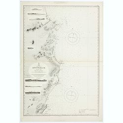
Australia, E. coast - Queensland Percy isles to Whitsunday I. chiefly from a joint Admiralty & Colonial survey by Staff Commander Bedwell, R.N. 1873 to 1879 [1945]
Large chart representing East coast of Australia with Queensland from Percy isles to Whitsunday Island, with inset of Beverley Islands Anchorage. Scale 1:74,000. in lower...
- $150 / ≈ €140
Place & Date: London, 1882-1945
East coast of Australia. New South Wales. Sheet VII, Coffs Islands to Evans Head surveyed by Comr. Fredk. W. Sidney R.N. assisted by E.P. Bedwell & J.T. Gowlland, Masters & S. Guy, 2nd Master R.N. 1864-5
Large chart representing East coast of Australia with New South Wales including Coffs Islands to Evans Head surveyed by Comr. Fredk. W. Sidney R.N. First published at the...
- $150 / ≈ €140
Place & Date: London, 1907-1943
Sheet VI East coast of Australia. New South Wales Tacking Point to Coffs Islands surveyed by Comr. Fredk. W. Sidney R.N. . . 1862 - 1864. . .
Large chart representing East coast of Australia with New South Wales including Tacking Point to Coffs Islands surveyed by Comr. Fredk. W. Sidney R.N. from 1862 - 1864. F...
- $150 / ≈ €140
Place & Date: London, 1939-1942
Sheet XII East coast of Australia Queensland Keppel Isles to Percy Isles. . .
Large chart representing east coast of Australia's Queensland showing Keppel Isles to Percy Isles with relief shown by hachures, spot heights and bathymetric soundings. S...
- $150 / ≈ €140
Place & Date: London, 1932-1944
Sheet V East coast of Australia. New South Wales Evans Head to Danger Pt. surveyed by Comr. Fredk. W. Sidney R.N. . . 1864-5. . .
Large chart representing East coast of Australia with New South Wales including Evans Head to Danger Pt. surveyed by Comr. Fredk. W. Sidney R.N. from 1864 - 1865. First p...
- $150 / ≈ €140
Place & Date: London, 1866-1943
Australia - East coast Queensland Keppel Bay and Islands surveyed by staff Commr. J.Jeffery. . . 1864. . .
Large chart representing East coast of Australia with Queensland including Keppel Bay and Islands surveyed by Comr. J.Jeffery in 1864. First published at the Admiralty 3r...
- $150 / ≈ €140
Place & Date: London, 1866-1943
Plan de la partie des iles, ou archipel de Coree, vue au mois de Mai 1787 par les Fregates Francaises la Boussole et l'Astrolabe. . . .
Showing the track of La Perouse along the southernmost tip of Korea, with Quelpaerts Islands (nowadays called Jeju, with the volcano Halla-san (Halla Mountain) clearly no...
- $450 / ≈ €421
Place & Date: L'Imprimerie de la Republique, An V, 1797
China Sea Philippine Islands - San Bernandino Strait and approaches. (3370)
A highly corrected version of Admiralty chart 3370 originally published 14th November 1924 under the Superintendence of Captain H.P. Douglas. Edition Date 1982 with furth...
- $150 / ≈ €140
Place & Date: London, 1924 / 1996

Philippine Islands - Mindanao West Coast - Basilan Strait to Camiguin Island including Tubbataha Reefs. . . (3811)
A highly corrected version of this oversized Admiralty chart 3811 originally published 26th February 1925 under the Superintendence of Captain P.H. Douglas. Edition Date ...
- $150 / ≈ €140
Place & Date: London, 1925 / 2005
Carte particuliere de la cote septentrionale d'Afrique. (13eme feuille)
A fine French Service Hydrograhique de la Marine chart no. 3424, showing Cape Rose and Cap Nègre, in Algeria, drawn in 1873 by E. Mouchez, updated to 1913. Chart engrave...
- $80 / ≈ €75
Place & Date: Paris, 1873 / 1913

Carta particolare che comincia con il c.apo Aldea è Finisce con il capo Degortam. . .
Dudley’s magnificent chart shows the south west coast of Africa. A first edition without the privilege..Engraved by Lucini.Sir Robert Dudley's Dell'Arcano del Mare is t...
- $1250 / ≈ €1170
Place & Date: Florence, 1645

De Tesselstroom met de Gaten van Marsdiep./ De Mase met. . .
Three charts on one sheet depicting the entrances to the Zuiderzee between Holland, Texel and Vlieland. The entrances of the Maas with Rotterdam and in a small inset the ...
- $500 / ≈ €468
Place & Date: Amsterdam, 1662
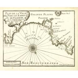
Plan de la Ville, Port et rades de Palerme. . .
An attractive chart centered on Palermo. With scale and large compass-rose. Dated 1727, with the privilege of the King. From : Recueil des Plusieurs plans des ports et ra...
- $250 / ≈ €234
Place & Date: Marseille, 1730
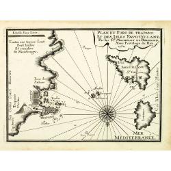
Plan du Port de Trapano et des isles Favouillane.
An attractive chart centered on Trapani on the west coast of Sicily in Italy. It is the capital of the Province of Trapani. The right the island of Favignana and Levanzo ...
- $300 / ≈ €281
Place & Date: Marseille, 1730
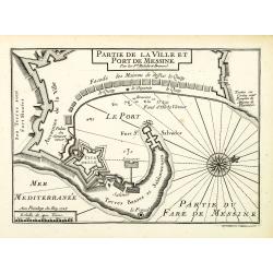
Plan de la Ville et Port de Messine.
An attractive chart centered Messina on Sicily. With scale and large compass-rose. Dated 1727, with the privilege of the King. From : Recueil des Plusieurs plans des port...
- $250 / ≈ €234
Place & Date: Marseille, 1730
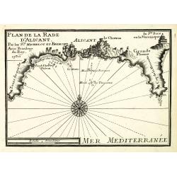
Plan de la Rade d'Alicant.
An attractive chart centered Alicante in Valencia along the Mediterranean. With scale and large compass-rose. Dated 1730, with the privilege of the King. From : Recueil d...
- $350 / ≈ €328
Place & Date: Marseille, 1730
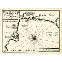
Plan de la Rade de Mayorque.
An attractive chart centered on Palma de Majorca in the Mediterranean. With scale and large compass-rose. Dated 1727, with the privilege of the King. From : Recueil des P...
- $600 / ≈ €561
Place & Date: Marseille, 1730
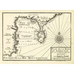
Plan de la Baye de Gibraltar.
An attractive chart centered on Gibraltar. With scale and large compass-rose. Dated 1727, with the privilege of the King. From : Recueil des Plusieurs plans des ports et ...
- $375 / ≈ €351
Place & Date: Marseille, 1730
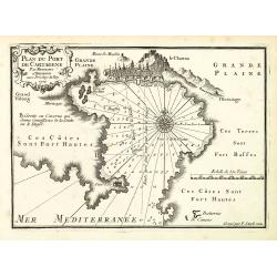
Plan du Port de Cartagène.
An attractive chart centered on the Bay of Cartagena. With scale and large compass-rose. Dated 1727, with the privilege of the King. From : Recueil des Plusieurs plans de...
- $375 / ≈ €351
Place & Date: Marseille, 1730
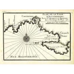
Plan de la Rade d'Ascombrera. . .
An attractive chart centered on Cartagena in Spain. With scale and large compass-rose. Dated 1730, with the privilege of the King. From : Recueil des Plusieurs plans des ...
- $300 / ≈ €281
Place & Date: Marseille, 1730
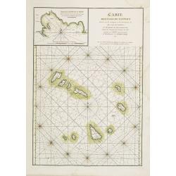
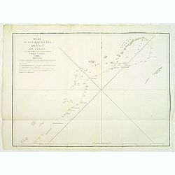
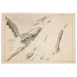
Carte des Iles du Cap-Verd Dressée sur les remarques et les observations les plus exactes des Navigateurs.
French sea chart of the Cap Verde Islands, situated 570 kilometers off the coast of Western Africa.Latitude and longitude scales, compass rose and system of rhumb lines, ...
- $100 / ≈ €94
Place & Date: Paris, Brest, chez Demonville, 1775
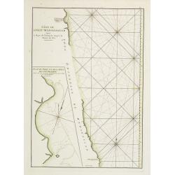
Côte de l'Isle de Madagascar depuis la Baye de Vohemare jusqu'à la pointe de l'Est. Plan du Port et de la Baye du Cap de l'Est.
French chart of the east coast of Madagascar.Latitude and longitude scales, compass rose and system of rhumb lines, soundings near coast and in bay areas.D' Après de Man...
- $100 / ≈ €94
Place & Date: Paris, Brest, chez Demonville, 1775
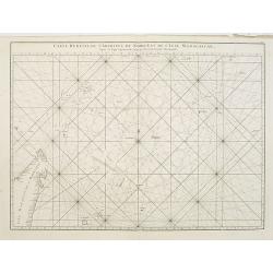
Carte réduite de l'Archipel du Nord-Est de l'Ile Madagascar.
French sea chart of an archipelago off the coast of Madagascar. The northeastern coast of Madagascar is included.Latitude and longitude scales, compass rose and system of...
- $100 / ≈ €94
Place & Date: Paris, Brest, chez Demonville, 1775
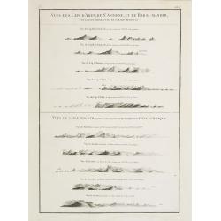
Vues des Cap d'Aden, de St. Antoine, et de Bab-El-Mandeb, sur la Côte Méridionale de l'Arabie Heureuse. Vues de l'Isle de Socotra
Coast profiles near Cape Aden in Yemen and in the lower part coastal profiles near Socotra, an island east of the Horn of Africa and 380 kilometers (240 mi) south of the ...
- $250 / ≈ €234
Place & Date: Paris, Brest, chez Demonville, 1775