Search Listings matching "east-sea" in Medieval & Oriental Manuscripts
No listings match your query.
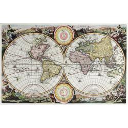
Beautiful double hemisphere from a Dutch Bible. Surrounded by allegorical representations of the continents, based on Visscher. CALIFORNIA IS AN ISLAND with a flat northe...

Fourth edition of this folding map of the Crimea. In upper right corner an inset map of the areas around the Black Sea; "The Town & Harbor of Sevastopol with the...

Detailed map of part of the country between rivers Rhine and Meuse showing a canal to be dug between 1626 and 1628 between Rheinberg in Germany and Venlo. A deficiency of...

Exquisite contemporary colored lithograph of Port Saint-Nicolmas Bay in most southern part of South America, with Dumont D'Urville's officers making landfall. Drawn by E....