Search Listings matching "philippines" in Map Types > Nautical Charts
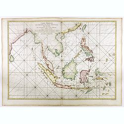
Carte réduite de l'archipel des Indes orientales avec les côtes du continent depuis le golfe de Manar jusqu'à Emoui à la Chine . . .
Important French chart of South East Asia with very good detail on Philippines. Latitude and longitude scales, compass rose and system of rhumb lines, soundings near coas...
Place & Date: Paris, 1745
Selling price: $3000
Sold in 2017

A chart of the China Sea inscribed to Monsr. D'APRES de MANNEVILLETTE .. To A.Dalrymple.
This most important milestone chart is based upon the surveys made from navigational surveys by Alexander Dalrymple (1737-1808]. He was the first hydrographer of the Brit...
Place & Date: Paris, ca 1775

North Pacific.
Huge three sheet so-called Blue-back sailing chart of the Northern Pacific including China, Korea (with Matu Is. and Liancourt), Japan, Philippines, Kamchatka, Hawaii, Al...
Place & Date: London, 1868
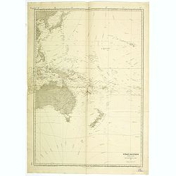
Ocean Pacifique Partie Ouest.
Large French sea chart featuring the western part of the Pacific Ocean with Australia, New Zealand, New Guinea, Philippines, till Korea and Japan, corrected in 1929.On th...
- $450 / ≈ €402
Place & Date: France, 1909-1929
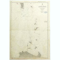
China Sea Luzon Strait between Luzon and Tai-Wan from the United States & Japanese Government chartsto 1929. . . (3804)
A highly corrected version of Admiralty chart 3804 originally published 18 September 1925 under the Superintendence of Captain P.H. Douglas. New Editions 18th December 19...
- $150 / ≈ €134
Place & Date: London, 1929 / 1992
China sea Gulf of Tongking (Southern sheet).
A highly corrected version of Admiralty chart 3989 originally published 11 Mai 1962 under the Superintendence of Captain EG Irving. Detailed chart including the coasts of...
- $80 / ≈ €71
Place & Date: London, 1962 - 1992
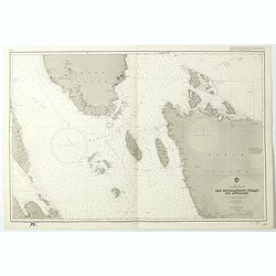
China Sea Philippine Islands - San Bernandino Strait and approaches. (3370)
A highly corrected version of Admiralty chart 3370 originally published 14th November 1924 under the Superintendence of Captain H.P. Douglas. Edition Date 1982 with furth...
- $150 / ≈ €134
Place & Date: London, 1924 / 1996

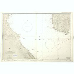
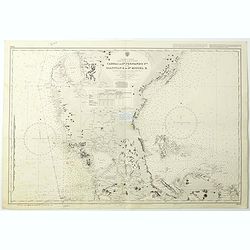
Philippine Islands - Semirara, Ilin and Ambulong 1.s with part of Mindoro. (971)
A highly corrected version of Admiralty chart 971 originally published 15th February 1866 under the Superintendence of Captain G.H. Richards. Edition Date 1991 with furth...
- $150 / ≈ €134
Place & Date: London, 1866 / 1999

Philippine Islands - Mindanao West Coast - Basilan Strait to Camiguin Island including Tubbataha Reefs. . . (3811)
A highly corrected version of this oversized Admiralty chart 3811 originally published 26th February 1925 under the Superintendence of Captain P.H. Douglas. Edition Date ...
- $150 / ≈ €134
Place & Date: London, 1925 / 2005
Philippine Islands - Luzon - west and east coast. Cabra I. to S.n Fernando P.t. Diapitan B. to S.n Miguel B. . . (3806)
Detailed chart of Luzon Island with Manila Bay, Cabra Island to S. Fernando Point Diapitan Bay to S. Miguel Bay.A highly corrected version of Admiralty chart 3806 origina...
Place & Date: London, 1922 / 2006
Selling price: $100
Sold in 2018