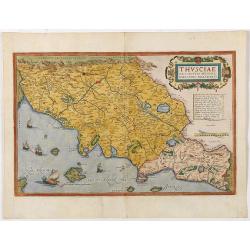
Thusciae Descriptio Auctore Hieronimo Bellarmato.
Decorative and detailed map of Tuscany, from the 1574 or 1575 Latin text edition of Ortelius' Theatrum Orbis Terrarum, the first modern atlas of the world. The map is bas...
Place & Date: Antwerp, 1574-1575
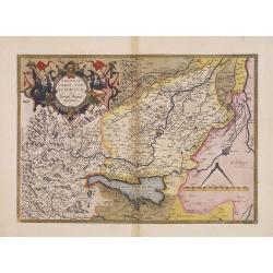
Veronae Urbis Territorium.
Very fine map of part of Italy centered on Verona, Vizenza and Lake Garda. Prepared by Bernardino Brugnoli, which first was published in 1574 by Forlani. Ortelius' map is...
Place & Date: Antwerp, 1584
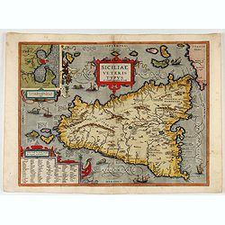
Siciliae Veteris Typus.
A very beautiful early map of ancient Sicily. Title cartouche centered on the upper part: includes also an inset map of Syracuse in the upper left, and a list of the town...
- $600 / ≈ €513
Place & Date: Antwerp, 1587

Latium.
Based on classical authors' sources, specifically Virgilius, Plinius, Varro, Halicarnasseus, Festus and Ausonius.Philip Wingius in his letter to Ortelius from 1592 mentio...
Place & Date: Antwerp, 1595

Florentini Dominii Fidelissima et nova descriptio.
The map is centered on the city of Florence and extends to Liguria, the Apennine Mountains, the Adriatic Coast, Siena and Lago di Perugia. The map is based upon Stefano B...
Place & Date: Anvers, 1598
![Larii Lacus Vulgo Comensis Descriptio . . . [and] Terretorii Romani Descrip. [and] Fori Iulii Vulgo Frivli Typus. . .](/uploads/cache/41008-250x250.jpg)
Larii Lacus Vulgo Comensis Descriptio . . . [and] Terretorii Romani Descrip. [and] Fori Iulii Vulgo Frivli Typus. . .
Set of 3 maps of Lake Como, the region around Rome and the region around the Upper Adriatic, centered on Udinese from 'Theatrum Orbis Terrarum [Atlas of the Whole World]'...
Place & Date: Antwerp, 1598
Patavini territorii../ Tarvisini agri typus.. (2 maps on one sheet)
Two maps on one sheet. Map to the left is a detailed map including Venice and the area north of it, including Padua and Vincenza. Very fine map after Giacomo Gastaldi. Th...
- $300 / ≈ €256
Place & Date: Antwerp, 1598