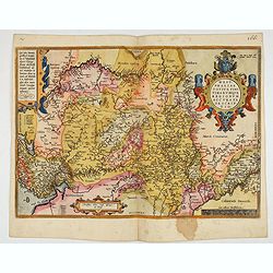
Westphaliae Totius, Finitimarumque Regionum Accurata Descriptio.
A very beautiful hand colored copper engraved map of North Rhein-Westphalia by A. Ortelius. This is a general map of Westphalia and the surrounding regions in northwest G...
Place & Date: Antwerp, ca 1584

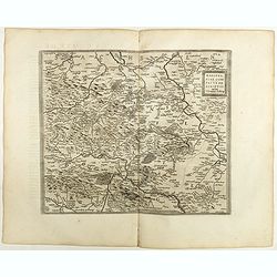
Prussiae Regionis Sarmatiae Europae Nobilissimae Novaet vera descriptio . . .
Nice example of the first edition of De Jode's map of Prussia, from the 1593 edition of De Jode's atlas.The present map is an entirely new addition to the second De Jode ...
- $2200 / ≈ €1881
Place & Date: Antwerp, 1593
Mansfeldiae Comitatus.
A very fine map centered on the city of Mansfelt . A very nice title cartouche in the upper right corner. Signed by the engraver Franz Hogenberg lower left. Abraham Ortel...
- $75 / ≈ €64
Place & Date: Antwerp, 1598
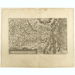
Palatinatvs Bavariae . . . / Argentoratensis agri . . .
From 'Theatrum Orbis Terrarum [Atlas of the Whole World]. The left-hand map of Bavaria is after Erhart Reych's 4-sheet map of 1540. Including the towns of Regensburg, Nü...
- $100 / ≈ €85
Place & Date: Antwerp, 1598
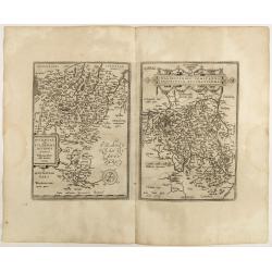
Buchaviae / Waldeccensis Comitatus.
Two maps on one sheet. The map on the left is based on Wolfgang Regerwyl's 1574 single fulda map. The map of Waldeck is based on Joist Moers map of 1572. Abraham Ortelius...
- $100 / ≈ €85
Place & Date: Antwerp, 1598