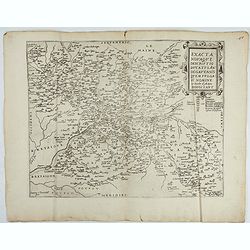
Exacta novaqve descriptio dvcatvs Andegravensis qvem vvlgari nomine Le Duche d'Aniou Indigitant.
Centered on the town of Angiers. From the first edition of De Jode's Speculum Orbis Terrarum, the second general atlas of the world, after Ortelius. Engraved by Ioannes V...
- $750 / ≈ €641
Place & Date: Antwerp, 1578
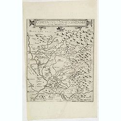
Comitatus Venayscinensis Nova Discriptio.
Rare map depicting part of Provence with Avignon, Cavaillon, Orange, Carpentras, etc.Gerard De Jode was the great rival of Ortelius, both made a living out of selling map...
- $325 / ≈ €278
Place & Date: Antwerp, 1593
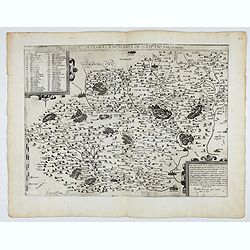
Nova et integra caenomaniae descriptio vulg. Le Mans.
Fine separately issued example of Gerard De Jode's map of Caenomaniae (Maine Province), from his Speculum Orbis Terrarum. Gérard de Jode (1508? -1590) published in Antwe...
Place & Date: Antwerp, ca. 1593

Artois. Atrebatum Regionis Vera Descripto.
Prepared by Jacob Surhon, who made a manuscript map of Artois for which he received 36 Livres from Charles V in 1554. For security reasons, the map was not published. Onl...
Place & Date: Antwerp, 1598
Artois. Atrebatum Regionis Vera Descripto.
Prepared by Jacob Surhon who made a manuscript map of Artois for which he received 36 Livres from Charles V in 1554. For security reasons the map was not published. Only ...
- $500 / ≈ €427
Place & Date: Antwerp, after 1612
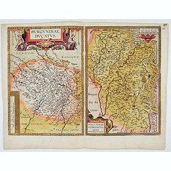
Burgundiae Ducatus. Burgundiae Comitatus.
Separately issued map of Burgundy area. Two maps of Burgundy region on a plate. Separately published map, without text on the verso. Second state with the date 1597 remov...
Place & Date: Antwerp, after 1612
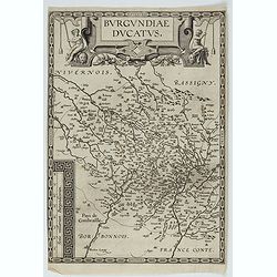
Burgundiae Ducatus.
Map of Burgundy region without text on the verso. Second state with the date 1597 removed from the title cartouche. This is the rarest Burgundy map of the four that Ortel...
- $500 / ≈ €427
Place & Date: Antwerp, after 1612

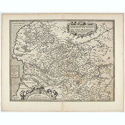
Typus Galliae Veteris, Ex conatib' Geograph. Abrah.Ortelii.
A very decorative map with countries of ancient France prepared by Abraham Ortelius and published by one of the most famous map publishers, Willem Blaeu.
Place & Date: Amsterdam, 1645