Search Listings matching "ortelius" in Europe > Eastern Europe

Schlavoniae, Croatiae, Carniale.. Bosniae. . .
First state. Fine and early map of former Yugoslavia after a map of Hirschvogel (1552-1565) and used by A.Ortelius in his atlas 'Theatrum Orbis Terrarum [Atlas of the Who...
- $400 / ≈ €342
Place & Date: Antwerp, 1579

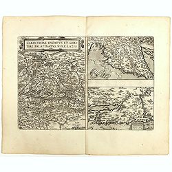
Carinthiae et Goritiae... / Histria tabula.../ Zarae, et Serebenici ..
Three maps on one sheet. The left hand is centered on the eastern part of Austria. The right upper hand map is centered on northern Yugoslavia, and the last map is center...
Place & Date: Antwerp, 1598

Romaniae, (quae olim Thracia dicta) ..
Very fine map centered on the Danube area. The map is based on the double sheet map by Jacob Gastaldi. Abraham Ortelius (1527-1598) was a cartographer and publisher, who ...
Place & Date: Antwerp, 1598
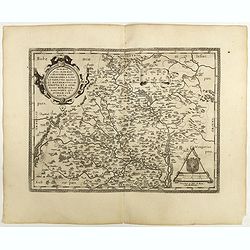
Moraviae.
This early map of Slovakia was prepared by Paul Fabritius in 1569, centered on the city of Brno. Title cartouche on the upper left corner. Abraham Ortelius (1527-1598) wa...
Place & Date: Antwerp, 1598
Carinthiae et Goritiae .. / Histria / Zarae / Serebenici. . .
Three maps on one sheet. The left hand is centered on the eastern part of Austria. The right upper hand map is centered on northern Yugoslavia, and the last map is center...
Place & Date: Antwerp, 1598

Moravia Marchionatus. Merhern.
First state of this rare map by Pieter van den Keere. The title runs across the top of the map. In the upper left a view of "Brin", in the lower right corner a ...
- $1800 / ≈ €1539
Place & Date: Amsterdam, Pieter van den Keere, [before 1623
Moravia Marchionatus. Merhern.
Second state of this rare map by Pieter van den Keere, published by Abraham Janssonius with the following imprint added : “Abrahamus Janssonius Excud : 1625".The t...
- $1600 / ≈ €1368
Place & Date: Amsterdam, Abrahamus Janssonius, 1625