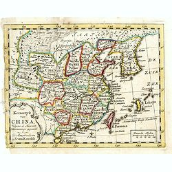
Het Keizerryk van China, volgens de Nieuwste Waarneminge opgesteld.
A scarce and uncommon miniature map of China, Korea and Taiwan. The map is of interest for the use of De Zuid Zee for the sea between Korea and Japan.
- $300 / ≈ €256
Place & Date: Amsterdam, 1745
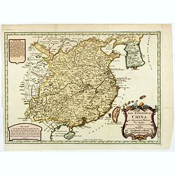
Das Kaiserthum China zur allgemeinen Historie der Reisen - entworfen von N. Bellin Ing. De la Mar. 1748.
Attractive and detailed map of China and Korea. The map is of interest for the use of Das Meer von Korea for the coast along the east coast of Korea. The composition is n...
- $500 / ≈ €427
Place & Date: Leipzig, Arkstee & Merkus, 1746
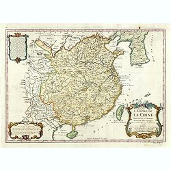
L'Empire de la Chine.
A fine map of China, Korea and Taiwan.Jacques Nicholas Bellin (1703-1772) was one of the most important and proficient French cartographers of the mid-eighteenth century....
- $450 / ≈ €385
Place & Date: Paris, 1748
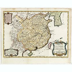
L'Empire de la Chine. . .
A fine map of China, Korea and Taiwan.Jacques Nicholas Bellin (1703-1772) was one of the most important and proficient French cartographers of the mid-eighteenth century....
- $450 / ≈ €385
Place & Date: Paris, 1748

A new & accurate map of the Empire of China from the Sieur Robert's Atlas. With improvements.
An excellent early engraving of China and Korea that appeared in Sieur Robert de Vaugondy's Geographical Dictionary (London: 1759). Decorative title cartouche on the uppe...
Place & Date: London, 1759
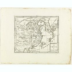
La China e Giapone.
Rare map of China, Korea and Japan, from "Atlante Novissimo ad uso Dei Giovani Studiosi Contenuto In Carte XXVII.", published by Giovanni Zempel in Rome, ca. 17...
- $300 / ≈ €256
Place & Date: Rome, 1780

La China e Giapone.
Uncommon map of China, Korea, Japan and Taiwan (I.Formosa), only one town labeled, Tayoan. Very strange shape for Japan.The map is of interest for the use of Mar di Corea...
Place & Date: Italy, ca. 1800