Search Listings matching "ortelius" in Asia

Tabula Asiae IIII. (Cyprus, Holy Land, Syria, Jordan, Iraq)
Gastaldi's map showing Cyprus, the Holy Land, Syria, Jordan and Iraq, based upon Ptolemy's map It is one of the earliest obtainable maps of the region.From Giacomo Gastal...
- $350 / ≈ €308
Place & Date: Venice, 1548
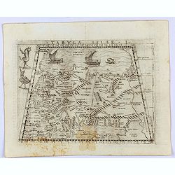
Tabula Asiae I.
Gastaldi's map of Asia Minor and the Bosporus Straits, based upon Ptolemy.It is one of the earliest obtainable maps of the region .From Giacomo Gastaldi's Atlas of 1548 w...
- $400 / ≈ €352
Place & Date: Venice, 1548
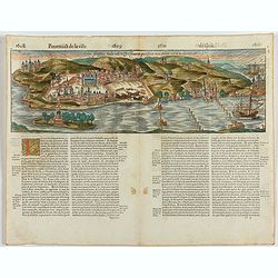
Goa fortissima Indiae urbs in Christianorum potestatem anno Salutis 1509. devenit.
A rare and early woodcut view of Goa in India. Decorated with one ship. This woodcut was published in La Cosmographie Universelle de tout le monde, printed 1575 in two vo...
Place & Date: Paris, 1575
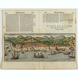
Plan, et figure de la riche cité de Calecut en la premiere Inde.
A rare and early woodcut view of Calcutta in India. Decorated with several ships on the sea, shipbuilding, fishermen and elephants.This woodcut was published in La Cosmog...
Place & Date: Paris, 1575
Primae Partis Asiae.
The Very Rare First State. Turkey/ Holy Land/ Iran/ Iraq/ Arabia/ Afghanistan. A superb example of the rare 1578 edition of this fine map of the Middle East, spanning fro...
- $4500 / ≈ €3962
Place & Date: Antwerp, 1578
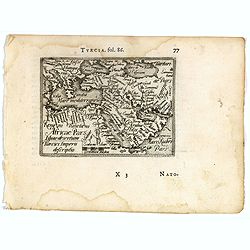
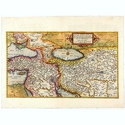
Turcici imperii descriptio.
Fine map of the Middle East, extending from Greece to Arabia and covering the Cradle of Civilisation region.Abraham Ortelius (1527-1598) was a cartographer and publisher ...
- $550 / ≈ €484
Place & Date: Antwerp, 1583
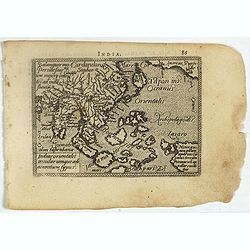
Indiae Orientalis, Insularumque Adiacentium Typus.
Map of Indonesia. From a French text edition of this illustrated treatise of geography, which is considered as the first modern pocket-atlas.Map engraved by Philip Galle....
- $500 / ≈ €440
Place & Date: Antwerp, 1585

Calecuty Regnum
A rare and unusual depiction of the Indian Ocean between Madagascar, Ethiopia, southern Arabia, and south India and Ceylon.The calligraphy is florid and decorative. The e...
- $2000 / ≈ €1761
Place & Date: Cologne, 1596
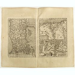
Natoliae Quae Olim Asia Minor, Nova de Scriptio / Carthaginis Celeberrimi Sinus Typus / Aegypti re Centior de Scriptio
Three detailed regional maps by Ortelius from his "Theatrum Orbis Terrarum", the world's first modern atlas.The first map covers Asia Minor, Cyprus and the East...
Place & Date: Antwerp, 1598
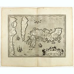
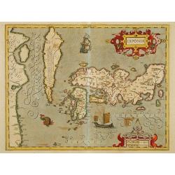
IAPONIAE INSULAE DESCRIPTIO.Ludoico Teisera auctore.
The map was based upon the manuscript draft supplied to Ortelius in about 1592 by the famous official Portuguese chart maker, Luis Teixeira , who was the cartographer t...
Place & Date: Antwerp, 1598

Terra Sancta.
This is the most modern of Ortelius' maps of the Holy Land. It focuses specifically on the Holy Land and is oriented with east of the top. Ortelius used as a model the wa...
Place & Date: Antwerp, 1603
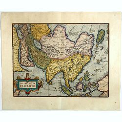
Asiae nova descriptio.
Ortelius' fine map of Asia well represents the continent at a time when Europeans were expanding their power in the Far East. The Indian subcontinent and Malaysian penins...
- $2250 / ≈ €1981
Place & Date: Antwerp, 1603
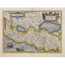
Terra Sancta quae in Sacris Terra Promissionis ol: Palestina.
Map of Palestine on both sides of the Jordan, the shore line running from Berithus (Beirut) to Gaza.Oriented to the east.Largely based on Ortelius 1584 map. In lower left...
- $675 / ≈ €594
Place & Date: Amsterdam, 1606
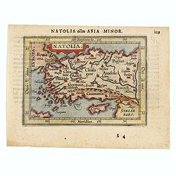
Natolia olim Asia Minor.
Genuine antique map "Natolia" by Abraham Ortelius from Epitome Theatri Orbis Terrarum, published in Antwerp in 1609. This charming 400-year-old miniature copper...
- $200 / ≈ €176
Place & Date: Antwerp, 1609
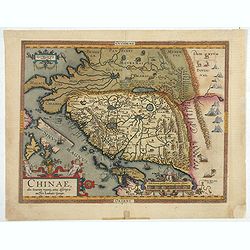
Chinae, olim Sinarum Regionis, nova descriptio. Auctore Ludovico Georgio.
The first map of China ever to appear in a Western atlas, west to the top. When this map appeared, it was by far the most accurate one of China.The map is based on a manu...
- $5500 / ≈ €4843
Place & Date: Antwerp, 1608 /1612
Japonia.
Jodocus Hondius' fine map early 17th-century map of the islands of Japan, was first issued as one of the new maps in the expended Mercator Hondius Atlas of 1606.The map i...
- $1500 / ≈ €1321
Place & Date: Amsterdam, 1606-1620
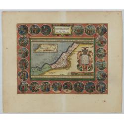
Abrahami Patriarchae Peregrinatio et Vita.
The Holy Land map itself occupies the center and is surrounded by vignettes of the life of the Patriarch Abraham. Extremely decorative map made by Ortelius, based on Ptol...
- $2800 / ≈ €2465
Place & Date: Antwerp, 1624
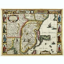
The Kingdome of China.
A most sought-after map of China. Decorative border vignettes including views of the cities of Quinzay and Macao along the top border with the wheeled wind machines and p...
Place & Date: London, G. Humble, 1626

The Kingdome of China.
A most sought-after map of China. Decorative border vignettes including views of the cities of Quinzay and Macao along the top border with the wheeled wind machines and p...
Place & Date: London, G. Humble, 1627
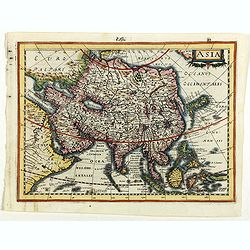
Asia.
Asia map from the rare Cloppenburg edition slightly larger format and more scarce edition of the Mercator/Hondius "Atlas Minor". Engraved by Pieter Van Den Keer...
Place & Date: Amsterdam, 1630
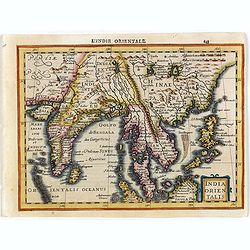
India Orientalis.
Map covering India, Thailand, Philippines, Northern Borneo and the coast of Southern China. From the rare Cloppenburg edition "Atlas Sive Cosmographicae Meditationes...
- $550 / ≈ €484
Place & Date: Amsterdam, 1630

China Veteribus Sinarum Regio.
Based on Jesuit surveys, the map represents the next major revision in the cartography of China after Ortelius' 1584 map. Korea, however, is still an island, and Japan co...
Place & Date: Amsterdam, 1640

Peregrinations divi Pauli Tyrus Corographicus. . .
A beautifully executed and very rare map showing the peregrinations of St. Paul in the Eastern Mediterranean. The Mediterranean is ornated with two ships and two sea mons...
Place & Date: Paris, ca. 1640