Browse Listings in Africa > North Africa > North Africa

De Cust van Barbaryen van out Mamora tot Capo Blanco..
Six charts on one sheet. The two upper charts covering an area from Cape Blanc to Casablanca. In lower part four insets with detailed charts of islands as Madera, Porto S...
Place & Date: Amsterdam, 1666
![[69] Barbarie.](/uploads/cache/12841-250x250.jpg)
[69] Barbarie.
Charming chart of the harbour of the province of Barbarie in Syria. Showing town and harbour plan, with soundings, anchorages, rocks, shoals, fortifications and lighthous...
- $75 / ≈ €70
Place & Date: Marseille 1764
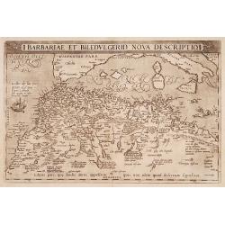
Barbariae et Biledulgerid, nova descriptio.
North-West Africa. Koeman speculated: In view of the important trading relationship between Antwerp and Africa, it is not impossible that the original was a manuscript ma...
- $300 / ≈ €281
Place & Date: Antwerp, 1587
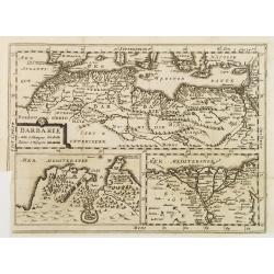
BARBARIE.
An uncommon and delightful map of Northern Africa extends from today's territory of Morocco as far as the Red Sea.With Inset maps of the Nile Delta and the Gulf of Tunis.
- $100 / ≈ €94
Place & Date: Amsterdam, 1700
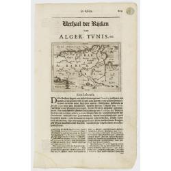
Tunetanum Regnum.
Small map representing Tunisia and Algeria, surrounded by text in Dutch.Nicolaes de Clerck (de Klerc) was active as engraver and publisher in Delft from 1599-1621.Include...
Place & Date: Amsterdam, Cloppenburch, 1621
Partie de la Barbarie ou sont les royaumes de Tunis et Tripoli. . .
Coastal map of Tunisia and Libya prepared by N.Sanson and published by Pierre Mariette.Published in an early edition of the small Sanson atlas L'Europe Dediée a Monseign...
- $750 / ≈ €702
Place & Date: Paris, P. Mariette, 1667
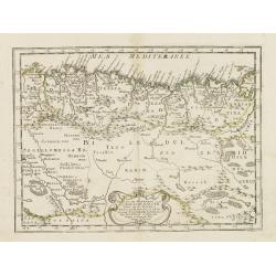
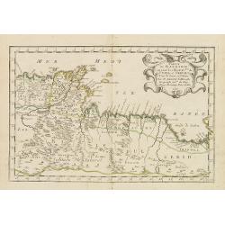
Partie de la Barbarie ou est le royaume d'Alger. . .
Coastal map of North Africa prepared by N.Sanson and published by Pierre Mariette.Published in an early edition of the small Sanson atlas L'Europe Dediée a Monseigneur ....
- $80 / ≈ €75
Place & Date: Paris, P. Mariette, 1667
Marok Alger et Tunis. / Etat de Tripoli.
Two maps on one sheet. Finely engraved map of North Africa and Libya, prepared by A.H.Dufour and engraved by Giraldon-Bovinet. Published by Jules Renouard in his uncommon...
- $40 / ≈ €37
Place & Date: Paris, Jules Renouard, ca.1840

.Tabu nova partis Aphri.
Based on Waldseemüller's map. The maps show Northern Africa as it was known to Europeans at the first part of the 16th century. There is great details across north Afric...
Place & Date: Lyons, M. Servetus, 1535
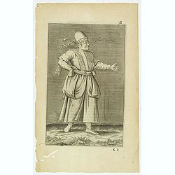
Esclave More. (38)
Sought-after copper engraved plate of a Moor slave from North Africa. Plate from Laonikos Chalcocondyle’s "L'histoire de la décadence de l'empire grec et establis...
- $75 / ≈ €70
Place & Date: Paris, Mathieu Guillemot, 1650