Browse Listings
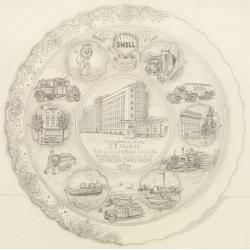
Shell : 9 Februari 1911-1951.
Decorative design-drawing in lead pencil offered to mr. J.E. Talens for his 40 years jubilee at the Shell foundation : Aangeboden aan J. E. Talens ter gelegenheid van zij...
Place & Date: Gouda, ca. 1951
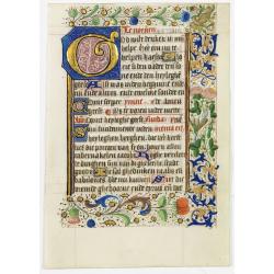
Leaf on vellum, from a manuscript book of hours.
Scatter border of flowers. Borders of very high quality, executed by an artist of the Ghent-Bruges school.VERSO: 19 lines of Dutch text in brown ink. A 6-lines capital &q...
Place & Date: Flanders, 1450

Plan du Port de St Augustin dans la Floride.
This chart shows a plan of the Port of St. Augustine in Florida.The only issue of this version of Bellin's map, slightly larger than the common version. Depths shown by s...
Place & Date: Paris, 1764
![Posesiones de America : Isla de Cuba. [together with] Isla de Cuba. . .](/uploads/cache/23458-250x250.jpg)
Posesiones de America : Isla de Cuba. [together with] Isla de Cuba. . .
Wall size sea chart and map of land areas showing all of Cuba, part of Florida Keys plus San Adios and Salvador Grande in the Bahamas.Minute topographical, political, and...
Place & Date: Madrid, 1853 / 1851

Sincapour.
Early view of Singapore after Paris and engraved in aquatint technique by Sigismond Himely (1801-1872). Published as plate 28 in Voyage autour du monde par les mers de l'...
Place & Date: Paris, Finot, 1835
![Itroductio. [with sphere.]](/uploads/cache/23703-250x250.jpg)
Itroductio. [with sphere.]
Introduction leaf from a French text edition of Atlas Ma1or
Place & Date: Amsterdam, 1662
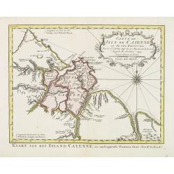
Carte de L'Isle de Caiene et de ses environs.
Uncommon edition of this accurate map of Cayenne. In lower right engraved "31."From Atlas Portatif pour servir a l'intelligence de l'Histoire Philosophique et P...
Place & Date: Amsterdam, 1773

Tabula Magellanica.
A map with Willem Blaeu's signature, but published by his son Joan, of South America's extremity with the Strait of Magellan and Le Maire Strait.The coastlines are depict...
Place & Date: Amsterdam, 1658
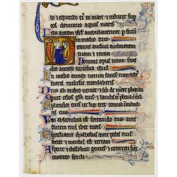
Illuminated leaf from a lithurgical Psalter with King David.
Very fine illuminated leaf from a lithurgical Psalter in Latin with the reading from the Vulgate Bible. Lines in a slightly irregular gothic hand, black ink, plummet ruli...
Place & Date: Flanders, Rhineland, or possibly England, c. 1280

Carte Geo-Hydrographique du Golfe du Mexique et de ses Isles..
Map of the Caribbean and Gulf of Mexico showing the various islands and continental coastlines according to the 18th century Venetian cartography of Rizzi Zannoni.Illustr...
Place & Date: Paris, ca 1783
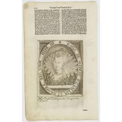
Maria De Medices D. G Galliae et Navarrae Reg. Uxor Henr. IIII.
The engraving depicts a half length oval portrait of Marie de' Medici, queen consort of France .Nicolaes de Clerck (de Klerc) was active as engraver and publisher in Delf...
Place & Date: Amsterdam, Cloppenburch, 1621
![Hong Kong. [Queen's Road]](/uploads/cache/24362-250x250.jpg)
Hong Kong. [Queen's Road]
Finely executed watercolor made by Henri Dieth of a charming atmospheric street scene at Queen's Road in Hong Kong. The watercolor is made after Eduard Hildebrandt (1818-...
Place & Date: Germany, 1882
![Hongkong Piratenstrasse. [Pirate Street]](/uploads/cache/24363-250x250.jpg)
Hongkong Piratenstrasse. [Pirate Street]
Finely executed watercolor made by Henri Dieth of a charming street scene at "Pirate Street" in Hong Kong. The watercolor is made after Eduard Hildebrandt (1818...
Place & Date: Germany, 1882

Runde Strasse in Peking.
Finely executed water color made by Henri Dieth of a charming street scene in Peking. The water color is made after Eduard Hildebrandt (1818-1869). Hildebrandt, was born ...
Place & Date: Germany, 1882
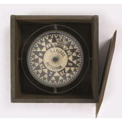
Compass.
A very nicely crafted sloop compass in original box. The compass is gimbaled and is executed in beautiful red copper. Made and signed by F.J. Kloos & Son of Rotterdam...
Place & Date: Rotterdam, 1850-1875
![[The creation of the world - First day]](/uploads/cache/24509-250x250.jpg)
[The creation of the world - First day]
Attractive page from the Nuremberg Chronicle, showing the creation of the world: the First Day, showing the celestial choir (God\'s creation of the angels) surrounding th...
Place & Date: Nuremberg, 12 July 1493

Royaume de Bohéme, Marquisat de Moravie, et Silésie Autrichenne.
Small detailed map of today Czech Republic. From Atlas Portatif Universel, by Robert de Vaugondy.Unrecorded state with erased date. Page 32 outside border top right. Mary...
Place & Date: Paris, later than 1749

III. Carte de la Hollande.. Over-Yssel.
Attractive small map centered on the delta of the River Ijssel, where it discharges into the Zuiderzee.From Atlas Portatif Universel, by Robert de Vaugondy. Unrecorded st...
Place & Date: Paris, later than 1748

VI. Partie du Duche de Gueldre où se trouve la Veluwe.
Attractive small map covering the northwestern part of Gelderland. In the center "'t Loo". From Atlas Portatif Universel, by Robert de Vaugondy.Unrecorded state...
Place & Date: Paris, later than 1748
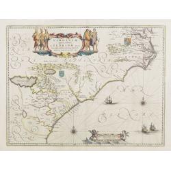
Virginiae Partis Australis, et Floridae Partis Orientalis.
Blaeu based this map on the Mercator-Hondius of 1606. A number of geographical improvements, however were incorporated, although two large fictions lakes accompanied by e...
Place & Date: Amsterdam, 1640

Plan der Stadt Quebec Haupstadt in Neu Franckreich oder Canada.
Town-plan of Quebec, with an inset view of the town in the lower right corner. In the upper right a recapitulation of the main military actions prior to the surrender of ...
Place & Date: Nurnberg, 1770
![[ Hong Kong / Canton ] Nieuwe Pas=Caart strekkende van Pta Cataon tot Pta. Lamtoan, langs de kusten van Cochinchina, Tonquin, Quangsi en Quantung [?] van Macao.](/uploads/cache/24951-250x250.jpg)
[ Hong Kong / Canton ] Nieuwe Pas=Caart strekkende van Pta Cataon tot Pta. Lamtoan, langs de kusten van Cochinchina, Tonquin, Quangsi en Quantung [?] van Macao.
A finely engraved and detailed chart of Vietnam reaching to Macao and present-day Hong Kong..Very rare: only included in the 6th volume (so-called secret atlas) of Van Ke...
Place & Date: Amsterdam, 1753

Nouvelle Mappa Monde.
State 2 of this fine double hemisphere world map, from an unusual perspective, with a "Mer de L'Ouest" or "Sea of the West". Paris is located at the c...
Place & Date: Venice, 1776 - 1784

CANTON Kong-Teheou.
Very detailed (1:1.000.000) map centered on Macao and Victoria Island, showing soundings, English, Australian, Danish telegraph lines reaching Hong Kong and extended to M...
Place & Date: Paris, 1898 updated for june 1904

Carte des côtes du Golfe du Mexique compris entre la pointe sud de la presqu'Ile de la Floride et la pointe nord de la presqu'Ile d'Yucatan: Dresée d'après le observations et las plans des espagnols, ...
Detailed and important early chart of the Gulf Coast and Florida and dated 1800. First French edition of "the first printed [map] to show and name Galveston Bay&qu...
Place & Date: Paris, 1800
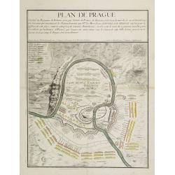
Plan de Prague.
Rare and separately published plan of Prague published by Joan Baptista Nolin with the address à l'enseigne de la Place des Victoires et chez le Sr. Humblot rue St. Jacq...
Place & Date: Paris, ca. 1742

Chorographia Terrae Sanctae in Angustiorem. . .
Rare. Large visually rich map decorated with illustrations of the sacred objects and places of Judaism. In the bottom center is a plan of ancient Jerusalem, and the route...
Place & Date: Amsterdam, ca. 1700

Matching set of four wallmaps of America, Asia, America, Europe.
Rare and decorative set of four wall maps published by Louis Charles DESNOS ( fl.1750-1770), including a border with vignettes describing native scenes. Each panel is acc...
Place & Date: Paris, 1760-1761

Sumatrae et insularum Locorumque nonnullorum circumiacentium. . .
Fine depicting the Island of Sumatra and the southern coasts of Malaysia from Quedo to Johore.North is orientated to the left of the page.Singapore is probably identifie...
Place & Date: Amsterdam, 1660

Les jeunes voyageurs en Europe, ou description raisonnée des divers pays compris dans cette partie du monde.
The second edition of this fine travel companion is illustrated with 16 very decorative maps, each map surrounded by local products and specialties of the region. Include...
Place & Date: Paris, Thiériot, 1827

Isola d'Oleron, nella piaggie occidentali della Francia.
A beautiful and rare map showing île d'Oleron.The remarkable Vincenzo Coronelli (1650-1718), encyclopaedist, geographer, inventor and Doctor of Theology, was citizen of ...
Place & Date: Venice, 1690

Beschrijvinge vande de zee Cuften va Vlanderen en Picardien. . .
DUTCH TEXT EDITION. A detailed chart of the coast of Flanders and Normandy decorated by a large colorful baroque title cartouche, and the coat of arms of Flanders with a ...
Place & Date: Leiden, Plantijn, 1585

De zee cuften tufschen Dovere en Orfords nesse, daer de Teemse de Vermaerde Rivire van Lonen gelegens is. . .
A detailed chart of the English Channel coastland. Decorated by a colorful title cartouche and scale cartouche, one compass rose, several vessels and sea monsters. A very...
Place & Date: Leiden, Plantijn, 1585

Belchrijuinghe vande zee custen van Engelandt. . .
A rare Dutch text edition of this detailed early chart of the northern coast of England. West to the top. The mileage cartouche has no Latin captures. Decorated by a colo...
Place & Date: Leiden, Plantijn, 1585

Zee caerte vande Sondt tvermaerste van Danemarcke . . .
A detailed chart of the coast of Denmark and its islands, Copenhagen in the center of the chart. West to the top. It is decorated by a title, scale and descriptive cartou...
Place & Date: Leiden, Plantijn, 1585

Africa juxta navigationes et observat recentissimas. . .
Miniature map of Africa, a reduction of the Seutter folio map based on Homann''s cartography of 1715. Very detailed - much of it fictitious. The Nile is shown not only or...
Place & Date: Augsburg, J.M.Will, 1778
![[Title page] Perspective die hooch-gheroemde conste..](/uploads/cache/25554-250x250.jpg)
[Title page] Perspective die hooch-gheroemde conste..
Title page from Perspective, Dat is, de hooch-gheroemde conste eens schijnende in oft door-siende ooghen-ghesichtespunt ... (&c.) by Hans, or Johannes Vredeman de Vri...
Place & Date: Leiden, 1604
![[Butterflies]](/uploads/cache/25587-250x250.jpg)
[Butterflies]
Plate CXXIV from Carl Gustav Jablonsky and J.F.W. Herbst: "Natursystem aller bekannten in- und ausländischen Insecten", engraved by Bodenehr. Carl Gustav Jablo...
Place & Date: Berlin, J. Pauli, 1785-1806

Walachia Servia, Bulgaria, Romania.
The cartographer of this map was Gerard Mercator. This attractive map of the Eastern Balkans is centered on Bulgaria and includes the Bosphorus and Constantinople. The Da...
Place & Date: Oxford, 1680

Carte des parties Nord et est de l'Asie..
Five maps on one sheet show the Northern Russian territories in Europe and Asia, including the western coastline from Siberia, Japan, and Korea with the island of "Q...
Place & Date: Paris, 1779