Browse Listings

Province de Pologne contenant 22 Col. une M.on Prof 5 Pen. 2 Nov. 6 Rés. 30 Maisons 1050 Jésuites.
Rare map of Poland from "Atlas Universel indiquant les établissemens des Jésuites: avec la manière dont ils divisent la terre, suivi desévénemens remarquables d...
Place & Date: Paris, Ambroise Dupont , 1826

Tabula nova Poloniae et Silesiae.
Second state, dated 1630 underneath the title. A finely engraved carte á figures with cartouche representing in the four corners of the map : Kings ( on the left side Si...
Place & Date: Amsterdam, 1630
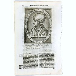
Solimannus Turcarum Imperator X. Ex Stirpe Ottomannicae.
The engraving depicts a half length oval portrait of "Solimannus Turcarum Imperator X", signed lower right corner N. de Cleck". Nicolaes de Clerck (de kler...
Place & Date: Amsterdam, Cloppenburch, 1621
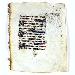
Leaf on vellum from a manuscript Book of Hours.
14 Lines of text in Latin and three 1-line initials in blue on colored grounds.RECTO: 14 Lines of text in Latin and three 1-line initials in blue on colored grounds with ...
Place & Date: France, ca.1470
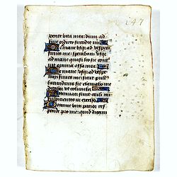
Leaf on vellum from a manuscript Book of Hours.
14 Lines of text in Latin and three 1-line initials in blue on colored grounds.RECTO: 14 Lines of text in Latin and four 1-line initials in blue on colored grounds with l...
Place & Date: France, ca.1470

Le Cours de l'Elbe et de l'Oder où sont les Electorats de Saxe et de Brandebourg, les Duchés de Mekelbourg et de Pomeranie. . .
A detailed and scarce map showing the rivers Elbe and Oder in Germany and Poland. Dark engraving.This is one sheet of the four sheet wall map by Pierre Du Val entitled: &...
Place & Date: Paris, 1684

Insularum Moluccarum Nova description.
Exquisite map of the famous Spice Islands based on the islands described by Jan Huyghen van Linschoten. This map was the first large-scale map of the region and depicts t...
Place & Date: Amsterdam, 1730

Chinae, olim Sinarum Regionis, nova descriptio. Auctore Ludovico Georgio.
The first map of China ever to appear in a Western atlas, west to the top. The first state without "las Philiooinas" somewhere in 1587 added to the plate. When ...
Place & Date: Antwerp, 1584

Carte des Isles d'Acores.
Uncommon and detailed map of the Azores. With inset maps of Port de St.Cruz and harbor and town of Angra on the island of Terceira. It was at the time an important port a...
Place & Date: Amsterdam, 1730
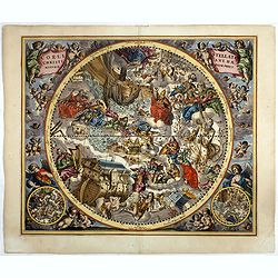
Coeli Stellati Christiani Haemisphaerium Prius.
Scarce first issue. This spectacular celestial chart presents the constellations according to Christian symbolism. The view of the constellations is based on the work of ...
Place & Date: Amsterdam, 1660