Browse Listings

Maris Pacifici.
From the rare Dutch text edition of the Theatrum of which according to van den Broecke only 100 copies are printed.This was the first printed map to be devoted solely to ...
Place & Date: Antwerp, 1598
-250x250.jpg)
Vues du port de Llivourne. (set of 6 prints)
Sought-after complete suite of 6 engravings by S[tefano] Della Bella [1610-1664]. in a second state (of 2).Della Bella was born in Florence in 1610, and studied the art ...
Place & Date: 1654-1655

Parte orientale della China.. / Parte occidentale della China. (2 sheets)
The map depicts the eastern part of China with Korea -correctly- as a peninsula. Formosa is included as well. Japan is partly visible i.e. the area of Yamaguchi, strait K...
Place & Date: Venice, 1695

Desciption de lopulente et manifique ville de Venise.
Extremely rare panoramic view of Venice and neighboring islands (Murano, Burano, Torcello and Mazorbo), clearly depicting the city's architectural landmark. The surroundi...
Place & Date: Paris, 1646

Le Isole di Sandwich delineate sulle osservazioni del Cap Cook.
FIRST EDITION on laid paper. Cassini’s splendid map depicts Sandwich islands, old name for Hawaii islands, at the end of the eighteenth century. The splendid cartouche ...
Place & Date: Rome, 1798

Profil de la renomée ville et port d'Emstredam cappitalle des estats de Hollande.
Extremely rare panoramic town-view of Amsterdam seen from the river IJ.Exceptional bright, sharp example.The print is skillful copy of the print of Matthieu Merian, now w...
Place & Date: Paris, 1647
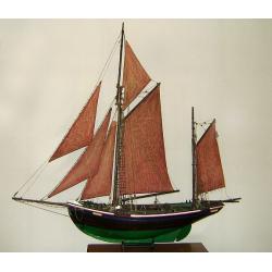
MAUREEN Shipping model of a fishing boat.
This type of fishing ships were used by the Dutch fisherman to fish for codfish, and even reached with them into the Canadian waters.Overall dimensions: 1400 x 100 x 230m...
Place & Date: Netherlands, ca. 1850

The Kingdome of China.
A most sought-after map of China. Decorative border vignettes including views of the cities of Quinzay and Macao along the top border with the wheeled wind machines and p...
Place & Date: London, G. Humble, 1627

Histoire Naturelle, Civile, Et Ecclésiastique..'
First French edition, published by P. Gosse, J. Neaulme and B. Lakeman. The basic work on Japan from the second half of the 17th century when it was still forbidden for f...
Place & Date: Amsterdam, 1729

Occidentalis Americae partis.
The most beautifully engraved early map of the Caribbean, including Florida and the Southeast. The map includes representations of Columbus' ships and various notes regar...
Place & Date: Frankfurt, 1594