Browse Listings
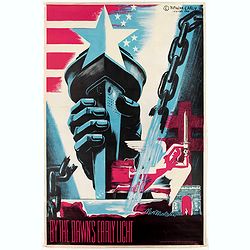
By the Dawn's Early Light.
Original 1940's WW II American liberation poster by Natacha Carlu, published by the French Press & Information Service, New York, N. Y.The poster shows a torch-bearin...
Place & Date: New York, French press and information service, 1945

Langwasser Stanislau Neu Brandenburg Mei 1942 Juni 1945
Map met reproducties van crayontekeningen van Krijgsgevangenschap in Langwasser, Stanislau en Neu-Brandenburg, Mei 1942 -juni 1945.Uitgegeven april 1948 door het Minister...
Place & Date: Den Haag, April 1948

Kaart van Palestina voor oud- en nieuw testament behorend bij de weg met en naar Christus door Fr. M. Bellarminus.
Original vintage illustrated map wall map sized poster (166 x 118cm) of Palestine in the time of Christ featuring a map of the old and new testament of the Bible from The...
Place & Date: Utrecht, Sint Gregoriushuis, 1948

Du sang à l'aube.
Original lithographed poster for the Spanish movie "Blood at dawn" (1948) directed by Rafael Gil, based on the novel by Blasco Ibanez. Poster designed by Duccio...
Place & Date: Paris, 1948

Plan commercial de la Région Saïgon-Cholon.
Decorative publicity plan of Ho Chi Minh City, also known by its former name of Saigon and Cholon, prepared by Ngo-Trinh, surrounded by advertisements of local stores. Th...
Place & Date: Saigon, 1948

Key Map of Hong Kong Relative to Canton and Macao.
A nice folded map of Hong Kong and the surrounding areas. Produced by the British Crown Lands Survey Office just after WWII. Physical features are shown by contour. Railw...
Place & Date: Hong Kong, 1948
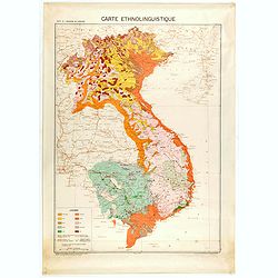
Carte de l'Indochine au 1 : 2.000.000. Carte ethnolinguistique.
Map showing Vietnam, Cambodia, and Laos, prepared under the direction of "l'Ecole Française d'Extrême-Orient". Relief shown by spot heights. With a colored ke...
Place & Date: Hanoï, 1949

Coast to Coast.
A game board that features a map of the U.S. with a built-in spinner. Players travel a circular track around the map visiting landmarks as they go. A fun way to learn geo...
Place & Date: New York, ca. 1950
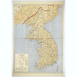
Official War map of Korea.
A large folding map of Korea published in the year of the outbreak of the Korean War, published by the Rand McNally Company. The map is extremely detailed and features a ...
Place & Date: America, ca 1950
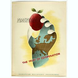
Prosperity - The Fruit of Cooperation.
NATO poster for European Cooperation by Brian E. Dear. On the poster the slogan "Prosperity the fruit of cooperation". The poster is showing a hand holding an a...
Place & Date: Kühn & Zoon Rotterdam, 1950