Search Listings matching "pacific" in World Maps
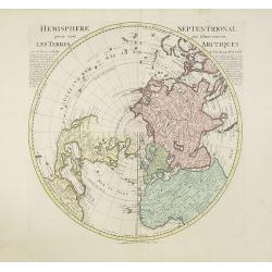
Hemisphere septentrional pour voir plus distinctement les terres arctiques. . .
Showing the Northern Hemisphere with North America, the Arctic, the Pacific, Asia and Europe after the cartographic source by the French map maker Guillaume De Isle. The ...
Place & Date: Amsterdam, c. 1740
Selling price: $1200
Sold in 2023

Le globe terrestre representé en deux plans-hemispheres, Dressé sur la Projection de Mr. De la Hyre...
“This splendid GlobeTerrestre originally published by J.B. Nolin is one of the finest large-scale world maps to be produced and is a fitting bridge between the geograph...
Place & Date: Paris, c. 1780
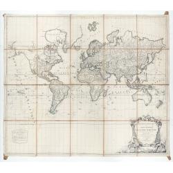
Mappemonde ou carte générale du globe terrestre dessinée suivant les règles de la projection des cartes réduites…
Large world map showing the sea tracks of Captain Cook in his three Pacific voyages published by C. F. Delamarche.Rare state 4, dated 1786, of this large world map, featu...
Place & Date: Paris, Robert de Vaugondy/Delamarche, 1786
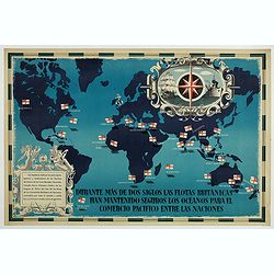
British Empire Trade Map WWII Eric Fraser.
Original vintage World War Two period British Empire trade map poster with the stylised text in Spanish reading: For more than two centuries the British fleets have kept ...
Place & Date: England, 1941