BÜNTING, H. - Itinerarium Sacrae Scripturae.
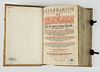
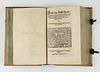
BÜNTING, H. - Itinerarium Sacrae Scripturae. Das ist: Ein Reisebuch, Uber die gantze heilige Schrifft, in zwey Bücher geteilet... Zuvor gemehret mit einem Büchlein De monetis et mensuris... Insonderheit aber mit einer feinen nützlichen Erklerung des Buches Josua... (Magdenburg, 1587). Size book block 13.0 x 8.7 inches / 33 x 22 cm.
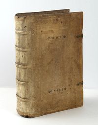
2 works in 1 vol. Folio. Bound in period pigskin over wooden boards, elaborately tooled in blind, borders of vines and portraits around the central panel, two clasps; some spotting and rubbing. Deleted stamp and ownership inscription to the title. Old ownership inscription on title from Martin Stänngl, 1589 (perhaps Martin Stängl who was the town clerk of Wels, Germany).
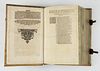
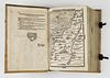
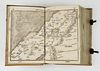
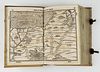
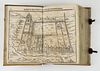
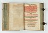
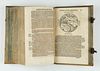
The plate of the temple and a full-page map of Palestine in the second part with marginal defects with slight loss.
The single-sheet map of the Holy land with shaved margin. Usual slight browning and staining throughout.
Nevertheless a very desirable item.
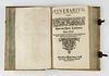
 Itinerarium Sacrae Scripturae. Das ist: Ein Reisebuch, Uber die gantze heilige Schrifft, in zwey Bücher geteilet... Zuvor gemehret mit einem Büchlein De monetis et mensuris... Insonderheit aber mit einer feinen nützlichen Erklerung des Buches Josua... Mit einer Vorrede des Herrn D. Martini Chemnitii.
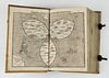
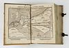
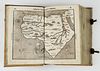
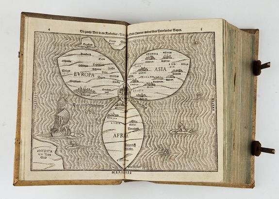
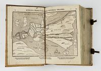
Early German edition of Bünting's Itinerarium illustrated with 12 (10 double-page) woodcut maps and plans: 2 world maps (including the famous world map in the form of a cloverleaf (Shirley 142) with the three principal continents, Europe, Asia and Africa, are arranged in the form of a cloverleaf with Jerusalem at the center.
Three countries lie outside this trefoil: England, Scandinavia, and in the lower left-hand corner, America. Sea monsters and mermaids adorn this uniquely designed cartographic curiosity.
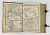
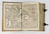
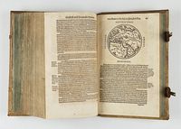
 Other landmark maps caricatures Asia in the form of Pegasus and Europe as a Queen: one of the most remarkable early cartographic curiosities. Spain is shown with a crown indicating its leadership in Europe. Italy as the right arm and Denmark as the left. Although apparently female, it has been suggested that the figure represents Emperor Charles V.
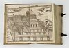
Asia as Pegasus, Africa, two of the Holy Land, Egypt, map of the Eastern Mediterranean and plans of Jerusalem and the temple.
Together with: Uber das Buch Josua;
Together with: De monetis et mensuris sacrae scripturae.
Reference : I. VD 16, ZV 31708 and B 9167; IA 127.702-05; Tobler 209; for the maps Shirley, World 142-143 (A. 1581), Laor 140-143, Zacharakis 501, Hill, Curiosities 46 and 47 (with illustration.) also
Tooley, Oddities 2, 3, 88. van der Heijden, Bünting in: Cartogr. Helvetica 23, p.5.
 Bound together with a first edition of : Nachenmoser von Brandwälden, Adam. - Prognosticon theologicum. Das ist: Gaistliche grosse Practica auß Hailiger Biblischer Schrifft und Historien. Von der Welt Naahe und Garauß. Inhaltend, die verwunderlichsten Veraenderungen im Kirchenstand und allen Policeien ... Alles nun erstmals vorgestellt und zusamen getragen.
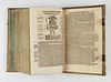
10., 18, 118, 127pp, 1 full sheet, title in black and red. With 2 woodcuts in text.
Leiden, Wernher Jobsson (Strasbourg, Bernhard Jobin), 1588.
- First edition of this curious, Reformation shaped world history and prognostics, especially directed against the Papacy and the Ottoman Empire.
The dissolution of the pseudonym is controversial, it is often ascribed to Johann Fischart (most recently by Eymer), ADB XXIII, 698 mentions the theologian Georg Nigrinus as the author. (Schwartz). A second edition appeared in 1598.
Price : POR
Including a round world map of the eastern hemisphere.
Reference : II. VD 16, N 19; Goed. II, 505, 78; Muller 593, 182; Ackermann I, 593.