Browse Listings in America > Caribbean & Atlantic Ocean
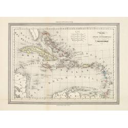
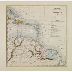
Antille od Indie Occidentali per il geografo T.Duvoteney.
Uncommon Italian map of Caribbean. Map is in outlined color.Many Indian names and settlements.From Geografia Storica and published by Fratelli Doyen in Turin.
Place & Date: Turin, 1857
Selling price: $50
Sold in 2023
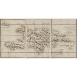
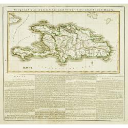
Mapa de la isla de Santo Domingo.
Impressive map of Saint Domingo. Includes indexed inset map of Santo Domingo 'Plan de la ciudad de Santo Domingo y de suyos contornos', distance tables and a coastal prof...
Place & Date: Paris, 1858
Selling price: $850
Sold in 2017
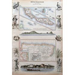
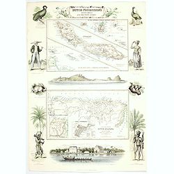
Dutch Possessions in South America and the West Indies.
Large sheet with two maps showing Dutch possessions in the Caribbean and South America. The top map shows Curaçao in large scale, also Saba, and St. Martin. The bottom m...
Place & Date: London, c1860
Selling price: $130
Sold in 2015
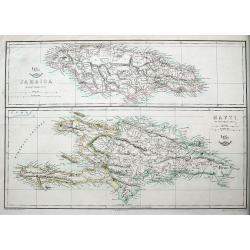
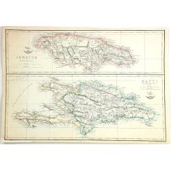
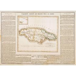
Jamaica; Hayti.
Two maps on one sheet, both very detailed with many place names, roads, hills, etc.The Weekly Dispatch newspaper was published in London between the years 1856 and 1862,...
Place & Date: London, ca 1860
Selling price: $25
Sold in 2018
Dutch Possessions in South America and the West Indies.
Two maps are shown: one of the island of Curaçao with insets of the Leeward and the Lesser Antilles and a map of the northern part of Dutch Guyana with insets of a plan ...
Place & Date: London, 1860
Selling price: $185
Sold in 2020
Jamaica & Hayti
Two maps on one sheet, the top showing Jamaica, and the bottom, the island of Haiti and Hispaniola. Published at the "Weekly Dispatch" Office in London in 1863...
Place & Date: London, 1863
Selling price: $5
Sold in 2016
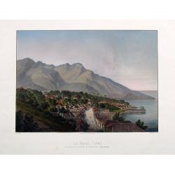
La Basse-Terre, vue prise de la Batterie de l'Impératrice, (Guadeloupe).
A fantastic view of the town from the rare and important series La Guadeloupe pittoresque by Armand Budan, published in 1863. Lithograph by Emile Vernier, and printed by...
Place & Date: Paris, 1863
Selling price: $100
Sold in 2017
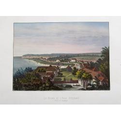
Le Bourg de L'Anse Bertrand. Grand Terre (Guadeloupe).
A fantastic view of Anse-Bertrand, from the rare and important series La Guadeloupe pittoresque by Armand Budan, published in 1863. Lithograph by Emile Vernier, and print...
Place & Date: Paris, 1863
Selling price: $300
Sold in 2020
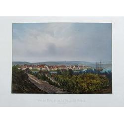
Vue du port et de la ville du Moule.
A fantastic view of Le Moule, from the rare and important series La Guadeloupe pittoresque by Armand Budan, published in 1863. Lithograph by Emile Vernier, and printed by...
Place & Date: Paris, 1863
Selling price: $300
Sold in 2020
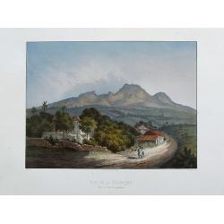
Vue de la Souffrière prise de Versailles (Guadeloupe).
A fantastic view of the Soufrière volcano ,taken from the rare and important series La Guadeloupe pittoresque by Armand Budan, published in 1863. Lithograph by Emile Ver...
Place & Date: Paris, 1863
Selling price: $325
Sold in 2020
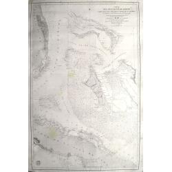
Carta del gran banco de Bahama parte de la isla de Cuba y costa de la Florida.
A scarce chart of the Bahamas, from Grand Bahama to Cuba and from Florida to the Exumas. In Florida it shows Fort Jupiter, Boca Raton, Miami, Jessup, Fort Lauderdale, etc...
Place & Date: Madrid, 1866
Selling price: $700
Sold in 2020
Mer des Antilles. Carte des passages entre Cuba, La Jamaique et la cote des mosquitos. . .
Detailed centered on Jamaica and the Cayman Islands. Engraved by Chassant and the text by Carré. Lighthouse have a yellow/red dot and additional red printed explanation...
Place & Date: Paris, 1867
Selling price: $50
Sold in 2018
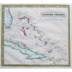
Bahama Islands.
A scarce and very detailed map of the Bahamas, including a part of Florida, Cuba, and Hispaniola. Map shows many islands, shoals and rocks. Names also the Hole in the Wal...
Place & Date: ca. 1870
Selling price: $35
Sold in 2017
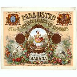
Para usted Real é Imperial frabrica de cigarros de Eduardo Guillo Habana.
Original chromo lithographed advertising poster by Testu & Massin, for the Spanish tobacco company Eduardo Guillo. Printed in Paris by Bognard & Dechavanne and R....
Place & Date: Paris, Bognard & Dechavanne and R. de la Perle, ca. 1870
Selling price: $380
Sold in 2019
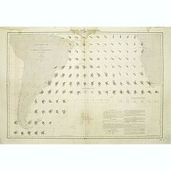
Atlantique sud carte de la direction et de l'intensité propable des vents. . . Juillet, Aout, Septembre.
Map of the south of Atlantic Ocean. Showing South America and South Africa and the different wind directions for July, August, and September prepared by L.Brault.
Place & Date: Paris, 1876
Selling price: $95
Sold in 2011
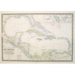
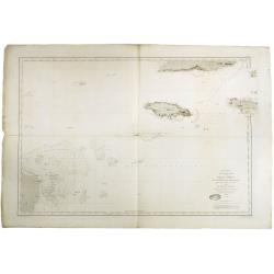
Carte générale des Iles Antilles, des iles et bancs de Bahama, des Etats-Unis . . .
Scarce and large (614 x 930 mm / 24.2 x 36.6 inches) map of the Caribbean, including the Gulf coast and central America, and insets of the Virgin Islands, Martinique and ...
Place & Date: Paris, 1876
Selling price: $100
Sold in 2023
Carte des Colonies Françaises aux Antilles.
Uncommon map including Venezuela, French Guiana, Suriname, and the islands in the Caribbean. With a color key to the French, English, Spanish, Dutch and Danish possession...
Place & Date: Paris, Abel Pilon & Co., c.1880
Selling price: $75
Sold in 2012
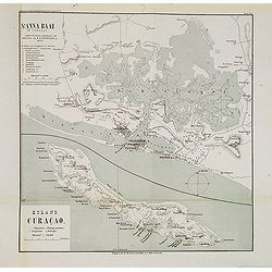
St. Anna Baai op Curaçao. / Eiland Curaçao.
Very detailed (1:20.000) lithographed map of St. Anna Bay, including Willemstad with the historic center of the city with Punda and Otrobanda. on the island Curaçao as s...
Place & Date: Amsterdam-Utrecht, K.N.A.G./ C.L.Brinkman, J.J.Beijers, 1882
Selling price: $95
Sold in 2013
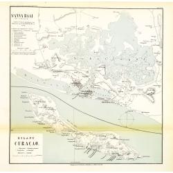
St. Anna Baai op Curaçao. / Eiland Curaçao.
Very detailed (1:20.000) lithographed map of St. Anna Bay, including Willemstad with the historic center of the city with Punda and Otrobanda. on the island Curaçao as s...
Place & Date: Amsterdam-Utrecht, K.N.A.G./ C.L.Brinkman, J.J.Beijers, 1882
Selling price: $95
Sold in 2015
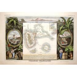
Colonies Francais en Amerique - Guadaloupe & St. Martin's.
Beautiful map of the Caribbean Islands of Guadeloupe and Grande Terre. The map is surrounded by several elaborate decorative engravings designed to illustrate the richnes...
Place & Date: Paris, 1882
Selling price: $99
Sold in 2015
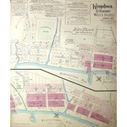
Kingston, St. Vincent. West Indies.
Large, uncommon fire insurance plan is presented on a scale of 120 feet to one inch. Lists the town with a population of 6000, from which 1/12 is white. Explains the main...
Place & Date: Montreal/Toronto, 1897
Selling price: $250
Sold in 2014
![[ATLAS] Maps of the Bahama Islands with statics and index.](/uploads/cache/37319-250x250.jpg)
[ATLAS] Maps of the Bahama Islands with statics and index.
A rare atlas of the Bahama Islands published by the official authorities. Illustrated with 20 maps, followed 6 pages index. In the introduction the number of 53,000 inhab...
Place & Date: London, Stanford's geog. Establ., 1926
Selling price: $1200
Sold in 2019
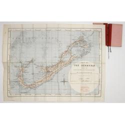
Map of the Bermudas. Compiled from Ordnance Survey Map of 1902, & Admiralty Chart. (1900) Geographical Section. General. Staff. No.3951. Fridded and Railways added 1933. . .
A scarce map of the Bermuda's, compiled from Ordnance Survey Map of 1902, with red grid system and railways added 1933. Scale two inches to one Statute Mile.
Place & Date: London, War Office. 1933
Selling price: $800
Sold in 2017
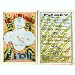
Antilla Holandesas. Curazao.
Unique manuscript map of Curaçao, Bonaire, and Aruba. Award-winning manuscript card, prepared by Antonio Raggio for the 11th Congreso de la Union Postal Universal (World...
Place & Date: Buenos Aires, 1939
Selling price: $375
Sold in 2018
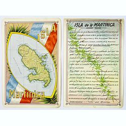
Isla Martinica.
A beautiful hand colored, hand drawn map of the French Caribbean island of Martinique, prepared for the Buenos Aires 1939 Philatelic Exhibition, with separate text with d...
Place & Date: Buenos Aires, 1939
Selling price: $21
Sold in 2019
![Horta and Pim Bays / Fayal Channel [Azores].](/uploads/cache/43825-250x250.jpg)
Horta and Pim Bays / Fayal Channel [Azores].
Two charts on one sheet of Horta and Pim Bays and the Fayal Channel in the Azores in the Atlantic Ocean, originally published by the Hydrographic Office in 1849, but this...
Place & Date: London, [1849] 1941
Selling price: $105
Sold in 2019
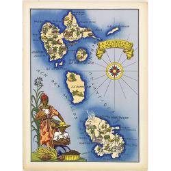
La Guadeloupe La Martinique.
Very decorative, informative map the French islands of Guadeloupe and Martinique among others. The map is filled with buildings, animals, a ship, figures and three locals...
Place & Date: France, 1943
Selling price: $90
Sold in 2010
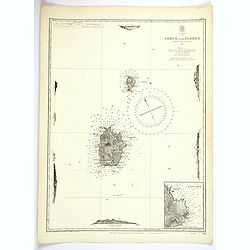
Azores. Corvo and Flores.
A large updated British Sea Chart from an original survey undertaken by Capt. A.T.E. Vidal, R.N. in 1844 of the islands of Corvo and Flores in the Azores Archipelago in t...
Place & Date: London, 1946
Selling price: $45
Sold in 2023
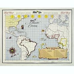
Track Chart
Map of the Atlantic Ocean, used as a hand out to the passangers to keep daily track.
Place & Date: New Orleans, c. 1950
Selling price: $65
Sold in 2015
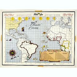
Track Chart.
Map of the Atlantic Ocean, used as a hand out to the passengers to keep daily track.Read more Pictorial Maps [+]
Place & Date: New Orleans, c. 1950
Selling price: $2
Sold in 2017
Jamaica.
This is the map of Jamaica is from a plano edition of the very scarce German edition of Carey & Lea's "A Complete Historical, Chronological, and Geographical Ame...
Place & Date: Weimar, 1822-25
Selling price: $190
Sold
Cuba und die Bahama Inseln.
This is the map of Cuba, includes the Bahama's and southern tip of Florida is from a plano edition of the very scarce German edition of Carey & Lea's "A Complete...
Place & Date: Weimar, 1822-25
Selling price: $190
Sold
Hayti.
This is the map of Haiti is from a plano edition of the very scarce German edition of Carey & Lea's "A Complete Historical, Chronological, and Geographical Ameri...
Place & Date: Weimar, 1822-25
Selling price: $190
Sold
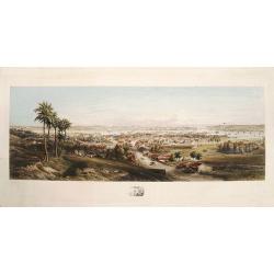
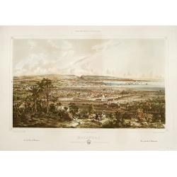
Panorama of Havana.
A fine, large colored steel engraving showing a panoramic view of Havana and its harbour as seen from the south or southeast. The city centre is depicted in remarkable de...
Place & Date: [Havana, G.B. Haase, 1854].
Selling price: $2000
Sold
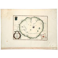
Isola di MARIA GALANTE neel Antilli. . .
A nice example of Coronelli's map of the island of Maria Galante, from his 'Isolario Dell'Atlante Veneto'. This is one of the few separate maps of the island of Marie-Gal...
Place & Date: Venice, ca 1690
Selling price: $100
Sold in 2020
Matanzas: vista g'ral tomada desde el monte del Cafetal de..
Large colored lithograph from the series ,Isla de Cuba Pintoresca., Matanzas: vista g'ral tomada desde el monte del Cafetal de D. Vicente Guerrero. A large lithographed v...
Place & Date: Havana, Sergio Martin, [1856?].
Selling price: $2000
Sold
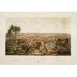
Puerto-Principe: vista g'ral tomada desde El Cristo.
Large colored lithograph from the series ,Isla de Cuba Pintoresca.A splendid, large lithographed view of the city of Puerto-Principe, (now Camag³ey) as seen from the eas...
Place & Date: Havana, Lith. del Gobierno, [1856?].
Selling price: $2000
Sold
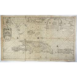
Nieuwe en Naaukeurige Paskaart van Het Eyland Hispaniola of St. Domingo met alle dresslss Havenen, Dieptens en Ankergronden, als meede de door passeeringe tusche de Caiques en andere Eylanden. naer de Opservatien van Monsr. Frezier. . .​
This rare magnificent large chart of Hispaniola and Puerto Rico was published by Johannes van Keulen II. The chart was compiled from the chart made by Amedee Francois Fre...
Place & Date: Amsterdam, ca. 1742
Selling price: $700
Sold in 2018
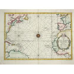
Carte de l' Ocean Occidental.
Jaques Nicolas Bellin (1702-720) was the most important French hydrographer of the 18th century. Sea-atlas 'Hydrographique Français' , 1756-65, atlas to accompany Prévo...
Place & Date: Paris, 1746.
Selling price: $250
Sold
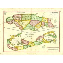
La Jamaique..Golfe du Mexique/ La Bermude.
"Two maps on one sheet; Jamaica and Bermuda. George Louis Le Rouge was active from 1740- till 1780 as a publisher, and was appointed engineer for the King of France....
Place & Date: Paris 1748.
Selling price: $250
Sold
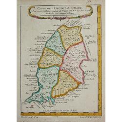
Carte de l' Isle de la Grenade.
Jaques Nicolas Bellin (1702-720) was the most important French hydrographer of the 18th century. Sea-atlas 'Hydrographique Français' , 1756-65, atlas to accompany Prévo...
Place & Date: Paris, c.1755.
Selling price: $70
Sold
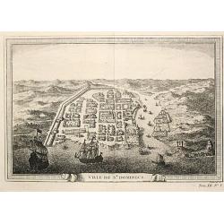
Ville de St. Domingue.
An attractive view of the town of St. Domingue.
Place & Date: Paris, c. 1760.
Selling price: $100
Sold
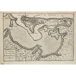
De Hoofdstad en Haven van 't Eiland Porto Rico in de Westindien.
Izaak Tirion (d. 1769) Amsterdam publisher. His 'Nieuwe en beknopte handatlas' saw 6 editions between before 1740 and after 1784. Also 'Tegenwoordige staat van alle volke...
Place & Date: Amsterdam, 1765.
Selling price: $145
Sold
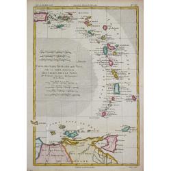
Carte des Isles Antilles ou du Vent avec la Partie orientale des Isles sous le Vent.
Rigobert Bonne (1727-1795), French cartographer. His maps are found in a.o. Atlas Moderne (1762), Raynal's Histoire Philos. du Commerce des Indes (1774) and Atlas Encyclo...
Place & Date: Paris, 1774.
Selling price: $110
Sold
!["Nederlandsch West - Indië. [7 maps on one sheet, including Curaç.]"](/uploads/cache/15951-250x250.jpg)
"Nederlandsch West - Indië. [7 maps on one sheet, including Curaç.]"
"An excellent engraving of the Dutch possessions in the West Indies. Seven maps on one sheet, Surinam, St. Martin, Bonaire, Curaç, Aruba, St.Eustatius and...
Place & Date: The Netherlands c.1900.
Selling price: $100
Sold
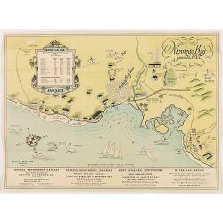
Montego Bay Jamaica, B.W.L.
Beautiful vintage pictorial tourist map of the Montego Bay in Jamaica, with key to distances to hotels and guest houses. In lower part publicity for railway and motor car...
Place & Date: London,
Selling price: $50
Sold in 2020