Search Listings matching "langenes"
![Venuxinus Comitatus. [Vaucluse]](/uploads/cache/43427-250x250.jpg)
Venuxinus Comitatus. [Vaucluse]
A pleasant miniature map of the Vaucluse region of S.E. France, as published by Petrus Bertius in Amsterdam at the beginning of the seventeenth century. Many mountains as...
- $100 / ≈ €94
Place & Date: Amsterdam, 1606
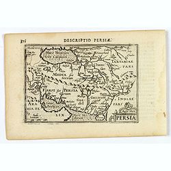
Persia.
A decorative miniature map of Persia, stretching from the Tigris River in the west to the Indus River in the east. As far north as the Caspian Sea. Published by Petrus B...
- $175 / ≈ €164
Place & Date: Amsterdam, 1606
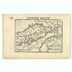
Malacca.
A nice miniature map of Malacca, A Malaysian state on the southern Malay peninsular, next to the Strait of Malacca. North is orientated to the left Published by Petrus B...
- $300 / ≈ €281
Place & Date: Amsterdam, 1606
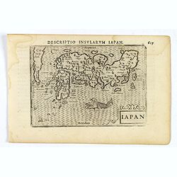
Iapon.
An attractive miniature map of Japan, published by Petrus Bertius, in Amsterdam at the beginning of the seventeenth century.The quirky map is shows the country in a disto...
- $250 / ≈ €234
Place & Date: Amsterdam, 1606
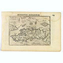
Decriptio Hispaniolae.
A miniature map of Hispaniola, (modern day Haiti and Dominican Republic), as well as the extreme eastern parts of Cuba. With a simple strap-work title and a scale in Germ...
- $150 / ≈ €140
Place & Date: Amsterdam, 1606
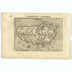
Descriptio Tercerae.
An attractive miniature map of The Azorian island of Terceira, in the Atlantic Ocean. Published by Petrus Bertius, in Amsterdam at the turn of the seventeenth century. Di...
- $100 / ≈ €94
Place & Date: Amsterdam, 1606
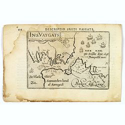
Descriptio Freti Vaigats.
Finely engraved map of the Vaigach Straits, from Bertius's rare miniature atlas. The map focuses on the straits between Novaya Zemlya and the Russian mainland, which had ...
- $150 / ≈ €140
Place & Date: Amsterdam, 1606
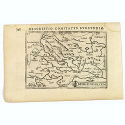
Descriptio Comitatus Burgundiae.
A decorative small map of region around Dijon, Halons and Dole in Burgundy. Features a nice strap-work title, shows rivers and settlements. From the Bertius atlas Tabular...
- $100 / ≈ €94
Place & Date: Amsterdam, 1606
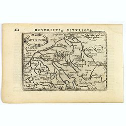
Descriptio Biturigum.
A charming small map of central France. Showing the areas around the rivers Loire, Auron, Allier and Yevre. Nevers and Bourges depicted. From the Bertius atlas Tabularum ...
- $100 / ≈ €94
Place & Date: Amsterdam, 1606
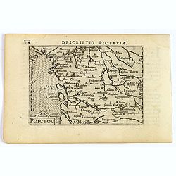
Descriptio Pictaviae.
A charming small map of Poitou in west central France. Showing Cognac, Limoges, Perigord, Poitiers and Angouleme. From the Bertius atlas Tabularum geographicarum contract...
- $100 / ≈ €94
Place & Date: Amsterdam, 1606
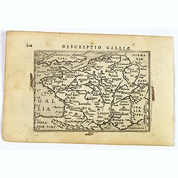
Descriptio Galliae.
A charming small map of ancient Gaul, France under Roman occupation. Featuring most major cities, rivers, mountains and regions are named. From the Bertius atlas Tabularu...
- $100 / ≈ €94
Place & Date: Amsterdam, 1606
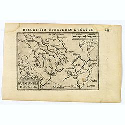
Descriptio Burgundiae Ducatus.
A decorative small map of region around Dijon, Chalons and Dole in Burgundy. Shows many rivers including the Seine, Saone and Brune. It features a nice strap-work title, ...
- $100 / ≈ €94
Place & Date: Amsterdam, 1606
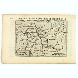
Descriptio Leodiensis Dioecesis.
A decorative map of the ancient Diocese of liege in Belgium, highlighting cities such as Huy, Liege, Tongeren (old capital), Namur and Maastricht. North is orientated to ...
- $100 / ≈ €94
Place & Date: Amsterdam, 1606
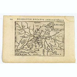
Aniou.
Anjou is a historical province of France, straddling the lower Loire River. Its capital was Angers. It bordered Brittany to the west, Maine to the north, Touraine to the ...
- $100 / ≈ €94
Place & Date: Amsterdam, 1606
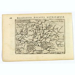
Lotharingia.
Lothringaria (Lorraine) is a historical province of N.E. France, it features the cities of Sarrebourg, Metz, Toul and Nancy. With excellent physical and topographical det...
- $100 / ≈ €94
Place & Date: Amsterdam, 1606
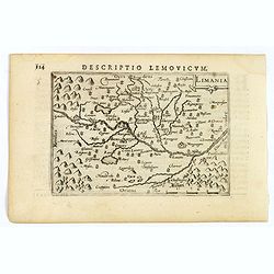
Limania.
A pleasant miniature map of the Limousin region of central France, the area surrounding Clermont Ferrand. Good map detail. From the Bertius atlas Tabularum geographicarum...
- $100 / ≈ €94
Place & Date: Amsterdam, 1606
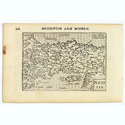
Natolia.
A miniature map of Turkish Natolia, published by Petrus Bertius in Amsterdam, at the beginning of the seventeenth century. This attractive small map features hatching in ...
- $150 / ≈ €140
Place & Date: Amsterdam, 1606
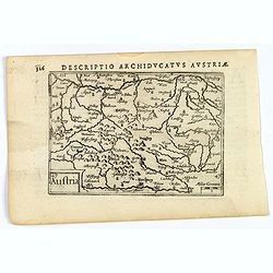
Austria.
A decorative miniature map of the area to the south of Vienna in southern Austria, published by Petrus Bertius in Amsterdam, at the beginning of the seventeenth century. ...
- $100 / ≈ €94
Place & Date: Amsterdam, 1606
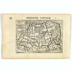
Tartaria.
A fine miniature map showing China, Korea and Russia. Title cartouche on the upper left corner. First published in 1598 in his Caert-Thresoor, the plates were executed by...
- $100 / ≈ €94
Place & Date: Amsterdam, 1606
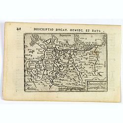
Descriptio Ducat. Ozwiec. et Zato.
An original early 17th century copper engraved miniature antique map of the Oswiecim (Auschwitz) and Zator area of southern Poland by Petrus Bertius. The title is display...
- $100 / ≈ €94
Place & Date: Amsterdam, 1606
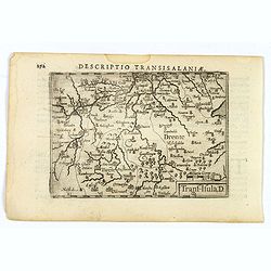
Descriptio Transisalaniae.
An original early 17th century copper engraved miniature antique map of the eastern Dutch region of Overijssel by Petrus Bertius. The title is displayed in a simple strap...
- $100 / ≈ €94
Place & Date: Amsterdam, 1606
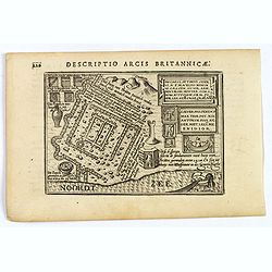
Descriptio Arcis Britannicae.
An original early 17th century copper engraved miniature antique map of the Roman remains in the sand dunes near Katwijk aan Zee in south Holland by Petrus Bertius. In Ro...
- $100 / ≈ €94
Place & Date: Amsterdam, 1606
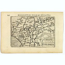
Geldria.
An original early 17th century copper engraved miniature antique map of the Dutch province of Gelderland by Petrus Bertius, that was published in Amsterdam at the beginni...
- $100 / ≈ €94
Place & Date: Amsterdam, 1606
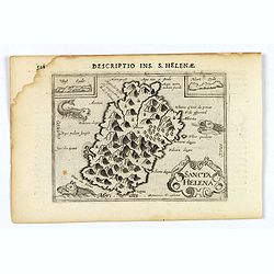
Sancta Helena.
An attractive small map of the south Atlantic island of St. Helena. Two years after the publication of Linschoten's Itinerario, the first map of St. Helena appeared in 15...
- $100 / ≈ €94
Place & Date: Amsterdam, 1606
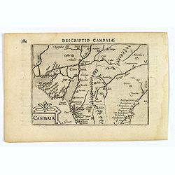
Descriptio Cambaiae.
A very decorative little map of northern India with Gujarat and the Indus river, bordering Pakistan. Naming major towns represented by symbols, major rivers, mountains, a...
- $100 / ≈ €94
Place & Date: Amsterdam, 1606
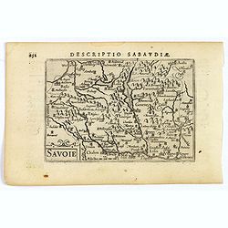
Savoie.
A decorative miniature map of Savoy - a cultural region in Central Europe that comprises roughly the territory of the Western Alps between Lake Geneva in the north and Da...
- $100 / ≈ €94
Place & Date: Amsterdam, 1606
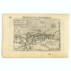
Descriptio Provinciae.
A decorative miniature map of Provence - a geographical region and historical province of south-eastern France, which extends from the left bank of the lower Rhône River...
- $100 / ≈ €94
Place & Date: Amsterdam, 1606
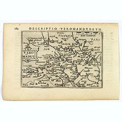
Descriptio Veromanduorum.
A decorative miniature map of Aisne (Vermandois), a French department in the Hauts-de-France region of northern France. It is named after the river Aisne. The map is cent...
- $100 / ≈ €94
Place & Date: Amsterdam, 1606
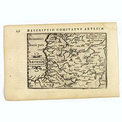
Artesia.
A decorative miniature map of Artois, a historical northern French province that borders Belgium. A map full of detail and is expertly engraved. With the cities of Boulo...
- $100 / ≈ €94
Place & Date: Amsterdam, 1606
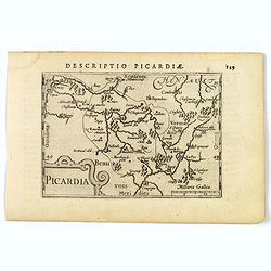
Picardia.
A decorative miniature map of Picardy, a historical northern French region. A map that appears to be sparsely populated is still full of detail with great attention to de...
- $100 / ≈ €94
Place & Date: Amsterdam, 1606
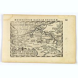
Descriptio Galliae Belgicae.
A decorative miniature map of a section of ancient France, and that of Belgium. Features a nice strap-work title, shows rivers and settlements. From the Bertius atlas Tab...
- $100 / ≈ €94
Place & Date: Amsterdam, 1606
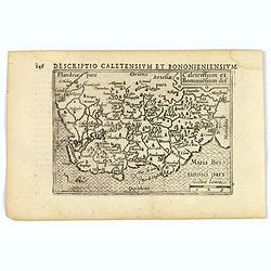
Caletensium et Bononiesium def.
An decorative miniature map of the N.W. France, including Calais and Boulogne. A map full of detail and attractive embelishments. North is orientated to the left. From th...
- $100 / ≈ €94
Place & Date: Amsterdam, 1606
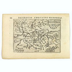
Hannonia.
An attractive miniature map of the Belgian, region of Hainaut, published by Petrus Bertius, in Amsterdam at the beginning of the seventeenth century. It features a small ...
Place & Date: Amsterdam, 1606
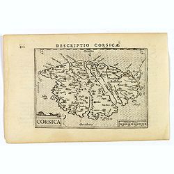
Corsica.
A fine miniature map of the French island of Corsica, published by Petrus Bertius in Amsterdam early in the seventeenth century. The map features a strap-work title carto...
- $300 / ≈ €281
Place & Date: Amsterdam, 1606
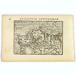
Portugallia.
A nice miniature map of Portugal, published by Petrus Bertius, in Amsterdam, at the beginning of the seventeenth century. North is orientated to the right. Strap-work tit...
Place & Date: Amsterdam, 1606
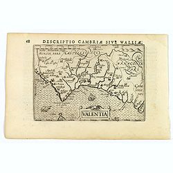
Valentia.
A fine miniature map of the Spanish province of Valencia, published by Petrus Bertius in Amsterdam early in the seventeenth century. The map features a nice strap-work ti...
Place & Date: Amsterdam, 1606
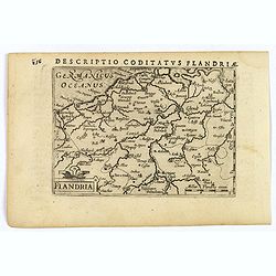
Flandria.
A lovely set of miniature map of Flanders. With an attractive strap-work title, and with detailed topography and information. Bertius (1565-1629) was a Flemish cartograph...
Place & Date: Amsterdam, 1606
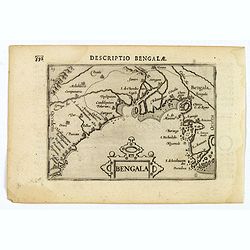
Bengala.
A lovely miniature map of a section of the Bay of Begal, published by Petrus Bertius, in Amsterdam at the beginning of the seventeenth century. There is a decorative stra...
Place & Date: Amsterdam, 1606
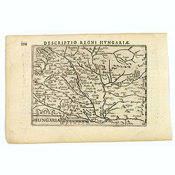
Hungaria.
A lovely miniature map of Hungary, published by Petrus Bertius, in Amsterdam at the beginning of the seventeenth century. There is a decorative strap-work title, and the ...
Place & Date: Amsterdam, 1606
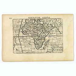
Africa.
A lovely miniature map of the continent of Africa, published by Petrus Bertius, in Amsterdam at the beginning of the seventeenth century. There is a small strap-work titl...
Place & Date: Amsterdam, 1606